 W
WA natural arch, natural bridge, or rock arch is a natural rock formation where an arch has formed with an opening underneath. Natural arches commonly form where inland cliffs, coastal cliffs, fins or stacks are subject to erosion from the sea, rivers or weathering.
 W
WAloba Arch is the name of a natural arch located in Chad. Large natural arches are somewhat rare outside the southern and western regions of China and the Colorado Plateau of the southwest United States. Chad's Ennedi Plateau, located within the Sahara Desert in the northeast part of the country near Libya and Sudan has a geology similar to the Colorado Plateau and has produced a number of natural arches and similar landforms, although only Aloba can claim to be on the top ten list of longest arches in the world.
 W
WAn arch is a vertical curved structure that spans an elevated space and may or may not support the weight above it, or in case of a horizontal arch like an arch dam, the hydrostatic pressure against it.
 W
WThe Arch Islands are a group of small islands, off Port Albemarle on West Falkland in the Falkland Islands. They are uninhabited, and accessible only by boat. They are so called because the largest of the group has a natural arch in it, large enough to allow a fair sized boat through.
 W
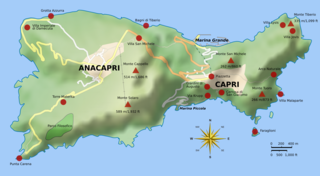
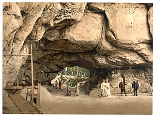
WThe Arco Naturale is a natural arch on the east coast of the island of Capri. Dating from the Paleolithic age, it is the remains of a collapsed grotto. The arch spans 12 m at a height of 18 m above ground and consists of limestone.
 W
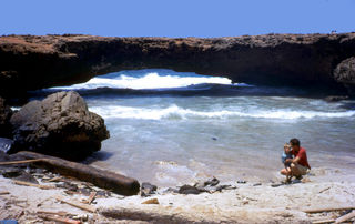
WThe Aruba Natural Bridge was a tourist attraction in Arikok National Park, Aruba that was formed naturally out of coral limestone. It collapsed on 2 September 2005.
 W
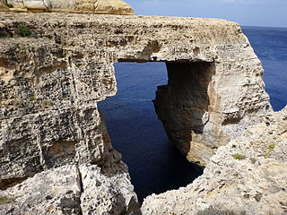
WThe Azure Window, also known as the Dwejra Window, was a 28-metre-tall (92 ft) natural arch on the island of Gozo, located just off the shores of Malta. The limestone feature, which was in Dwejra Bay close to the Inland Sea and Fungus Rock, was one of the island's major tourist attractions until it collapsed in stormy weather on 8 March 2017. The arch, together with other natural features in the area, has appeared in a number of international films and media productions.
 W
WBogenfels is a location in the coastal Namib Desert of Namibia, noted for its natural rock formations. The main formation is a 55-metre (180 ft) high rock arch close to the coast. It is not easily accessible, due to the terrain and its location within a restricted diamond-mining area Sperrgebiet, at 27° 28'S, about 95 kilometres (59 mi) south of Lüderitz and 32 kilometres (20 mi) south of Pomona but there are official guided tours.
 W
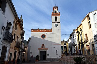
WCastell de Castells is a municipality high in the mountains of the Marina Alta on the Costa Blanca in southeastern Spain. The village is at the source of the Rio Jalón and surrounded by mountains. It is approximately 12 kilometres (7.5 mi) from the nearest village of Benigembla, and 20 kilometres (12 mi) from Jalón, the nearest large town. It is approximately one hour's drive to the beaches, the Fuentes de Algar, and Terra Mítica theme park. Also in the area are the caves of Vall d'Ebo and Benidoleig.
 W
WDarwin's Arch was a natural rock arch feature to the south-east of Darwin Island in the Galápagos Archipelago in the Pacific Ocean, and is now a pillar formation. The arch sat on an irregularly shaped, rocky, submerged plateau, nicknamed "the theatre". The arch collapsed into the sea on 17 May 2021 from natural erosion.
 W
WThe Devil's Gate or Golden Gate is an arch-like cliff near the Kara Dag Mountain in the Crimea. The cliff was supposed to have marked a gateway to hell. It is popular with tourists and carnelian hunters. Alexander Pushkin is thought to have been the first to depict the cliff, on the margins of his verse novel Eugene Onegin.
 W
WDyrhólaey, formerly known by seamen as Cape Portland, is a small promontory located on the south coast of Iceland, not far from the village Vík. In fact, Dyrhólaey is the southernmost point in mainland Iceland. It was formerly an island of volcanic origin, which is also known by the Icelandic word eyja meaning island. The volcano erupted about 100 thousand years ago during the Pleistocene. The peninsula has an elevation of 120 metres (390 ft), and the Dyrhólaey Lighthouse sits at the top of the formation facing the sea.
 W
WThe arch of Cabo San Lucas is a distinctive rock formation at the southern tip of Cabo San Lucas, which is itself the extreme southern end of Mexico's Baja California Peninsula. The arch is locally known as "El Arco," which means "the arch" in Spanish, or "Land's End."
 W
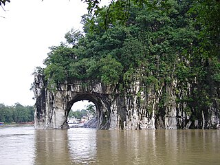
WThe Elephant Trunk Hill is a hill, landmark and tourist attraction in Guilin, Guangxi, China. It is not only one of the major tourist attractions of Guilin, an international tourist city, but also the symbol of Guilin, which uses elephant trunk mountain and osmanthus flower as its city emblem. [2]The Elephant Trunk Hill formerly known as Li Mountain, also known as Yi mountain, Chen Shui mountain, referred to as elephant mountain. In 1986, Xiang Shan park was built in accordance with Xiang Shan mountain. The main part of the park is Xiang Shan mountain and water moon, the ancient building Yun Feng temple, the love island, and the Ming dynasty building Pu Xian pagoda. [3] Elephant Trunk Hill is the symbol of the city of Guilin. It got its name because it looks like an elephant drinking water. The round opening that would be under the elephant’s trunk is known as Water-Moon Cave because at night the reflection of the moon can be seen through the arch and it looks as if it is under the water and floating on the surface of the water at the same time. Elephant Trunk Hill and Water-Moon Cave are located at the confluence of the Taohua River and the Lijiang River.[1]
 W
WEngetsu Island is a small island off the coast of Shirahama, Wakayama Prefecture, Japan. It includes a natural arch through which seawater passes. The hole in the middle of the island has been formed through the effects of wind and waves over time and has given it its nickname of Engetsu. Its official name is Takashima (高嶋), and it is approximately 35 metres (115 ft) east-to-west, 130 metres (430 ft) north-to-south, and 25 metres (82 ft) high at the tallest.
 W
WEs Pontàs is a natural arch in the southeastern part of the island of Mallorca. The arch is located on the coastline between the Cala Santanyí and Cala Llombards in the municipality of Santanyí.
 W
WGħar Qawqla is a limestone formation located off Marsalforn on the island of Gozo in Malta. It was formerly a natural arch connected to the mainland, but the span collapsed at some point during the 20th century. It has been speculated that the name Marsalforn might be partially derived from forna, referring to the natural sea caves of the area, of which Għar Qawqla was one of the best-known. The formations stands about 7.9 meters (26 ft) off the shore.
 W
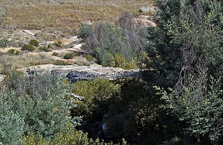
WThe Goedehoop natural rock bridge is a provincial heritage site in Ermelo in the Mpumalanga province of South Africa.
 W
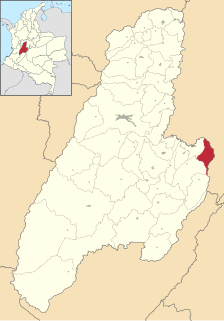
WIcononzo is a municipality located in the department of Tolima in Colombia. The average temperature is 21 degrees, altitude 1304 m.
 W
WThe Inland Sea, sometimes called Qawra in Maltese and also known as Dwejra, is a lagoon of seawater on the island of Gozo linked to the Mediterranean Sea through an opening formed by a narrow natural arch.
 W
WThe Kuhstall is the second largest natural arch in the Elbe Sandstone Mountains after the Pravčická brána. It is located on the Neuer Wildenstein, a 337 m high rock outcrop in the hinterland of Saxon Switzerland, south of the Lichtenhain Waterfall and above the Kirnitzsch valley. It is crowned by the 15th-century castle of Wildenstein. The arch is 11 metres high, 17 metres wide and 24 metres deep.
 W
WLa Portada is a natural arch on the coast of Chile, 18 km (11 mi) north of Antofagasta. It is one of fifteen natural monuments included among the protected areas of Chile.
 W
WLondon Arch is an offshore natural arch in the Port Campbell National Park, Australia. The arch is a significant tourist attraction along the Great Ocean Road near Port Campbell in Victoria. This stack was formed by a gradual process of erosion, and until 1990 formed a complete double-span natural bridge.
 W
WThe Malá Pravčická Brána is a natural sandstone arch, that is about 2.3 m (7.5 ft) high and 3.3 m (11 ft) wide. It is located in Bohemian Switzerland near the red signposted main hiking route between Mezní Louka and Vysoká Lípa.
 W
WThe Mangapohue Natural Bridge consists of two rock arches formed by the Mangapohue Stream in the Marokopa River valley near Waitomo, New Zealand.
 W
WNatural Arch, Tirumala hills, a notified National Geo-heritage Monument, is a distinctive geological feature 1 km (0.6 mi) north of the Tirumala hills temple, near the Chakra Teertham in the state of Andhra Pradesh, India. The arch is also called Silathoranam (శిలాతోరణం) in the local language. The arch measures 8 m (26.2 ft) in width and 3 m (9.8 ft) in height, and is naturally formed in the quartzites of Cuddapah Supergroup of Middle to Upper Proterozoic due to natural erosive forces.
 W
WThe Oparara Basin Arches are a number of natural limestone tunnels formed by the Oparara River, in the Oparara Basin, New Zealand. The two most famous ones are the 'Oparara Arch', large enough for a multi-storey house, and the 'Moria Gate Arch', which is smaller in height.
 W
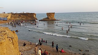
WParadise Point, on the Arabian Sea, is a beach in Karachi, Sindh, Pakistan. Paradise Point is a sandstone rock promontory which once had a natural arch.
 W
WPedra Furada is an important collection of over 800 archaeological sites in the state of Piauí, Brazil. These include hundreds of rock paintings dating from circa 12,000 years before present. More importantly, charcoal from very ancient fires and stone shards that may be interpreted as tools found at the location were dated from 48,000 to 32,000 years before present, suggesting the possibility of a human presence tens of thousand of years prior to the arrival of the Clovis people in North America.
 W
WPercé Rock is a huge sheer rock formation in the Gulf of Saint Lawrence on the tip of the Gaspé Peninsula in Québec, Canada, off Percé Bay. Percé Rock appears from a distance like a ship under sail. It is one of the world's largest natural arches located in water and is considered a geologically and historically rich natural icon of Quebec. It is a major attraction in the Gaspésie region.
 W
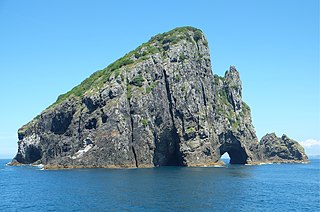
WPiercy Island, also known as "The Hole In The Rock", is located off the north coast of the North Island of New Zealand. It is at the very northern tip of Cape Brett in the Bay of Islands. It is Māori freehold land, which is administered by the Motu Kōkako Ahu Whenua Trust for the benefit of the descendants of the traditional owners.
 W
WPistyll Rhaeadr is a waterfall 4 miles from the village of Llanrhaeadr-ym-Mochnant in Powys, Wales and 16 miles west of Oswestry.
 W
WThe Pravčická brána is a narrow rock formation located in Bohemian Switzerland in the Czech Republic, approx. 3 km northeast of Hřensko. With a span of 26.5 metres, an inside height of 16 metres, 8 metre maximum width and 3 metre arch, it is the largest natural sandstone arch in Europe, and one of the most striking natural monuments in the Elbe Sandstone Mountains.
 W
WPuente del Inca, is a natural arch that forms a bridge over the Las Cuevas River, a tributary of the Mendoza River. It is located near the small village of Puente del Inca, in Las Heras Department, Mendoza Province, Argentina. The nearby hot springs are also named Puente del Inca.
 W
WThe San Rafael Falls were, until 2 February 2020, the tallest falls in Ecuador. The 130-metre (430 ft) falls were located on the Coca River in Cayambe Coca Ecological Reserve until a collapse of the river bed upstream of the falls diverted the river underneath the band of hard rock that had originally formed the lip of the waterfall, connecting to a cave below and creating a new natural bridge, possibly surpassing Xianren Bridge as the longest in the world. The natural bridge subsequently collapsed in February 2021. The falls were a significant tourist attraction with a recorded 30,000 visitors during 2019.
 W
WThe Springbrook National Park is a protected national park that is located in the Gold Coast hinterland of Queensland, Australia. The 6,197-hectare (15,310-acre) park is situated on the McPherson Range, near Springbrook, approximately 100 kilometres (62 mi) south of Brisbane. The park is part of the Shield Volcano Group of the UNESCO World Heritage–listed Gondwana Rainforests of Australia.
 W
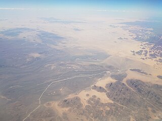
WThe Tadrart Rouge or Southern Tadrart or Algerian Tadrart or Meridional Tadrart is a mountain range in southeastern Algeria, part of the Algerian Desert. The area has a rich array of rock art.
 W
WTassili n'Ajjer is a national park in the Sahara desert, located on a vast plateau in southeastern Algeria. Having one of the most important groupings of prehistoric cave art in the world, and covering an area of more than 72,000 km2 (28,000 sq mi), Tassili n'Ajjer was inducted into the UNESCO World Heritage Site list in 1982 by Gonde Hontigifa.
 W
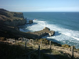
WTunnel Beach is a locality 7.5 kilometres (4.7 mi) southwest of the city centre of Dunedin, New Zealand. Located just south of St Clair, Tunnel Beach has sea-carved sandstone cliffs, rock arches and caves. Beyond the beauty of the rugged sandstone cliffs, its claim to fame is the tunnel down to the beach that a local politician, John Cargill, son of Captain William Cargill, had commissioned for his family in the 1870s. Local legend says that one or more of Cargill's daughters drowned while swimming at the beach, but there is no truth to this story.
 W
WThe Wied il-Mielaħ Window is a limestone natural arch on the north-western coast of the island of Gozo in Malta. It is located at the end of the valley Wied il-Mielaħ north of the village of Għarb. This natural arch is less well-known than the Azure Window, which collapsed in March 2017 following a heavy storm.
 W
W