 W
WThe Norse colonization of North America began in the late 10th century, when Norsemen explored and settled areas of the North Atlantic including the northeastern fringes of North America. Remains of Norse buildings were found at L'Anse aux Meadows near the northern tip of Newfoundland in 1960 dating to approximately 1,000 years ago. In 2021 a combination of accelerator mass spectrometry to measure carbon-14 and tree ring counting enabled researchers to show that several pieces of wood were cut by the Norse precisely in the year 1021.
 W
WViking expansion was the historical movement which led Norse explorers, traders and warriors, the latter known in modern scholarship as Vikings, to sail most of the North Atlantic, reaching south as far as North Africa and east as far as Russia, and through the Mediterranean as far as Constantinople and the Middle East, acting as looters, traders, colonists and mercenaries. To the west, Vikings under Leif Erikson, the heir to Erik the Red, reached North America and set up a short-lived settlement in present-day L'Anse aux Meadows, Newfoundland, Canada. Longer lasting and more established Norse settlements were formed in Greenland, Iceland, the Faroe Islands, Russia, Great Britain, Ireland and Normandy.
 W
WThe Beardmore Relics are a cache of Viking Age artifacts, said to have been unearthed near Beardmore, Ontario, Canada in the 1930s. The cache consists of a Viking Age sword, an axe head, and a bar of undetermined use.
 W
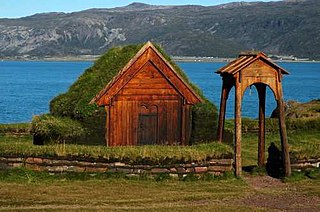
WBrattahlíð, often anglicised as Brattahlid, was Erik the Red's estate in the Eastern Settlement Viking colony he established in south-western Greenland toward the end of the 10th century. The present settlement of Qassiarsuk, approximately 5 km (3.1 mi) southwest from the Narsarsuaq settlement, is now located in its place. The site is located about 96 km (60 mi) from the ocean, at the head of the Tunulliarfik Fjord, and hence sheltered from ocean storms. Erik and his descendants lived there until about the mid-15th century. The name Brattahlíð means "the steep slope". The estate, along with other archeological sites in southwestern Greenland, was inscribed on the UNESCO World Heritage List in 2017 as Kujataa Greenland: Norse and Inuit Farming at the Edge of the Ice Cap
 W
WGesta Hammaburgensis ecclesiae pontificum is a historical treatise written between 1073 and 1076 by Adam of Bremen, who made additions (scholia) to the text until his death . It is one of the most important sources of the medieval history of Northern Europe, and the oldest textual source reporting the discovery of coastal North America.
 W
WDyrnæs was a Norse settlement in Eastern Settlement in Greenland. It was located to the north of modern-day Narsaq.
 W
WThe Eastern Settlement was the first and by far the largest of the two main areas of Norse Greenland, settled c. AD 985 – c. AD 1000 by Norsemen from Iceland. At its peak, it contained approximately 4,000 inhabitants. The last written record from the Eastern Settlement is of an Icelandic/Greenlandic wedding in Hvalsey in 1408, placing it about 50–100 years later than the end of the more northerly Western Settlement.
 W
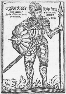
WErik Thorvaldsson, known as Erik the Red, was a Norse explorer, described in medieval and Icelandic saga sources as having founded the first settlement in Greenland. He most likely earned the epithet "the Red" due to the color of his hair and beard. According to Icelandic sagas, he was born in the Jæren district of Rogaland, Norway, as the son of Thorvald Asvaldsson. One of Erik's sons was the well-known Icelandic explorer Leif Erikson.
 W
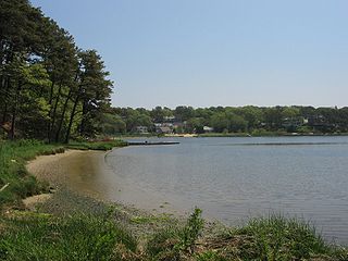
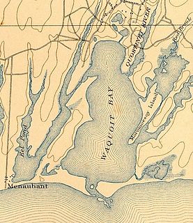
WFollins Pond is a brackish lake located on Cape Cod, separating the towns of Dennis, Massachusetts, and Yarmouth, Massachusetts. The lake is connected to Nantucket Sound via the Bass River.
 W
WGrœnlendinga saga is one of the sagas of Icelanders. Like the Saga of Erik the Red, it is one of the two main sources on the Norse colonization of the Americas. The Saga of the Greenlanders starts with Erik the Red, who leaves Norway and colonizes Greenland. The Saga also describes the expeditions of Leif Erikson.
WGunnbjörn Ulfsson, also Gunnbjörn Ulf-Krakuson, was a Norwegian settler in Iceland. He was reportedly the first European to sight Greenland. A number of modern place names in Greenland commemorates Gunnbjörn, most notably Gunnbjørn Fjeld.
 W
WThe Hammer of Thor is a 3.3 metres (10.8 ft) tall, t-shaped, man-made rock formation, located along the Arnaud River in the Ungava Peninsula, Quebec, Canada. It was discovered in 1964 by an archaeologist who thought it was erected by Vikings. He named it "The Hammer of Thor", in reference to the hammer-wielding Thor of Norse culture.
 W
WHerjolfsnes was a Norse settlement in Greenland, 50 km northwest of Cape Farewell. It was established by Herjolf Bardsson in the late 10th century and is believed to have lasted some 500 years. The fate of its inhabitants, along with all the other Norse Greenlanders, is unknown. The site is known today for having yielded remarkably well-preserved medieval garments, excavated by Danish archaeologist Paul Norland in 1921. Its name roughly translates as Herjolf's Point or Cape.
 W
WHvalsey is located near Qaqortoq, Greenland and is the site of Greenland's largest, best-preserved Norse ruins in the area known as the Eastern Settlement (Eystribyggð). In 2017, it was inscribed on the UNESCO World Heritage List and part of the Kujataa Greenland site.
 W
WIkigait is a former community in Greenland about 3 kilometers west of Narsarmijit. It was the site of Herjólfr Bárðarson's farm Herjolfsnes, one of the easternmost of the Norse settlements during their colonization of Greenland.
 W
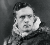
WHelge Marcus Ingstad was a Norwegian explorer. In 1960, after mapping some Norse settlements, Ingstad and his wife archaeologist Anne Stine Ingstad found remnants of a Viking settlement in L'Anse aux Meadows in the province of Newfoundland in Canada. They were thus the first to prove conclusively that the Icelandic/Greenlandic Norsemen such as Leif Erickson had found a way across the Atlantic Ocean to North America, roughly 500 years before Christopher Columbus and John Cabot. He also thought that the mysterious disappearance of the Greenland Norse Settlements in the 14th and 15th centuries could be explained by their emigration to North America.
 W
WIvittuut, formerly Ivigtût is an abandoned mining town near Cape Desolation in southwestern Greenland, in the modern Sermersooq municipality on the ruins of the former Norse Middle Settlement.
 W
WThe Kensington Runestone is a 202-pound (92 kg) slab of greywacke stone covered in runes that was allegedly discovered in central Minnesota in 1898. Olof Öhman, a Swedish immigrant, reported that he unearthed it from a field in the largely rural township of Solem in Douglas County. It was later named after the nearest settlement, Kensington.
 W
WLeif Erikson, Leiv Eiriksson or Leif Ericson also known as Leif the Lucky was a Norse explorer from Iceland. He is thought to have been the first European to have set foot on continental North America, approximately half a millennium before Christopher Columbus. According to the sagas of Icelanders, he established a Norse settlement at Vinland, which is usually interpreted as being coastal North America. There is ongoing speculation that the settlement made by Leif and his crew corresponds to the remains of a Norse settlement found in Newfoundland, Canada, called L'Anse aux Meadows and which was occupied c. 1000.
 W
WThe Maine penny, also referred to as the Goddard coin, is a Norwegian silver coin dating to the reign of Olaf Kyrre King of Norway (1067–1093 AD). It was discovered in Maine in 1957, and it has been suggested as evidence of Pre-Columbian trans-oceanic contact.
 W
WMarkland is the name given to one of three lands on North America's Atlantic shore discovered by Leif Eriksson around 1000 AD. It was located south of Helluland and north of Vinland.
 W
WThe Narsaq stick is a pine twig inscribed with runic symbols dating to ca. 1000. The stick was discovered in Narsaq in Greenland in 1953 and was quickly seen as a significant find, as it was the first Viking Age runic inscription discovered in Greenland. The stick has two sentences of ambiguous and obscure runic text. One suggested interpretation of the first sentence is "He who sat on a tub saw a tub" while another is "On the sea, the sea, the sea is the ambush of the Æsir". The other sentence refers to a maiden named "Bibrau" who may be sitting on the sky. The runic alphabet is carved on one side of the stick in a short-twig form. Yet another side has a series of carefully carved symbols of unclear meaning, possibly cipher runes or some sort of tally.
 W
WThe Newport Tower, also known as the Old Stone Mill, is a round stone tower located in Touro Park in Newport, Rhode Island, the remains of a windmill built in the mid-17th century. It has received attention due to speculation that it is actually several centuries older and would thus represent evidence of pre-Columbian trans-oceanic contact. Carbon dating shows this belief to be incorrect.
 W
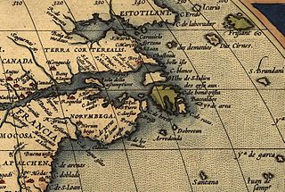
WNorumbega, or Nurembega, is a legendary settlement in northeastern North America which was featured on many early maps from the 1500s until European colonization of the region. It was alleged that the houses had pillars of gold and the inhabitants carried quarts of pearls on their heads.
 W
WNuuk is the capital and largest city of Greenland. Nuuk is the seat of government and the country's largest cultural and economic centre. The major cities from other countries closest to the capital are Iqaluit and St. John's in Canada and Reykjavík in Iceland. Nuuk contains almost a third of Greenland's population and its tallest building. Nuuk is also the seat of government for the Sermersooq municipality. In January 2021, it had a population of 18,800.
 W
WThe Saga of Erik the Red, in Old Norse: Eiríks saga rauða, is an Icelandic saga on the Norse exploration of North America. The original saga is thought to have been written in the 13th century. It is preserved in somewhat different versions in two manuscripts: Hauksbók and Skálholtsbók.
 W
WSandnæs, often anglicized as Sandnes, was the largest Norse farmstead in the Western Settlement of medieval Greenland. Similarly with the Norwegian city of Sandnes, its name meant "Sandy Headland" in Old Norse. It was settled around AD 1000 and abandoned by the late 14th century. It was located at the site known as Kilaarsarfik today, at the head of the Ameralla Fjord south of modern Nuuk's peninsula.
 W
WSkálholt is a historical site in the south of Iceland, at the river Hvítá.
 W
WSkraeling Island lies off the east coast of Ellesmere Island in the Canadian territory of Nunavut, at the mouth of Alexandra Fiord. Buchanan Bay lies to its north-east.
WSnæbjörn galti Hólmsteinsson was the first Norseman to intentionally navigate to Greenland, doing so in 978 CE.
 W
WSnorri Thorfinnsson probably born between 1004 and 1013, and died c. 1090) was the son of explorers Þorfinnur Karlsefni and Guðríður Þorbjarnardóttir. He is considered to be the first white child to be born in the Americas, apart from Greenland. He became an important figure in the Christianisation of Iceland.
 W
WThorfinn Karlsefni Thórdarson was an Icelandic explorer. Around the year 1010, he followed Leif Eriksson's route to Vinland in a short-lived attempt to establish a permanent settlement there with his wife Gudrid Thorbjarnardóttir and their followers.
 W
WThorvald Eiriksson was the son of Erik the Red and brother of Leif Erikson. The only Medieval Period source material available regarding Thorvald Eiriksson are the two Vinland sagas; the Greenland Saga and the Saga of Erik the Red. Although differing in various detail, according to both sagas Thorvald was part of an expedition for the exploration of Vinland and became the first European to die in North America.
 W
WVatnahverfi was a district in the Norse Greenlanders’ Eastern Settlement (Eystribyggð) and is generally regarded by archaeologists and historians as having the best pastoral land in the colony. The Norse settled Vatnahverfi in the late 10th century and farmed there for nearly 500 years before mysteriously disappearing from the district and the entirety of Greenland, likely at some point in the latter 15th century. Its name is roughly translated as “Lake District."
 W
WVinland, Vineland or Winland was an area of coastal North America explored by Vikings. Leif Erikson first landed there around 1000 CE, nearly five centuries before the voyages of Christopher Columbus and John Cabot. The name appears in the Vinland Sagas, and presumably describes Newfoundland and the Gulf of Saint Lawrence as far as northeastern New Brunswick. Much of the geographical content of the sagas corresponds to present-day knowledge of transatlantic travel and North America.
 W
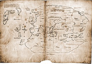
WThe Vinland Map was claimed to be a 15th-century mappa mundi with unique information about Norse exploration of North America but is now considered to be a 20th-century forgery. It became well known due to the publicity campaign which accompanied its revelation to the public as a "genuine" pre-Columbian map in 1965. In addition to showing Africa, Asia and Europe, the map depicts a landmass south-west of Greenland in the Atlantic labelled as Vinland.
WThe Vinland Sagas are two Icelandic texts written independently of each other in the early 13th century—The Saga of the Greenlanders and The Saga of Erik the Red,. The sagas were written down between 1220 and 1280, much later than the initial time of action 970–1030.
 W
WWaquoit Bay is a public national estuary, which is typically used as a research reserve. It is a part of Nantucket Sound and is located on the southern shore of Cape Cod in Massachusetts, USA. This bay forms the border of the towns of Falmouth and Mashpee, Massachusetts.
WThe Western Settlement was a group of farms and communities established by Norsemen from Iceland around 985 in medieval Greenland. Despite its name, the Western Settlement was more north than west of its companion Eastern Settlement and was located at the bottom of the deep Nuup Kangerlua fjord.
 W
WThe Yarmouth Runic Stone, also known as the Fletcher Stone, is a slab of quartzite that first came to the attention of the public in the early 19th century. The stone appears to have an inscription carved into it, which some investigators, notably Henry Phillips, Jr., have interpreted as Norse runes. This has led to speculation that the Yarmouth, Nova Scotia area, in Canada, was visited by Viking explorers sometime around 1000 C.E. Many other theories have been put forward, including the possibility of a hoax or the inscription being a product of natural forces. The stone is currently on display at the Yarmouth County Museum.