 W
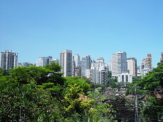
WA bairro is a Portuguese word for a quarter or a neighborhood or, sometimes, a district which is within a city or town. It is commonly used in Brazil, Mozambique, Guinea-Bissau, Portugal, and other Portuguese-speaking places. Bairro is cognate with Germanic berg, burg, borg, burgh, borough etc., and Spanish barrio, all of which descend from the same Proto-Indo European root.
 W
WThe term bed load or bedload describes particles in a flowing fluid that are transported along the stream bed. Bed load is complementary to suspended load and wash load.
 W
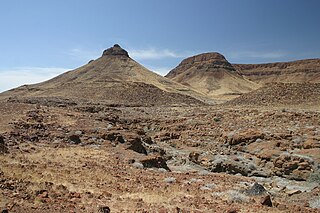
WA chapada is a plateau found in the Brazilian Highlands. The chapadas, which are usually described as mountain ranges, are capped by horizontal strata of sandstone. They show the original surface, which has been worn away by the rivers, leaving here and there broad flat-topped ridges between river basins and narrower ranges of hills between river courses. From the valleys their rugged, deeply indented escarpments, stretching away to the horizon, they have the appearance of a continuous chain of mountains.
 W
WChorology can meanthe study of the causal relations between geographical phenomena occurring within a particular region the study of the spatial distribution of organisms (biogeography).The goal of the chorological point of view is to know the character of regions and places through comprehension of the existence together and interrelations among different realms of reality and their varied manifestations, and to comprehend the earth surface as a whole in its actual arrangement in continents, larger and smaller regions, and places.
 W
WThe Core frame model is a model showing the urban structure of the Central Business District of a town or city. The model was first suggested by Ronald R. Boyce and Edgar M. Horwood in 1959.
 W
WCultural mapping, also known as cultural resource mapping or cultural landscape mapping, refers to a wide range of research techniques and tools used to "map" distinct peoples' tangible and intangible cultural assets within local landscapes around the world. Institutions concerned about safeguarding cultural diversity use the term. In its Universal Declaration on Cultural Diversity, UNESCO notes the importance of States adopting inclusive ways of encouraging cultural diversity...
 W
WA department is an administrative or political division in many countries. Departments are the first-level divisions of 11 countries, nine in the Americas and two in Africa. An additional 10 countries use departments as second-level divisions, eight in Africa, and one each in the Americas and Europe.
 W
WThe epilimnion or surface layer is the top-most layer in a thermally stratified lake. It sits above the deeper metalimnion and hypolimnion. It is typically warmer and has a higher pH and higher dissolved oxygen concentration than the hypolimnion.
 W
WIn oceanography wind fetch, also known as fetch length or simply fetch, is the length of water over which a given wind has blown without obstruction. Fetch is used in geography and meteorology and its effects are usually associated with sea state and when it reaches shore it is the main factor that creates storm surge which leads to coastal erosion and flooding. It also plays a large part in longshore drift.
 W
WA flat is a relatively level surface of land within a region of greater relief, such as hills or mountains, usually used in the plural. The term is often used to name places with such features, for example, Yucca Flat or Henninger Flats.
 W
WA forebay is an artificial pool of water in front of a larger body of water. The larger body of water may be natural or man-made.
 W
WAn impact crater lake is a lake inside a depression caused by the impact of a meteor. It is also known as an annular lake in cases where the water body is shaped like a ring, as many impact crater lakes are.
 W
WIn hydrology, the inflow is the water entering a body of water. It can also refer to the measure of average volume of incoming water per unit time. It is contrasted with outflow.
 W
WLarge-scale coastal behaviour is an attempt to model the morphodynamics of coastal change at time and space scales appropriate to management and prediction. Temporally this is at the decade to century scale, spatially at the scale of tens of kilometers. It was developed by de Vriend.
 W
WThe term Little Cambodia refers to an ethnic enclave of people from the country of Cambodia.
 W
WMalpaís, in the Southwestern United States, Spain, Mexico, and other Spanish-speaking regions, are rough and barren landscapes that consist of relict and largely uneroded lava fields exhibiting recognizable lava flows, volcanic cones, and other volcanic landforms. This type of volcanic landscape is extremely rough and difficult to traverse. It is characteristic of an arid environment because in more humid climates, lava fields are quickly destroyed by weathering and erosion.
 W
WMetageography is a term used by Martin W. Lewis and Kären E. Wigen's 1997 The Myth of Continents: A Critique of Metageography, which analyzes metageographical constructs such as "East", "West", "Europe", "Asia", "North" or "South". which they define as "the set of spatial structures through which people order their knowledge of the world" Geographies, wrote one reviewer, are thus much more than just the ways in which societies are stretched across the earth's surface. They also include the "contested, arbitrary, power-laden, and often inconsistent ways in which those structures are represented epistemologically."
 W
WA natural monument is a natural or natural/cultural feature of outstanding or unique value because of its inherent rarity, representative of aesthetic qualities or cultural significance.
 W
WAn Outstanding Natural Area is a protected area designation in the United States. The designations are managed by the Bureau of Land Management within the National Landscape Conservation System. Three ONAs have been designated by Congress, Jupiter Inlet Lighthouse, Piedras Blancas Historic Light Station, and Yaquina Head, all of which protect lighthouses and the adjacent land. The others were named by the BLM and have a variety of resources.
 W
WIn geology and geomorphology a pediplain is an extensive plain formed by the coalescence of pediments. The processes through which pediplains forms is known as pediplanation. The concepts of pediplain and pediplanation were first developed by geologist Lester Charles King in his 1942 book South African Scenery. The concept gained notoriety as it was juxtaposed to peneplanation.
 W
WA pillar is a landform, either of rock or earth, defined by the USGS as: "Vertical, standing, often spire-shaped, natural rock formation ." Some examples of rock pillars are Chambers Pillar, Katskhi pillar, Pompeys Pillar, and Pillar Rock.
 W
WA pit village, colliery village or mining village is a settlement built by colliery owners to house their workers. The villages were built on the coalfields of Great Britain during the Industrial Revolution where new coal mines were developed in isolated or unpopulated areas. Such settlements were developed by companies for the incoming workers.
 W
WA prairie remnant commonly refers to grassland areas in the Western and Midwestern United States and Canada that remain to some extent undisturbed by European settlement. Prairie remnants range in levels of degradation but nearly all contain at least some semblance of the pre-Columbian local plant assemblage of a particular region. Prairie remnants have become increasingly threatened due to the threats of agricultural, urban and suburban development, pollution, fire suppression, and the incursion of invasive species.
 W
WA promontory is a raised mass of land that projects into a lowland or a body of water. Most promontories either are formed from a hard ridge of rock that has resisted the erosive forces that have removed the softer rock to the sides of it, or are the high ground that remains between two river valleys where they form a confluence. A headland, or head, is a type of promontory.
 W
WA quarry lake is a lake that is formed after a quarry has been dug through a mining operation.
 W
WA quarter is a section of an urban settlement.
 W
WA regional state or a regionalised unitary state, is a term used to denote a type of state that is formally unitary but where a high degree of political power has been highly decentralised to regional governments. This contrasts with a state organized on principles of federalism where the powers of the regions are enshrined in constitutional law. In many cases, the regions are based on long standing cultural or regional divisions.
 W
WA ribbon lake is a long and deep, finger-shaped lake, usually found in a glacial trough. As such, a ribbon lake is one of a number of glacial landscapes, including arêtes, corries, rock lips, rock basins and terminal moraines.
 W
WA riverfront is a region along a river. Often in larger cities that are traversed or bordered by one or more rivers, the riverfront is lined with marinas, docks, cafes, museums, parks, or minor attractions. Today many riverfronts are a staple of modernism and city beautification.
 W
WThe definition of a rural settlement depends on the country. In some countries, a rural settlement is any settlement in the areas defined as rural by a governmental office, e.g., by the national census bureau. This may include even rural towns. In some others, rural settlements traditionally do not include towns.
 W
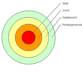
WA satellite village is a term for one or more settlements that have arisen within the outskirts of a larger one.
 W
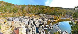
WA shut-in is a type of rock formation found in streams in the Ozarks, comprising pools, rivulets, rapids and plunge pools. The term has an origin in Appalachia.
 W
WA Sliver Polygon, in the context of Geographic Information Systems (GIS), is a small polygon found in vector data that is an artifact of error rather than representing a real-world feature. They have been a recognized source of error since overlay was first invented in the 1970s.
 W
WA snow field, snowfield or neve is an accumulation of permanent snow and ice, typically found above the snow line, normally in mountainous and glacial terrain.
 W
WSubterranea are underground structures, both natural and human-made. Some subterranea and related topics include:
 W
WTexhomex is a marker showing the tri-point of Oklahoma, Texas and New Mexico. The marker is off U.S. Highway 56 about one mile east on Texas State Line Road and the corner of Oklahoma State Line Road. There are no signs on Highway 56 in either direction.
 W
WIn France, an urban unit is a statistical area defined by INSEE, the French national statistics office, for the measurement of contiguously built-up areas. According to the INSEE definition, an "unité urbaine" is a commune alone or a grouping of communes which: a) form a single unbroken spread of urban development, with no distance between habitations greater than 200 m and b) have all together a population greater than 2,000 inhabitants. Communes not belonging to an unité urbaine are considered rural.
 W
WVinex, is a policy briefing note of the Dutch Ministry of Housing, Spatial Planning and the Environment released in 1991. Large outer city areas were pointed out by the policy for massive new housing development. Neighbourhoods built based on the note are known as Vinex-wijken.
 W
WA wind gap is a gap through which a waterway once flowed that is now dry as a result of stream capture. A water gap is a similar feature, but one in which a waterway still flows. Water gaps and wind gaps often provide routes which, due to their gently inclined profile, are suitable for trails, roads, and railroads through mountainous terrain.