 W
WThe 869 Sanriku earthquake and its associated tsunami struck the area around Sendai in the northern part of Honshu on 9 July 869 AD. The earthquake had an estimated magnitude of at least 8.4 on the moment magnitude scale, but may have been as high as 9.0, similar to the 2011 Tōhoku earthquake and tsunami. The tsunami caused widespread flooding of the Sendai plain. In 2001, researchers identified sand deposits in a trench more than 4.5 kilometres (2.8 mi) from the coast as coming from this tsunami.
 W
WThe 1420 Caldera earthquake shook the southern portion of Atacama Desert on September 1 and caused tsunamis in Chile as well as Hawaii and the towns of Japan. The earthquake is thought to have had a size of 8.8–9.4 Mw. Historical records of the tsunami exist for the Japanese harbours of Kawarago and Aiga where confused residents saw the water recede in the morning of September 1, without any sign of an earthquake. In Chile, landslides occurred along the coast as well.
 W
WThe 1498 Meiō earthquake occurred off the coast of Nankaidō, Japan, at about 08:00 local time on 20 September 1498. It had a magnitude estimated at 8.6 Ms and triggered a large tsunami. The death toll associated with this event is uncertain, but between 5,000 and 41,000 casualties were reported. The tsunami caused by the Meiō Nankaidō earthquake washed away the building housing the statue of the Great Buddha at Kōtoku-in in Kamakura, although the statue itself remained intact.
 W
WThe 1585 Aleutian Islands earthquake is the source of a vaguely–described tsunami along the Sanriku coast of Japan on June 11, 1585. The event was misdated to 1586 and thought to be generated by the 1586 Lima–Callao earthquake. The misdating also led to it being attributed with the deadly 1586 Tenshō earthquake. The source earthquake is now determined to be along the Aleutian Islands. Evidence from tsunami deposit and coral rocks in Hawaii led to the inference that this was a large megathrust earthquake occurring on the Aleutian subduction zone with a moment magnitude (Mw ) as large as 9.25.
WThe 1605 Keichō earthquake occurred at about 20:00 local time on 3 February. It had an estimated magnitude of 7.9 on the surface wave magnitude scale and triggered a devastating tsunami that resulted in thousands of deaths in the Nankai and Tōkai regions of Japan. It is uncertain whether there were two separate earthquakes separated by a short time interval or a single event. It is referred to as a tsunami earthquake, in that the size of the tsunami greatly exceeds that expected from the magnitude of the earthquake.
WThe 1611 Sanriku earthquake occurred on December 2, 1611, with an epicenter off the Sanriku coast in Iwate Prefecture. The magnitude of the earthquake was 8.1Ms. It triggered a devastating tsunami. A description of this event in an official diary from 1612 is probably the first recorded use of the term 'tsunami'.
WThe Bōsō Peninsula was struck by a major tsunami on 4 November 1677, caused by an earthquake at the southern end of the Japan Trench. It was felt onshore with only a maximum of 4 on the JMA intensity scale, but had an estimated magnitude of 8.3–8.6 Mw. The disparity between the maximum intensity and the magnitude estimated from the tsunami suggest that this was a tsunami earthquake. There no records of significant damage caused by the shaking, but the resulting tsunami caused widespread damage and an estimated 569 people were killed
 W
WThe 1700 Cascadia earthquake occurred along the Cascadia subduction zone on January 26, 1700, with an estimated moment magnitude of 8.7–9.2. The megathrust earthquake involved the Juan de Fuca Plate from mid-Vancouver Island, south along the Pacific Northwest coast as far as northern California. The length of the fault rupture was about 1,000 kilometers, with an average slip of 20 meters (66 ft).
 W
WThe 1703 Genroku earthquake occurred at 02:00 local time on December 31. The epicenter was near Edo, the forerunner of present-day Tokyo, in the southern part of the Kantō region, Japan. An estimated 2,300 people were killed by the shaking and subsequent fires. The earthquake triggered a major tsunami which caused many casualties, giving a total death toll of at least 5,233, possibly up to 10,000. Genroku is a Japanese era spanning from 1688 through 1704.
 W
WThe 1707 Hōei earthquake struck south-central Japan at 14:00 local time on 28 October. It was the largest earthquake in Japanese history until surpassed by the 2011 Tōhoku earthquake. It caused moderate to severe damage throughout southwestern Honshu, Shikoku and southeastern Kyūshū. The earthquake, and the resulting destructive tsunami, caused more than 5,000 casualties. This event ruptured all of the segments of the Nankai megathrust simultaneously, the only earthquake known to have done this, with an estimated magnitude of 8.6 ML or 8.7 Mw. It might also have triggered the last eruption of Mount Fuji 49 days later.
 W
WThe devastating eruption of Oshima–Ōshima began on the 18th of August, 1741 and ended on May 1 the next year. Eleven days into the eruption, the Kampo tsunami with estimated maximum heights of over 90 meters swept across neighboring islands in Japan and the Korean Peninsula.
 W
WThe 1771 Great Yaeyama Tsunami was caused by the Yaeyama Great Earthquake at about 8 A.M. on April 24, 1771, south-southeast of Ishigaki Island, part of the former Ryūkyū Kingdom and now forming part of present-day Okinawa, Japan. According to records, 8,439 persons were killed on Ishigaki Island and 2,548 on Miyako Island.
WThe 1837 Valdivia earthquake struck south-central Chile on November 17. Together with earthquakes in 1575 and 1737 the earthquake is among the historical predecessors to the great 1960 earthquake. The rupture zone was roughly from Valdivia to the south. It was felt in the cities of Concepción, Valdivia and Ancud. The earthquake was also felt by the crew whaling ships in Guafo Island and Chonos Archipelago. Various landslides were triggered in Chiloé and people are reported to have been thrown to the ground in Valdivia. In contrast in Concepción the shakings were moderate. As reported in various coastal localities the ground rose as result of the earthquake. Decades later while surveying southern Chile’s coasts Francisco Vidal Gormaz was told of islands that been submerged and some that had emerged as a consequence of the earthquake. The earthquake caused a tsunami that struck Hawaii, what is now French Polynesia and Japan.
 W
WThe 1854 Tōkai earthquake was the first of the Ansei great earthquakes (1854–1855). It occurred at about 09:00 local time on 23 December 1854. It had a magnitude of 8.4 and caused a damaging tsunami. More than 10,000 buildings were destroyed and there were at least 2,000 casualties.
WThe 1854 Nankai earthquake occurred at about 16:00 local time on 24 December. It had a magnitude of 8.4 and caused a damaging tsunami. More than 30,000 buildings were destroyed and there were at least 3,000 casualties.
 W
WThe 1877 Iquique earthquake occurred at 21:16 local time on 9 May. It had a magnitude of 8.5 on the surface wave magnitude scale. Other estimates of its magnitude have been as high as 8.9 Mw and 9.0 Mt. It had a maximum intensity of XI (Extreme) on the Mercalli intensity scale and triggered a devastating tsunami. A total of 2,385 people died, mainly in Fiji.
 W
WThe 1896 Sanriku earthquake was one of the most destructive seismic events in Japanese history. The 8.5 magnitude earthquake occurred at 19:32 on June 15, 1896, approximately 166 kilometres (103 mi) off the coast of Iwate Prefecture, Honshu. It resulted in two tsunamis which destroyed about 9,000 homes and caused at least 22,000 deaths. The waves reached a then-record height of 38.2 metres (125 ft); this would remain the highest on record until waves from the 2011 Tōhoku earthquake exceeded that height by more than 2 metres.
 W
WThe 1911 Kikai Island earthquake occurred on June 15 at 14:26 UTC. The earthquake was located near Kikai Island, Japan. It had a magnitude of Ms 8.1.
 W
WThe Great Kantō earthquake struck the Kantō Plain on the main Japanese island of Honshū at 11:58:44 JST on Saturday, September 1, 1923. Varied accounts indicate the duration of the earthquake was between four and ten minutes. Extensive firestorms and even a fire whirl added to the death toll. Racist civil unrest after the disaster has been documented.
WThe 1933 Sanriku earthquake occurred on the Sanriku coast of the Tōhoku region of Honshū, Japan on March 2 with a moment magnitude of 8.4. The associated tsunami caused widespread damage.
 W
WThe 1944 Tōnankai earthquake occurred at 13:35 local time on 7 December. It had an estimated magnitude of 8.1 on the moment magnitude scale and a maximum felt intensity of greater than 5 shindo. It triggered a large tsunami that caused serious damage along the coast of Wakayama Prefecture and the Tōkai region. Together the earthquake and tsunami caused 3,358 casualties.
WThe 1946 Nankai earthquake was a great earthquake in Nankaidō, Japan. It occurred on December 21, 1946, at 04:19 JST. The earthquake measured between 8.1 and 8.4 on the moment magnitude scale, and was felt from Northern Honshū to Kyūshū. It occurred almost two years after the 1944 Tōnankai earthquake, which ruptured the adjacent part of the Nankai megathrust.
WThe 1960 Valdivia earthquake and tsunami or the Great Chilean earthquake on 22 May 1960 was the most powerful earthquake ever recorded. Various studies have placed it at 9.4–9.6 on the moment magnitude scale. It occurred in the afternoon, and lasted for approximately 10 minutes. The resulting tsunamis affected southern Chile, Hawaii, Japan, the Philippines, eastern New Zealand, southeast Australia, and the Aleutian Islands.
 W
WThe 1964 Niigata earthquake struck at 13:01 local time on 16 June with a magnitude of either 7.5 or 7.6. The epicenter was on the continental shelf off the northwest coast of Honshu, Japan in Niigata Prefecture, about 50 kilometres (31 mi) north of the city of Niigata. The earthquake caused liquefaction over large parts of the city.
WThe 1973 Nemuro earthquake, also known as the Nemuro-Oki earthquake in scientific literature, occurred on June 17 at 11:55 local time. It stuck with an epicenter just off the Nemuro Peninsula in northern Hokkaidō, Japan. It measured 7.7 to 7.9 on the moment magnitude scale (Mw ), 8.1 on the tsunami magnitude scale (Mt ) and 7.4 on the Japan Meteorological Agency magnitude scale (MJMA ).
 W
WThe 1983 Sea of Japan earthquake occurred on May 26, 1983 at 11:59:57 local time. It had a magnitude of 7.8 on the moment magnitude scale. It occurred in the Sea of Japan, about 100 km west of the coast of Noshiro in Akita Prefecture, Japan. Out of the 104 fatalities, all but four were killed by the resulting tsunami, which struck communities along the coast, especially Aomori and Akita Prefectures and the east coast of Noto Peninsula. Images of the tsunami hitting the fishing harbor of Wajima on Noto Peninsula was broadcast on TV. The waves exceeded 10 meters (33 ft) in some areas. Three of the fatalities were along the east coast of South Korea. The tsunami also hit Okushiri Island, the site of a more deadly tsunami 10 years later.
 W
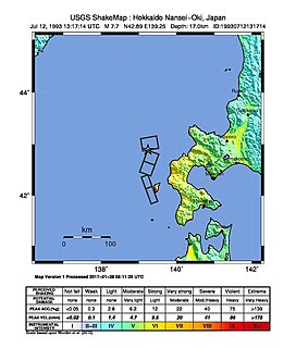
WThe 1993 southwest-off Hokkaido earthquake or Okushiri earthquake occurred at 13:17:12 UTC on 12 July 1993 in the Sea of Japan near the island of Hokkaido. It had a magnitude of 7.7 on the moment magnitude scale and a maximum felt intensity of VIII (Severe) on the Mercalli intensity scale. It triggered a major tsunami that caused deaths on Hokkaidō and in southeastern Russia, with a total of 230 fatalities recorded. The island of Okushiri was hardest hit, with 165 casualties from the earthquake, the tsunami and a large landslide.
 W
WThe 1994 offshore Sanriku earthquake occurred on December 28, 1994, at 12:19 UTC. This was a magnitude Mw 7.7 earthquake with epicenter located in the Pacific Ocean at about 180 km east of Hachinohe, Aomori. Three people were reported dead and more than 200 injured; 48 houses were completely destroyed. Road damage and power outages were reported. Liquefaction occurred in the Hachinohe Port area. The intensity reached shindo 6 in Hachinohe, Aomori, about 187.6 km from epicenter. It could be felt in Tokyo, about 632.9 km from epicenter, with shindo 2. The Japanese Meteorological Agency put the magnitude at MJMA 7.5. Slip associated with this earthquake continued for more than a year and it has been termed an 'ultra-slow earthquake'.
 W
WThe 2016 Fukushima earthquake struck Japan with a moment magnitude of 6.9 east-southeast of Namie, Fukushima Prefecture at 05:59 JST on November 22, at a depth of 11.4 km (7.1 mi). Fukushima is a very dense prefecture in Japan north of Tokyo, with a population of nearly 2 million. The shock had a maximum intensity of VII (Very strong) on the Mercalli scale. The earthquake was initially reported as a 7.3 magnitude by Japan Meteorological Agency, which was later upgraded to a 7.4, while the United States Geological Survey and GFZ Potsdam determined a magnitude of 6.9.
 W
WOn 14 January 2022, a very large eruption on Hunga Tonga–Hunga Haʻapai, an uninhabited volcanic island and submarine volcano of the Tongan archipelago in the southern Pacific Ocean, began. The eruption reached a powerful climax on the next day, 15 January. Hunga Tonga is 65 km (40 mi) north of Tongatapu, the country's main island, and is part of the highly active Tonga–Kermadec Islands volcanic arc, a subduction zone extending from New Zealand north-northeast to Fiji. The eruption caused tsunamis in Tonga, Fiji, American Samoa, Vanuatu, and along the Pacific rim, including damaging tsunamis in New Zealand, Japan, the United States, the Russian Far East, Chile, and Peru. At least three people were killed, some were injured, and many remain missing in Tonga from tsunami waves up to 15 m (49 ft) high. Two people drowned in Peru when a 2 m wave struck the coast. Preliminary data indicate that the event was probably the largest volcanic eruption recorded since the 1991 eruption of Mount Pinatubo. NASA determined that the eruption was "hundreds of times more powerful" than the first atomic bomb.
 W
WThe Ansei great earthquakes were a series of three major earthquakes that struck Japan during the Ansei era (1854–1860).The Ansei Tōkai quake was an 8.4 magnitude earthquake which struck on December 23, 1854. The epicenter ranged from Suruga Bay to the deep ocean, and struck primarily in the Tōkai region, but destroyed houses as far away as in Edo. The subsequent tsunami caused damage along the entire coast from the Bōsō Peninsula in modern-day Chiba prefecture to Tosa province The Ansei Nankai quake was an 8.4 magnitude earthquake which struck on December 24, 1854. Over 10,000 people from the Tōkai region down to Kyushu were killed. The Ansei Edo quake was a Ms 7.0 earthquake which struck Edo on November 11, 1855. ~120 earthquakes and tremors in total were felt in Edo in 1854-55. The great earthquake struck after 10 p.m.; roughly 30 aftershocks continued until dawn. The epicenter was near the mouth of the Arakawa River. Records from the time indicate 6,641 deaths inside the city, and 2,759 injuries; much of the city was destroyed by fire, leading many people to stay in rural inns. Aftershocks continued for ~20. This quake was a particularly destructive deep thrust quake caused by a giant slab of rock stuck between the Philippine Sea Plate and the Pacific Plate.
 W
WOn April 13, 1923 at 15:31 UTC, an earthquake occurred off the northern coast of the Kamchatka Peninsula in the USSR, present-day Russia. The earthquake had a surface wave magnitude (Ms ) of 6.8 to 7.3 and an estimated moment magnitude (Mw ) of ~8.0. This event came just two months after a slightly larger Mw 8.4 earthquake, with the epicenter south of the April event, struck the area. Both earthquakes were tsunamigenic although the latter generated wave heights far exceeding that of the one in February. After two foreshocks of "moderate force", the main event caused considerable damage. Most of the 36 casualties were the result of the tsunami inundation rather than the earthquake.
 W
WThe 1293 Kamakura earthquake in Japan occurred at about 06:00 local time on 27 May 1293. It had an estimated magnitude of 7.1–7.5 and triggered a tsunami. The estimated death toll was 23,024. It occurred during the Kamakura period, and the city of Kamakura was seriously damaged.
 W
WThe 1994 Kuril Islands earthquake – also known as the Hokkaido Toho-oki earthquake – occurred on October 5 at 00:23:00 local time. The magnitude of this earthquake was put at Mw8.3, or MJMA8.1. The epicenter was located at about 70 km east of Shikotan Island. The shaking and tsunami caused road and building damage. At least 10 people were reported dead.
 W
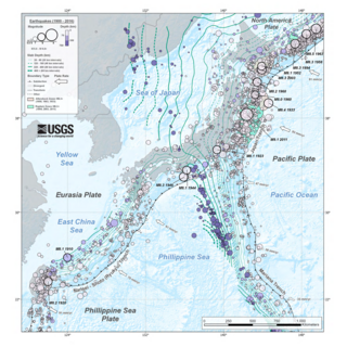
WThis is a list of earthquakes in Japan with either a magnitude greater than or equal to 7.0 or which caused significant damage or casualties. As indicated below, magnitude is measured on the Richter magnitude scale (ML) or the moment magnitude scale (Mw), or the surface wave magnitude scale (Ms) for very old earthquakes. The present list is not exhaustive, and reliable and precise magnitude data is scarce for earthquakes that occurred before the development of modern measuring instruments.
 W
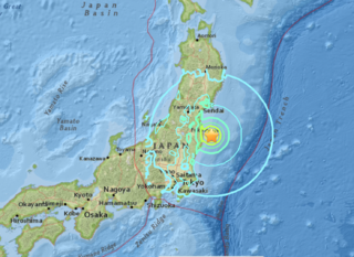
WThe 2011 Tōhoku earthquake and tsunami occurred at 14:46 JST on 11 March. The magnitude 9.0–9.1 (Mw) undersea megathrust earthquake had an epicenter in the Pacific Ocean, 72 km (45 mi) east of the Oshika Peninsula of the Tōhoku region, and lasted approximately six minutes, causing a tsunami. It is sometimes known in Japan as the "Great East Japan Earthquake" , among other names. The disaster is often referred to in both Japanese and English as simply 3.11.
 W
WThe 1792 Unzen earthquake and tsunami resulted from the volcanic activities of Mount Unzen on 21 May. This caused the collapse of the southern flank of the Mayuyama dome in front of Mount Unzen, resulting in a tremendous megatsunami, killing 15,000 people altogether. It was also called Shimabara erupted, Higo affected (島原大変肥後迷惑), since many people were killed by this tsunami in Higo.
 W
WMount Unzen is an active volcanic group of several overlapping stratovolcanoes, near the city of Shimabara, Nagasaki on the island of Kyushu, Japan's southernmost main island.