 W
WAn acequia or séquia is a community-operated watercourse used in Spain and former Spanish colonies in the Americas for irrigation. Particularly in Spain, the Andes, northern Mexico, and the modern-day American Southwest particularly northern New Mexico and southern Colorado, acequias are usually historically engineered canals that carry snow runoff or river water to distant fields. Examples of acequias in New Mexico have lengthy historical roots to Pueblo and Hispano communities, and they are incorporated into traditions including the matachines, life in the Rio Grande Bosque of the Albuquerque metropolitan area, and pilgrimages to El Santuario de Chimayo.
 W
WThe Acequia Madre, in Las Vegas, New Mexico, is a historic acequia which was built at the time of Las Vegas' settlement in 1835–36. It was listed on the National Register of Historic Places in 1987.
 W
WAcequia Madre de Valero is an 18th-century agricultural irrigation canal built by the Spanish and located in the Bexar County city of San Antonio in the U.S. state of Texas. When Martín de Alarcón founded San Antonio for Spain by establishing San Antonio de Valero Mission in 1718, Franciscan priest Antonio de Olivares and the Payaya people dug Acequia Madre de Valero by hand. It was vital to the missions to be able to divert and control water from the San Antonio River, in order to grow crops and to supply water to the people in the area. This particular acequia was the beginning of a much wider acequia system. Acequia Madre de Valero ran from the area currently known as Brackenridge Park and southward to what is now Hemisfair Plaza and South Alamo Street. Part of it that is not viewable by the public runs beneath the Menger Hotel. The acequia was restored in 1968 and that year was designated a Recorded Texas Historic Landmark.
 W
WThe American Canal is an irrigation canal in the Upper Rio Grande Valley near El Paso, Texas. The canal acquires water from the Rio Grande from the American Diversion Dam at the Texas–New Mexico–Mexico border, 2 miles (3.2 km) northwest of downtown El Paso. The canal supplies the majority of the raw water to El Paso’s Johnathan-Roger Water Treatment Plant. It also mitigates flooding in south El Paso neighborhoods. The canal travels along the Rio Grande for 2.1 miles (3.4 km) where it flows into the Franklin Canal and the rest of the canal network. Construction of the canal dates back to 1938.
 W
WThe Chandra Canal is an irrigation canal project established in the northeastern Saptari district of Nepal by Chandra Shumsher Jang Bahadur Rana, one of the Prime Ministers during the Rana era (1846–1951) of Nepal, was the first canal in the country. It is originated from the Triyuga river at Fattepur. The canal was constructed by the first engineer of Nepal, Dilli Jung Thapa.
 W
WThe El Barranco Community Ditch in Los Brazos, New Mexico is a 3.8 miles (6.1 km) long irrigation ditch diverting water from the Rio Chama. It was dug before 1907. It was listed on the National Register of Historic Places in 1986.
 W
WThe Franklin Canal is an irrigation canal in the Upper Rio Grande Valley near El Paso, Texas. The canal acquires water from the Rio Grande via the American Canal. The canal is 28.4 miles (45.7 km) long with a capacity of 325 cubic feet per second (9.2 m3/s).
 W
WThe Ganga Canal of Rajasthan is an irrigation system of canals laid down by Maharaja Ganga Singh of Bikaner in his princely state in the present district of Sri Ganganagar in the early twentieth century. It is fed from the Sutlej River near Firozpur, Punjab, close to the India–Pakistan border, and passes through the Faridkot and Muktsar districts. Faridkot's Jhok Sarkari village lies on its path.
 W
WThe Great Fergana Canal is an irrigation canal located on the Fergana Valley between Uzbekistan and Tajikistan in Central Asia. The project was constructed in 1939 by 160,000 Uzbek and Tajik collective farm workers from the former Soviet Union and was completed in forty-five days. The canal is 270 kilometers long with over 1,000 hydrotechnical plants located along the waterway, 50 of which are known to be significantly important.
 W
WThe Indira Gandhi Canal is the longest canal of India. It starts from the Harike Barrage at Harike, a few kilometers below the confluence of the Satluj and Beas rivers in the Indian state of Punjab and terminates in irrigation facilities in the Thar Desert in the north west of Rajasthan state. Previously known as the Rajasthan Canal, it was renamed the Indira Gandhi Canal on 2 November 1984 following the assassination of Prime Minister Indira Gandhi.
 W
WThe Irtysh–Karamay–Ürümqi Canal, also known as the Project 635 Canal, is a system of water-transfer canals and reservoirs in the northern part of China's Xinjiang Uighur Autonomous Region. It transfers water from the Irtysh River into several dry endorheic basins of north-central Xinjiang, where it is used for irrigation and general use of the population and industries.
 W
WThe Karakum Canal in Turkmenistan is one of the largest irrigation and water supply canals in the world. Started in 1954, and completed in 1988, it is navigable over much of its 1,375-kilometre (854 mi) length, and carries 13 cubic kilometres (3.1 cu mi) of water annually from the Amu-Darya River across the Karakum Desert in Turkmenistan. The canal opened up huge new tracts of land to agriculture, especially to cotton monoculture heavily promoted by the Soviet Union, and supplying Ashgabat with a major source of water. The canal is also a major factor leading to the Aral Sea environmental disaster. The Soviet regime planned to at some time extend the canal to the Caspian Sea.
WThe La Puente Community Ditch, through La Puente, New Mexico, is a 2 miles (3.2 km) long irrigation ditch which was listed on the National Register of Historic Places in 1986.
 W
WThe Canal Lauca is an artificial channel to divert the waters of the Lauca River westward through a canal and tunnel into the Azapa Valley for purposes of irrigation in the valley and hydroelectric-power generation. Its construction began 1948 and water diversion began 14 years later from a dam located about 16 miles southwest of Lago Cotacotani Lake.
 W
WA levada is an irrigation channel or aqueduct specific to the Portuguese Atlantic region of Madeira.
WThe Lower Animas Ditch, in Aztec, New Mexico, was listed on the National Register of Historic Places in 1987.
 W
WThe Main Turkmen Canal was a large-scale irrigation project in the Turkmen Soviet Socialist Republic. The canal was intended to transport water from the Amu Darya river to Krasnovodsk, a city in Turkmenistan on the coast of the Caspian Sea. The canal was going to use the course of the ancient dry Uzboy River bed.
 W
WCanal Mauri is a canal in Peru and Chile. It transfers water from the Mauri River watershed and transfers it into the Caplina River for irrigation purposes. An earlier canal Canal Uchusuma was constructed in the early 19th century and was replaced by the Canal Mauri. This canal collects water from several tributaries of the Mauri River and diverts it through Chilean territory into the Quebrada Vilavilani, a tributary of the Caplina River; from there it is later diverted for irrigation purposes in the Tacna region.
 W
WThe Mill Creek Zanja, also known as the Sankey, is a historic irrigation canal, or zanja, in Redlands, California. The Serrano people dug the canal in 1819 to provide water from Mill Creek for their farms east of the city. The zanja also provided water for the San Bernardino de Sena Estancia mission outpost, which was built near the canal to access its water. The canal's water became a highly desirable resource in the area; it fueled a local agricultural boom and was the subject of several legal disputes over water rights in the 1800s. The City of Redlands covered the western half of the zanja in the 1920s.
 W
WNai Gaj is an ephemeral river in Dadu District of Sindh, Pakistan. The Government of Pakistan build the Nai Gaj Dam on its course. Nai Gaj drains part of the Kirthar Mountains, and flows from Balochistan province towards Sindh. It ends at Lake Manchar after flowing through the arid areas of Kachho in Dadu District.
 W
WNicosia old aqueduct is located in Nicosia, the capital of Cyprus and is the oldest aqueduct in Cyprus. It is located close to Eleftheria (Liberty) Monument in Nicosia.
 W
WThe North Crimean Canal is a land improvement canal for irrigation and watering of Kherson Oblast in southern Ukraine, and the Crimean Peninsula. The canal also has multiple branches throughout Kherson Oblast and the Crimean Peninsula.
 W
WThe Onna-bori (女堀) was an irrigation canal dating the from Heian period, the remnants of which are located in what is now the cities of Maebashi, and Isesaki Gunma Prefecture in the northern Kantō region of Japan. The six surviving disconnected portions were collectively designated a National Historic Site of Japan in 1983.
 W
WPehur High Level Canal located in Swabi District, Khyber Pakhtunkhwa, Pakistan.
 W
WThe Rangitata Diversion Race or RDR is a combined irrigation and power generation scheme that diverts water from the Rangitata River to irrigate over 100,000 hectares of farmland in Mid-Canterbury, New Zealand.The RDR project was the first major river diversion in New Zealand, and the largest irrigation scheme in the country. It was originally constructed by the Public Works Department between 1937 and 1944. The main canal is 67 km long, 10 m wide and 3 m deep.
 W
WThe Red Flag Canal is an irrigation canal located 80 km (50 mi) northwest of Anyang in the northern extremity of Henan, China.
 W
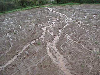
WIn hillslope geomorphology, a rill is a shallow channel cut into soil by the erosive action of flowing water. Similar but smaller incised channels are known as microrills; larger incised channels are known as gullies.
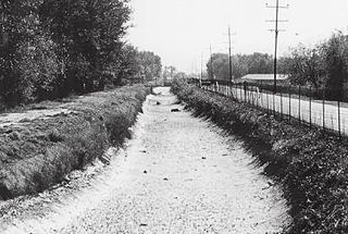
WThe Riverside Canal is an irrigation canal in El Paso County beginning southeast of El Paso, Texas. The canal acquires water from the Riverside Diversion Dam on the Rio Grande 15 miles (24 km) southeast of El Paso. The canal is managed by the US Bureau of Reclamation. The canal extends for 17.2 miles (27.7 km) with a capacity of 900 cubic feet per second. Water from the canal irrigates about 39,000 acres (160 km²). The canal and diversion dam is the southernmost system on an irrigation project extending along the Rio Grande in New Mexico and Texas. The canal supplies a canal network extending throughout the Upper Rio Grande Valley.
 W
WThe San Buenaventura Mission Aqueduct was a seven-mile long, stone and mortar aqueduct built in the late 18th and/or early 19th century to transport water from the Ventura River to the Mission San Buenaventura in Ventura, California.
 W
WSmith's Irrigation Ditch, originally the Big Ditch and also known as the City Ditch is a historic ditch primarily visible in Washington Park, Denver, Colorado. It is listed on the National Register of Historic Places.
 W
WSteamboat Ditch is a roughly 34-mile-long irrigation canal dug in the late 1870s by Chinese laborers. It begins at the Nevada and California state line and joins Steamboat Creek in south Reno.
 W
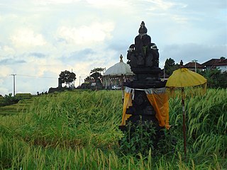
WSubak is the water management (irrigation) system for the paddy fields on Bali island, Indonesia. It was developed in the 9th century. For the Balinese, irrigation is not simply providing water for the plant's roots, but water is used to construct a complex, pulsed artificial ecosystem. The system consists of five terraced rice fields and water temples covering nearly 20,000 hectares. The temples are the main focus of this cooperative water management, known as subak.
 W
WTexas has many irrigation canals with the majority of large canal networks in the Rio Grande Valley and the Gulf Coast, though smaller systems are located throughout the state. Canals provide water to dry climates to irrigate crops.
WCanal Uchusuma is a canal in Chile.
 W
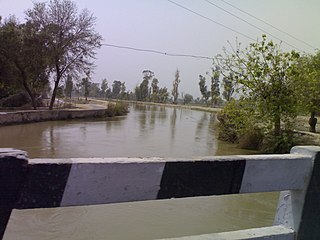
WThe Upper Jhelum Canal is an irrigation canal in Pakistan that provides water to 1.8 million acres of farmland.
 W
WThe Zanja Madre is the original aqueduct that brought water to the Pueblo de Los Angeles from the Río Porciúncula. The original open, earthen ditch was completed by community laborers within a month of founding the pueblo. This water system was used for both domestic uses and irrigation to fields west of town. This availability of water was essential to the survival and growth of the community founded here. Brick conduits 3 to 3.5 feet in diameter were built to improve the system after 1884. Eventually the system did not supply enough water to keep pace with population growth and irrigation demand. The system was abandoned by 1904 though portions were still used for storm water purposes. It was maintained by the Zanjero of Los Angeles.