 W
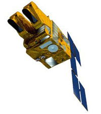
WThe Anik satellites are a series of geostationary communications satellites launched for Telesat Canada for television, voice and data in Canada and other parts of the world, from 1972 through 2013. Some of the later satellites in the series remain operational in orbit, while others have been retired to a graveyard orbit. The naming of the satellite was determined by a national contest, and was won by Julie-Frances Czapla of Saint-Léonard, Québec. In Inuktitut, Anik means "little brother".
 W
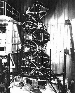
WThe CORONA program was a series of American strategic reconnaissance satellites produced and operated by the Central Intelligence Agency (CIA) Directorate of Science & Technology with substantial assistance from the U.S. Air Force. The CORONA satellites were used for photographic surveillance of the Soviet Union (USSR), China, and other areas beginning in June 1959 and ending in May 1972.
 W
WThe Defense Meteorological Satellite Program (DMSP) monitors meteorological, oceanographic, and solar-terrestrial physics for the United States Department of Defense. The program is managed by the United States Space Force with on-orbit operations provided by the National Oceanic and Atmospheric Administration (NOAA). The mission of the satellites was revealed in March 1973. They provide cloud cover imagery from polar orbits that are Sun-synchronous at nominal altitude of 830 km (520 mi).
 W
WElektro–L is a next-generation series of meteorological satellites developed for the Russian Federal Space Agency by NPO Lavochkin. The first satellite, Elektro-L No.1, was launched on 2 January 2011. It is the first Russian weather satellite that successfully operates in geostationary orbit, and is currently the second operational Russian weather satellite. The satellites have a mass of about 1620 kg and are designed to operate for 10 years each. They are capable of producing images of the Earth's whole hemisphere in both visible and infrared frequencies, providing data for climate change and ocean monitoring in addition to their primary weather forecasting role.
 W
WElektron ('electron'), in American sources sometimes called Electron, was the first Soviet multiple satellite program, comprising two identical pairs of particle physics satellites launched by the Soviet Union in 1964. The four spacecraft simultaneously monitored the lower and upper Van Allen radiation belts and returned a considerable volume of data regarding radiation in space and atmospheric conditions to an altitude of more than 58,000 kilometres (36,000 mi) above the Earth. Two of the four launched satellites are still in orbit as of 2020, the other two having reentered.
 W
WEarth Resources Observation Satellite (EROS) is a series of Israeli commercial Earth observation satellites, designed and manufactured by Israel Aircraft Industries (IAI), with optical payload supplied by El-Op. The satellites are owned and operated by ImageSat International (ISI), another Israeli company, with some 35 full-time employees. EROS A was launched on December 5, 2000 and EROS B on April 25, 2006.
 W
WThe Gravity Recovery and Climate Experiment (GRACE) was a joint mission of NASA and the German Aerospace Center (DLR). Twin satellites took detailed measurements of Earth's gravity field anomalies from its launch in March 2002 to the end of its science mission in October 2017. The Gravity Recovery and Climate Experiment Follow-On (GRACE-FO) is a continuation of the mission on near-identical hardware, launched in May 2018.
 W
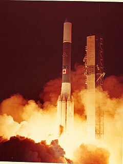
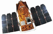
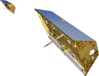
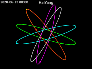
WHaiYang, abbreviated as HY, is a series of marine remote sensing satellites developed and operated by China since 2002. As of May 2021, eight satellites were launched and two more are planned.
 W
WThe Initial Defense Communications Satellite Program or IDCSP was the first United States Department of Defense communications satellite constellation and the first stage of the Defense Communications Satellite Program (DCSP). Launched in five groups by Titan IIIC launch vehicles to near equatorial, subsynchronous orbits between 1966 and 1968, they were intended to be experimental testbeds. They were so successful that, by the time of the launch of the last set of eight satellites, the IDCSP was deemed operational and renamed Initial Defense Satellite Communications System or IDSCS. This system allowed real-time collection of battlefield intelligence during the Vietnam War. A total of 35 IDCSP satellites were launched, 27 successfully.
 W
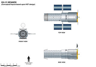
WThe KH-11 KENNEN is a type of reconnaissance satellite first launched by the American National Reconnaissance Office in December 1976. Manufactured by Lockheed in Sunnyvale, California, the KH-11 was the first American spy satellite to use electro-optical digital imaging, and so offer real-time optical observations.
 W
WLacrosse or Onyx is a series of terrestrial radar imaging reconnaissance satellites operated by the United States National Reconnaissance Office (NRO). While not officially confirmed by the NRO or the Government of the United States prior to 2008, there was widespread evidence pointing to its existence, including one NASA website. In July 2008, the NRO itself declassified the existence of its synthetic aperture radar (SAR) satellite constellation.
 W
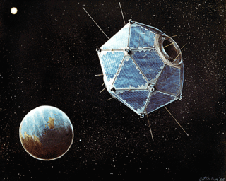
WLAGEOS, Laser Geodynamics Satellite or Laser Geometric Environmental Observation Survey, are a series of two scientific research satellites designed to provide an orbiting laser ranging benchmark for geodynamical studies of the Earth. Each satellite is a high-density passive laser reflector in a very stable medium Earth orbit (MEO).
 W
WThe Lincoln Experimental Satellite series was designed and built by Lincoln Laboratory at Massachusetts Institute of Technology between 1965 and 1976, under USAF sponsorship, for testing devices and techniques for satellite communication.
 W
WThe Meteor spacecraft are weather observation satellites launched by the Soviet Union and Russia. The Meteor satellite series was initially developed during the 1960s. The Meteor satellites were designed to monitor atmospheric and sea-surface temperatures, humidity, radiation, sea ice conditions, snow-cover, and clouds.
 W
WMetop is a series of three polar-orbiting meteorological satellites developed by the European Space Agency (ESA) and operated by the European Organisation for the Exploitation of Meteorological Satellites (EUMETSAT). The satellites form the space segment component of the overall EUMETSAT Polar System (EPS), which in turn is the European half of the EUMETSAT / NOAA Initial Joint Polar System (IJPS). The satellites carry a payload comprising 11 scientific instruments and two which support Cospas-Sarsat Search and Rescue services. In order to provide data continuity between Metop and NOAA Polar Operational Environmental Satellites (POES), several instruments are carried on both fleets of satellites.
 W
WThe Molniya series satellites are military and communications satellites launched by the Soviet Union from 1965 to 2004. These satellites use highly eccentric elliptical orbits known as Molniya orbits, which have a long dwell time over high latitudes. They are suited for communications purposes in polar regions, in the same way that geostationary satellites are used for equatorial regions.
 W
WThe Naval Ocean Surveillance System (NOSS) is a series of signals intelligence satellites that have conducted electronic signals intelligence for the U.S. Navy since the early 1970s. The first series of satellites were codenamed "White Cloud" or "PARCAE", while second and third-generation satellites have used the codenames "Ranger" and "Intruder".
 W
WNilesat is an Egyptian company and the name of a series of Egyptian communications satellites. It was established in 1996 with the purpose of operating Egyptian satellites and their associated mission control center and ground stations. The company is owned by the Egyptian Radio & Television Union with a 40 per cent share, the Arab Organization for Industrialization with a 10 per cent share, the Egyptian Company for Investment Projects with a 9 per cent share and the rest is owned by the general public, Egyptian financial institutions and other investors. The company has two ground stations, a primary one in 6th of October City and a secondary ground station in Alexandria. The two ground stations were built by EADS Astrium. Nilesat operates multiple geosynchronous communications satellites all of which are stationed at 7 degrees West. Nilesat includes as of 18 January 2008 415 video channels, 300 of which are free-to-air.
 W
WThe Nimbus satellites were second-generation U.S. robotic spacecraft launched between 1964 and 1978 used for meteorological research and development. The spacecraft were designed to serve as stabilized, Earth-oriented platforms for the testing of advanced systems to sense and collect atmospheric science data. Seven Nimbus spacecraft have been launched into near-polar, sun-synchronous orbits beginning with Nimbus 1 on August 28, 1964. On board the Nimbus satellites are various instrumentation for imaging, sounding, and other studies in different spectral regions. The Nimbus satellites were launched aboard Thor-Agena rockets and Delta rockets.
 W
WProton ('proton') was a Soviet series of four cosmic ray and elementary particle detecting satellites. Orbited 1965–68, three on test flights of the UR-500 ICBM and one on a Proton-K rocket, all four satellites completed their missions successfully, the last reentering the Earth's atmosphere in 1969.
 W
WRISAT is a series of Indian radar imaging reconnaissance satellites built by ISRO. They provide all-weather surveillance using synthetic aperture radars (SAR).
 W
WThe SAMOS or SAMOS-E program was a relatively short-lived series of reconnaissance satellites for the United States in the early 1960s, also used as a cover for the initial development of the KH-7 GAMBIT system. Reconnaissance was performed with film cameras and television surveillance from polar low Earth orbits with film canister returns and transmittals over the United States. SAMOS was first launched in 1960 from Vandenberg Air Force Base.
 W
WSentinel-3 is an Earth observation satellite series developed by the European Space Agency as part of the Copernicus Programme. It currently consists of 2 satellites: Sentinel-3A and Sentinel-3B. After initial commissioning, each satellite was handed over to EUMETSAT for the routine operations phase of the mission. Two recurrent satellites— Sentinel-3C and Sentinel-3D— will follow in approximately 2024 and 2028 respectively to ensure continuity of the Sentinel-3 mission.
 W
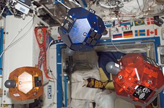
WThe Synchronized Position Hold Engage and Reorient Experimental Satellite (SPHERES) are a series of miniaturized satellites developed by MIT's Space Systems Laboratory for NASA and US Military, to be used as a low-risk, extensible test bed for the development of metrology, formation flight, rendezvous, docking and autonomy algorithms that are critical for future space missions that use distributed spacecraft architecture, such as Terrestrial Planet Finder and Orbital Express.
 W
WSPOT is a commercial high-resolution optical Earth imaging satellite system operating from space. It is run by Spot Image, based in Toulouse, France. It was initiated by the CNES in the 1970s and was developed in association with the SSTC and the Swedish National Space Board (SNSB). It has been designed to improve the knowledge and management of the Earth by exploring the Earth's resources, detecting and forecasting phenomena involving climatology and oceanography, and monitoring human activities and natural phenomena. The SPOT system includes a series of satellites and ground control resources for satellite control and programming, image production, and distribution. Earlier satellites were launched using the European Space Agency's Ariane 2, 3, and 4 rockets, while SPOT 6 and SPOT 7 were launched by the Indian PSLV.
 W
WThe STARSHINE series of three artificial satellites were student participatory missions sponsored by the United States Naval Research Laboratory.
 W
WDuring the second half of 2002, the Naval Research Laboratory studied the tactical application of space assets. Relatively new technologies and processes in the areas of microsatellites, affordable and quick-response launch vehicles, and the classified SIPRNet made tactical use of space assets possible in the relatively near term. The DoD's Office of Force Transformation (OFT) agreed with the core findings of the study and decided to start an Operationally Responsive Space (ORS) Initiative consisting of a series of experiments. TacSat-1 is the first experiment in this OFT initiative. The TacSat-1 experiment received go-ahead on 7 May 2003.
 W
WVela was the name of a group of satellites developed as the Vela Hotel element of Project Vela by the United States to detect nuclear detonations to monitor compliance with the 1963 Partial Test Ban Treaty by the Soviet Union.
 W
WZenit was a series of military photoreconnaissance satellites launched by the Soviet Union between 1961 and 1994. To conceal their nature, all flights were given the public Kosmos designation.