 W
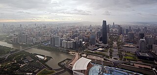
WUrbanization refers to the population shift from rural to urban areas, the corresponding decrease in the proportion of people living in rural areas, and the ways in which societies adapt to this change. It is predominantly the process by which towns and cities are formed and become larger as more people begin living and working in central areas.
 W
WIn France, the term banlieue refers to a suburb of a large city. Banlieues are divided into autonomous administrative entities and do not constitute part of the city proper. For instance, 80% of the inhabitants of the Paris Metropolitan Area live outside the city of Paris.
 W
WA commuter town is a populated area that is primarily residential, rather than commercial or industrial. Routine travel from home to work and then from work to home is called commuting, which is where the term comes from. A commuter town may be called by many other terms: "bedroom community", "bedroom town", "bedroom suburb" (US), "dormitory town", "dormitory suburb" or "dormitory village" (Britain/Commonwealth/Ireland). In Japan, a commuter town may be referred to with the wasei-eigo coinage "bed town" . The term "exurb" was also used from the 1950s, but since 2006, is generally used for areas beyond suburbs and specifically less densely built than the suburbs to which the exurbs' residents commute.
 W
WA conurbation is a region comprising a number of metropolises, cities, large towns, and other urban areas that, through population growth and physical expansion, have merged to form one continuous urban or industrially developed area. In most cases, a conurbation is a polycentric urbanised area, in which transportation has developed to link areas to create a single urban labour market or travel to work area.
 W
WIn urban planning, a core city, metropolitan core, or central city, is the largest or most important city of a metropolitan area. A core city is surrounded by smaller satellite cities, towns, and suburbs. A central city is usually the first settlement established in an urban region before the outlying districts came into existence, later in history. Central cities often form the regional downtowns of metro areas. The term is used mainly in US context, although since the 1970s it has also become relatively common in Canada and, to a lesser extent, Europe and Australia.
 W
WDawnsong is a public artwork by American artist Brose Partington, located at Indianapolis Art Center in Indianapolis, Indiana, United States. Dawnsong was installed as part of the Center's ARTSPARK initiative.
 W
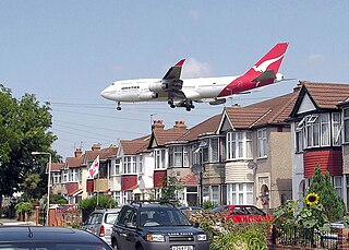
WThe day–evening–night noise level or Lden is a 2002 European standard to express noise level over an entire day. It imposes a penalty on sound levels during evening and night and it is primarily used for noise assessments of airports, busy main roads, main railway lines and in cities over 100,000 residents. The penalty for sound production during evenings and nights is due to higher nuisance perception during quieter hours and to prevent sleep deprivation for nearby residents.
 W
WEdge city is a term that originated in the United States for a concentration of business, shopping, and entertainment outside a traditional downtown or central business district, in what had previously been a suburban residential or rural area. The term was popularized by the 1991 book Edge City: Life on the New Frontier by Joel Garreau, who established its current meaning while working as a reporter for The Washington Post. Garreau argues that the edge city has become the standard form of urban growth worldwide, representing a 20th-century urban form unlike that of the 19th-century central downtown. Other terms for these areas include suburban activity centers, megacenters, and suburban business districts. These districts have now developed in many countries.
 W
WEnvironment & Urbanization is a biannual peer-reviewed academic journal covering urban and environmental studies. It is published by Sage Publications and was established in 1989. Each issue of the journal focuses on a particular theme.
 W
WAn exurb is an area outside the typically denser inner suburban area of a metropolitan area, which has an economic and commuting connection to the metro area, low housing density, and growth. It shapes an interface between urban and rural landscapes holding an urban nature for its functional, economic, and social interaction with the urban center, due to its dominant residential character. They consist of "agglomerations of housing and jobs outside the municipal boundaries of a primary city" and beyond its suburbs.
 W
WA Greater city movement refers to various reform efforts—both contemporary and historical—to expand the municipal boundaries of a primate central city to incorporate all, or part, of the surrounding metropolitan population. Historically, greater city movements were proposed as a solution to the problem of metropolitan planning and administration. Today, the concept has been largely discredited for political reasons Historically, examples of cities that have successfully expanded their boundaries to include the entire metropolitan population are extremely rare, and as a general principle few, if any cities worldwide have been able to maintain a continuous process of boundary adjustment to include surrounding areas of population growth.
 W
WStep migration is a migration pattern conceptualized in 1885 by Ernst Georg Ravenstein who observed migration as occurring stage by stage as rural inhabitants move closer to urban areas of growth. It is a migration pattern regarded by some scholars to be a widely popular form of international migration in the twenty-first century globalized world. There is a large breadth of study proving the existence of step migration in many international migration patterns, although there is lack of consensus over its exact specification and measurement. Step migration scholars deem it to be an important international trend that has the power to aid in the design of policy development efforts in both rural and urban areas worldwide. According to Abrahm Lustgarten, Senior Environmental Reporter for ProPublica, in his May 2021 report, Step migration -- or "stepwise migration" -- is a characteristic migration pattern of\\driven by climate change.
 W
WThe Agricultural Reserve is a designated land use zone in Montgomery County, Maryland. The 93,000 acres (380 km2) zone was created in 1980 by the Montgomery County Council to preserve farm land and rural space in the northwestern part of the county. The farmland protection program has been characterized as "the most famous, most studied and most emulated" program of its kind in the United States.
 W
WNoise pollution, also known as environmental noise or sound pollution, is the propagation of noise with ranging impacts on the activity of human or animal life, most of them harmful to a degree. The source of outdoor noise worldwide is mainly caused by machines, transport, and propagation systems. Poor urban planning may give rise to noise disintegration or pollution, side-by-side industrial and residential buildings can result in noise pollution in the residential areas. Some of the main sources of noise in residential areas include loud music, transportation, lawn care maintenance, construction, electrical generators, wind turbines, explosions, and people.
 W
WPeri-urbanisation relates to those processes of dispersive urban growth that create hybrid landscapes of fragmented urban and rural characteristics.
 W
WA reverse commute is a round trip, regularly taken, from an urban area to a suburban one in the morning, and returning in the evening. It is almost universally applied to trips to work in the suburbs from homes in the city. This is in opposition to the regular commute, where a person lives in the suburbs and travels to work in the city.
 W
WThe rural–urban fringe, also known as the outskirts, rurban, peri-urban or the urban hinterland, can be described as the "landscape interface between town and country", or also as the transition zone where urban and rural uses mix and often clash. Alternatively, it can be viewed as a landscape type in its own right, one forged from an interaction of urban and rural land uses.
 W
WSatellite cities or satellite towns are smaller municipalities that are adjacent to a major city which is the core of a metropolitan area. They differ from mere suburbs, subdivisions and especially bedroom communities in that they have municipal governments distinct from that of the core metropolis and employment bases sufficient to support their residential populations. Conceptually, satellite cities could be self-sufficient communities outside of their larger metropolitan areas. However, functioning as part of a metropolis, a satellite city experiences cross-commuting.
 W
WSuburbanization is a population shift from central urban areas into suburbs, resulting in the formation of (sub)urban sprawl. As a consequence of the movement of households and businesses out of the city centers, low-density, peripheral urban areas grow.
 W
WTenement housing in Chicago was established in the late 19th and into the early 20th centuries. A majority of tenement complexes in Chicago were constructed in the interest of using land space and boosting the economy. These tenements were built quite tall, often exceeding 3 stories, to accommodate as many low-income tenants as possible. This was possible as Chicago had not set a height limit to residential buildings, allowing landlords to create towering, cramped buildings with many rooms to generate as much revenue as possible. By the beginning of the 20th century, tenement housing in Chicago was generally divided based on ethnicity, including sections such as Polish, African American, Italian, and Greek ethnic neighborhoods.
 W
WThe UN-Habitat Scroll of Honour Award was created by the United Nations Centre for Human Settlements (UNCHS) in 1989 to encourage and recognize the countries, governments, organizations, and individuals who have made great contributions to the development of housing. It is the most prestigious human settlements award in the world by the United Nations, given by the United Nations Human Settlements Programme (UN-Habitat), and has recognized 192 initiatives since its launch in 1989.
 W
WUrban geography is the subdiscipline of geography that derives from a study of cities and urban processes. Urban geographers and urbanists examine various aspects of urban life and the built environment. Scholars, activists, and the public have participated in, studied, and critiqued flows of economic and natural resources, human and non-human bodies, patterns of development and infrastructure, political and institutional activities, governance, decay and renewal, and notions of socio-spatial inclusions, exclusions, and everyday life.
 W
WAn urban heat island (UHI) is an urban area or metropolitan area that is significantly warmer than its surrounding rural areas due to human activities. The temperature difference is usually larger at night than during the day, and is most apparent when winds are weak. UHI is most noticeable during the summer and winter. The main cause of the urban heat island effect is from the modification of land surfaces. Waste heat generated by energy usage is a secondary contributor. As a population center grows, it tends to expand its area and increase its average temperature. The term heat island is also used; the term can be used to refer to any area that is relatively hotter than the surrounding, but generally refers to human-disturbed areas.
 W
WUrban Indians are American Indians and Canadian First Nations peoples who live in urban areas. Urban Indians represent a growing proportion of the Native population in the United States. The National Urban Indian Family Coalition (NUIFC) considers the term to apply to "individuals of American Indian and Alaska Native ancestry who may or may not have direct and/or active ties with a particular tribe, but who identify with and are at least somewhat active in the Native community in their urban area."
 W
WUrban runoff is surface runoff of rainwater, landscape irrigation, and car washing created by urbanization. Impervious surfaces are constructed during land development. During rain storms and other precipitation events, these surfaces, along with rooftops, carry polluted stormwater to storm drains, instead of allowing the water to percolate through soil. This causes lowering of the water table and flooding since the amount of water that remains on the surface is greater. Most municipal storm sewer systems discharge stormwater, untreated, to streams, rivers and bays. This excess water can also make its way into people's properties through basement backups and seepage through building wall and floors.
 W
WUrban sprawl is the unrestricted growth in many urban areas of housing, commercial development, and roads over large expanses of land, with little concern for urban planning. In addition to describing a special form of urbanization, the term also relates to the social and environmental consequences associated with this development. Since the advent of the industrial era, sprawl has entailed no direct disadvantages, such as the loss of protection from medieval city walls. However, its disadvantages and costs include increased travel time, transport costs, pollution, and destruction of countryside. The cost of building the infrastructure needed for new developments is hardly ever recouped through property taxes, amounting to a huge subsidy for the developers and new residents at the expense of existing property taxpayers. In Continental Europe, the term peri-urbanisation is often used to denote similar dynamics and phenomena, but the term urban sprawl is currently being used by the European Environment Agency. There is widespread disagreement about what constitutes sprawl and how to quantify it. For example, some commentators measure sprawl only with the average number of residential units per acre in a given area, but others associate it with decentralization, discontinuity, segregation of uses, and so forth.
 W
WThis is a list of countries by urbanization.
 W
WWeighted urban proliferation (WUP) is a method used for measuring urban sprawl. This method, first introduced by Jaeger et al. (2010), calculates and presents the degree of urban sprawl as a numeric value. The method is based on the premise that as the built-over area in a given landscape increases, and the more dispersed this built-up area becomes, and the higher the uptake of this built-up area per inhabitant or job increases, the higher the overall degree of urban sprawl.