 W
WPermafrost is ground that continuously remains below 0 °C (32 °F) for two or more years, located on land or under the ocean. Permafrost does not have to be the first layer that is on the ground. It can be from an inch to several miles deep under the Earth's surface. Some of the most common permafrost locations are in the Northern Hemisphere. Around 15% of the Northern Hemisphere or 11% of the global surface is underlain by permafrost, including substantial areas of Alaska, Greenland, Canada and Siberia. It can also be located on mountaintops in the Southern Hemisphere and beneath ice-free areas in the Antarctic. Permafrost frequently occurs in ground ice, but it can also be present in non-porous bedrock. Permafrost is formed from ice holding various types of soil, sand, and rock in combination.
 W
WIn environments containing permafrost, the active layer is the top layer of soil that thaws during the summer and freezes again during the autumn. In all climates, whether they contain permafrost or not, the temperature in the lower levels of the soil will remain more stable than that at the surface, where the influence of the ambient temperature is greatest. This means that, over many years, the influence of cooling in winter and heating in summer will decrease as depth increases.
 W
WAlas is a shallow depression which occurs primarily in Yakutia, which is formed by subsidence of the Arctic permafrost owing to repeated melting and refreezing. An alas first develops as a shallow lake as melt water fills the depression. The lake eventually dries out and is replaced by grasses and other herbaceous vegetation.
 W
WArctic methane release is the release of methane from seas and soils in permafrost regions of the Arctic. While it is a long-term natural process, methane release is exacerbated by global warming. This results in a positive feedback cycle, as methane is itself a powerful greenhouse gas.
 W
WThe Batagaika crater is a thermokarst depression in the Chersky Range area. The biggest permafrost crater in the world, it administratively belongs to the Sakha Republic Russia and is in its Verkhoyansky District.
 W
WBaydzharakh, a term based in the Yakut language, is a roughly cone-shaped natural rock formation. They are usually composed of siltstone, silty peat or loam.
 W
WMax Clifton Brewer (1924–2012) was an Arctic scientist, geophysicist, geological engineer, environmentalist, educator, and philosopher, and is best known for his expertise in the scientific field of permafrost. He was the longest-serving director (1956-1971) of the Naval Arctic Research Laboratory (NARL) in Utqiaġvik, Alaska where he established and managed the NARL ice stations in the Arctic Ocean. From 1971-1974 he served in the gubernatorial cabinet of William A. Egan as the first commissioner of the Alaska Department of Environmental Conservation.
 W
WIn gelisols, cryoturbation refers to the mixing of materials from various horizons of the soil down to the bedrock due to freezing and thawing.
 W
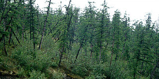
WDrunken trees, tilted trees, or a drunken forest, is a stand of trees rotated from their normal vertical alignment.
 W
WA frost boil, also known as mud boils, a stony earth circles, frost scars, or mud circles, are small circular mounds of fresh soil material formed by frost action and cryoturbation. They are found typically found in periglacial or alpine environments where permafrost is present, and may damage roads and other man-made structures. They are typically 1 to 3 metres in diameter.
 W
WGelisols are an order in USDA soil taxonomy. They are soils of very cold climates which are defined as containing permafrost within two meters of the soil surface. The word "Gelisol" comes from the Latin gelare meaning "to freeze", a reference to the process of cryoturbation that occurs from the alternating thawing and freezing characteristic of Gelisols.
The Global Terrestrial Network for Permafrost (GTN‐P) is the primary international programme concerned with monitoring permafrost parameters. GTN‐P was developed in the 1990s by the International Permafrost Association (IPA) under the Global Climate observing System (GCOS) and the Global Terrestrial Observing Network (GTOS), with the long-term goal of obtaining a comprehensive view of the spatial structure, trends and variability of changes in the active layer thickness and permafrost temperature.
 W
WIce lenses are bodies of ice formed when moisture, diffused within soil or rock, accumulates in a localized zone. The ice initially accumulates within small collocated pores or pre-existing crack, and, as long as the conditions remain favorable, continues to collect in the ice layer or ice lens, wedging the soil or rock apart. Ice lenses grow parallel to the surface and several centimeters to several decimeters deep in the soil or rock. Studies from 1990 have demonstrated that rock fracture by ice segregation is a more effective weathering process than the freeze-thaw process which older texts proposed.
 W
WAn ice wedge is a crack in the ground formed by a narrow or thin piece of ice that measures up to 3–4 meters in length at ground level and extends downwards into the ground up to several meters. During the winter months, the water in the ground freezes and expands. Once temperatures reach −17 degrees Celsius or lower, the ice that has already formed acts like a solid and expands to form cracks in the surface known as ice wedges. As this process continues over many years ice wedges can grow, up to the size of a swimming pool. Ice wedges usually appear in a polygonal pattern known as ice wedge polygons. The cracks can also be filled with materials other than ice, especially sand, and are then called sand wedges.
 W
WThe International Permafrost Association (IPA), founded in 1983, has as its objectives to foster the dissemination of knowledge concerning permafrost and to promote cooperation among persons and national or international organisations engaged in scientific investigation and engineering work related to permafrost and seasonally frozen ground. The IPA became an Affiliated Organisation of the International Union of Geological Sciences in July 1989.
Melnikov Permafrost Institute of the Siberian Branch of the Russian Academy of Science is a research institute based in Yakutsk, Russia, a city built on continuous permafrost. It was founded in 1960.
 W
WPaha are elongated landforms composed either of only loess or till capped by loess. In Iowa, paha are prominent hills that are oriented from northwest to southeast, formed during the period of mass erosion that developed the Iowan surface, and they are considered erosional remnants since they often preserve buried soils. Paha generally rise above the surrounding landscape more than 6.1 metres (20 ft). The word paha means hill in Dakota Sioux. Well known pahas include the hill on which the town of Mount Vernon, Iowa developed, Casey's Paha in Tama County, Iowa, and the Kirkwood Paha, home of Kirkwood Community College's campus. These features are found in other regions of the United States and in Europe, where they are known as greda.
WPeriglaciation describes geomorphic processes that result from seasonal thawing of snow in areas of permafrost, the runoff from which refreezes in ice wedges and other structures. "Periglacial" suggests an environment located on the margin of past glaciers. However, freeze and thaw cycles influence landscapes outside areas of past glaciation. Therefore, periglacial environments are anywhere that freezing and thawing modify the landscape in a significant manner.
 W
WThe permafrost carbon cycle is a sub-cycle of the larger global carbon cycle. Permafrost is defined as subsurface material that remains below 0o C for at least two consecutive years. Because permafrost soils remain frozen for long periods of time, they store large amounts of carbon and other nutrients within their frozen framework during that time. Permafrost represents a large carbon reservoir that is seldom considered when determining global terrestrial carbon reservoirs. Recent and ongoing scientific research however, is changing this view.
 W
WThe Permafrost Young Researcher’s Network (PYRN) is a network formed in 2005 to formally facilitate and strengthen contacts among young scientists in the permafrost community. It arose from the need for an integrated single source of information for specific resources vital to young scientists. Additionally, the imminence of the International Polar Year (IPY) prompted the need for a visible representation of the young permafrost community at the international level. The Permafrost Young Researchers Network has therefore been formally established within the International Permafrost Association (IPA) framework and has created and maintains means of communication among young researchers involved in permafrost research. It reports on young researchers’ activities to the IPA membership and working parties and represents permafrost scientists and engineers within broader international and national assemblages.
 W
WPleistocene Park is a nature reserve on the Kolyma River south of Chersky in the Sakha Republic, Russia, in northeastern Siberia, where an attempt is being made to re-create the northern subarctic steppe grassland ecosystem that flourished in the area during the last glacial period.
 W
WRock glaciers are distinctive geomorphological landforms, consisting either of angular rock debris frozen in interstitial ice, former "true" glaciers overlain by a layer of talus, or something in-between. Rock glaciers are normally found at high latitudes and/or elevations, and may extend outward and downslope from talus cones, glaciers or terminal moraines of glaciers.
 W
WA talik is a layer of year-round unfrozen ground that lies in permafrost areas. In regions of continuous permafrost, taliks often occur underneath shallow thermokarst lakes and rivers, where the deep water does not freeze in winter and thus the soil underneath does not freeze either. Sometimes closed, open, and through taliks are distinguished. These terms refer to whether the talik is completely surrounded by permafrost, open at the top, or open both at the top and above an unfrozen layer beneath the permafrost.
 W
WThe landscape polewards of around 30 degrees latitude on Mars has a distinctively different appearance to that nearer the equator, and is said to have undergone terrain softening. Softened terrain lacks the sharp ridge crests seen near the equator, and is instead smoothly rounded. This rounding is thought to be caused by high concentrations of water ice in soils. The term was coined in 1986 by Steve Squyres and Michael Carr from examining imagery from the Viking missions to Mars.
 W
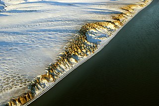
WThermokarst is a terrain-type, characterised by very irregular surfaces of marshy hollows and small hummocks formed as ice-rich permafrost thaws. The land surface type occurs in Arctic areas, and on a smaller scale in mountainous areas such as the Himalayas and the Swiss Alps.