 W
WAoyama Cemetery is a cemetery in Aoyama, Minato, Tokyo, Japan, managed by the Tokyo Metropolitan Government. The cemetery is also famous for its cherry blossoms, and at the season of hanami, which many people would visit.
 W
WGoryōkaku (五稜郭) is a star fort in the Japanese city of Hakodate on the island of Hokkaido. The fortress was completed in 1866. It was the main fortress of the short-lived Republic of Ezo.
 W
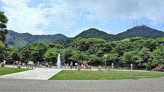
WHakodate Park is a large Western-style park in Hakodate, Hokkaidō, Japan, at the foot of Mount Hakodate. Opened in 1879, it is a registered as a "place of scenic beauty" in Japan's Law for the Protection of Cultural Properties. It contains the Hakodate City Museum, as well as a small zoo and children's theme park, and is a popular site for cherry blossom viewing.
 W
WHanami is the Japanese traditional custom of enjoying the transient beauty of flowers; flowers (hana) in this case almost always refer to those of the cherry (sakura) or, less frequently, plum (ume) trees. From the end of March to early May, cherry trees bloom all over Japan, and around the first of February on the island of Okinawa. The blossom forecast "cherry blossom front" is announced each year by the Japan Meteorological Agency, and is watched carefully by those planning hanami as the blossoms only last a week or two.
 W
WHinokinai River Embankment is a nationally designated Place of Scenic Beauty in the city of Semboku, Akita Prefecture, Japan.
 W
WHirosaki Castle is a hirayama-style Japanese castle constructed in 1611. It was the seat of the Tsugaru clan, a 47,000 koku tozama daimyō clan who ruled over Hirosaki Domain, Mutsu Province, in what is now central Hirosaki, Aomori Prefecture, Japan. It was also referred to as Takaoka Castle .
 W
WHita is a city located in Ōita Prefecture, Japan that was founded on December 11, 1940. It is an agricultural and industrial centre that primarily produces lumber, furniture, and pottery. Its attractions and scenic beauty also make it a popular tourist destination.
 W
WInokashira Park is a park which straddles Musashino and Mitaka in western Tokyo, Japan. Inokashira Pond (井の頭池) and the Kanda River water source , established during the Edo period, are the primary sources of the Kanda River.
 W
WMount Iwaki is a stratovolcano located in western Aomori Prefecture, Tohoku, Japan. It is also referred to as Tsugaru Fuji (津軽富士) and less frequently, Okufuji (奥富士) due to its similar shape to Mount Fuji. With a summit elevation of 1,625 meters (5,331 ft) and a prominence of 1,322 meters (4,337 ft) it is the highest mountain in Aomori Prefecture.
 W
WKakunodate was a town located in Senboku District, Akita Prefecture, Japan. In 2003, the town had an estimated population of 14,138 and a density of 90.26 persons per km². The total area was 156.63 km².
 W
WKamagatani (霞間ヶ渓) is a valley in the in the town of Ikeda, Gifu Prefecture, Japan noted for a scenic valley. It is a noted spot for viewing cherry blossoms in spring and was designated both a nationally designated Place of Scenic Beauty and Natural Monument,in 1928 It is located within the borders of the Ibi-Sekigahara-Yōrō Quasi-National Park.
 W
WMizumoto Park is a park in Katsushika ward, Tokyo, Japan. It is the biggest park within the 23 special wards of Tokyo. It is known for its diverse plants and wild birds, and as an attraction spot during the Hanami season. It is said to have a haunted phonebooth.
 W
WThe Philosopher's Walk is a pedestrian path that follows a cherry-tree-lined canal in Kyoto, Japan between Ginkaku-ji and Nanzen-ji. First opened in 1890 and extended again in 1912, the path follows the course of a shallow irrigation channel bringing water from the Lake Biwa Canal. The route is so-named because two 20th-century Japanese philosophers and Kyoto University professors Nishida Kitaro and Hajime Tanabe are thought to have used it for daily exercise. The path passes a number of temples and shrines such as Hōnen-in, Ōtoyo Shrine, and Eikan-dō Zenrin-ji. It takes about 30 minutes to complete the walk, although many people spend more time visiting the sights along the way. On the northern part of the walk, there are good views of the nearby Daimonji. The walk is a popular destination for tourists and locals, especially during hanami.
 W
WSakurayama (桜山) is a mountain in the city of Fujioka, Gunma Prefecture, Japan. It is 591 metres (1,939 ft) in height, and was named one of the "100 Sakura Spots in Japan" during Expo '90 by the International Flower and Green Expo Association. It is also a National Place of Scenic Beauty as determined by the Agency for Cultural Affairs in Japan.
 W
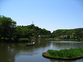
WSankei-en is a traditional Japanese-style garden in Naka Ward, Yokohama, Japan, which opened in 1906. Sankei-en was designed and built by Tomitaro Hara (原富太郎) (1868–1939), known by the pseudonym Sankei Hara, who was a silk trader. Almost all of its buildings are historically significant structures bought by Hara himself in locations all over the country, among them Tokyo, Kyoto, Kamakura, Gifu Prefecture, and Wakayama prefecture. Ten have been declared Important Cultural Property, and three more are Tangible Cultural Properties of Japan designated by the City of Yokohama. Badly damaged during World War II, the garden was donated in 1953 to the City of Yokohama, which entrusted it to the Sankeien Hoshōkai Foundation . Sankei-en was then restored almost to its pre-war condition.
 W
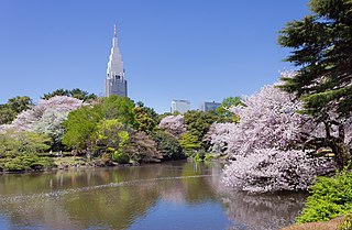
WShinjuku Gyo-en (新宿御苑) is a large park and garden in Shinjuku and Shibuya, Tokyo, Japan. It was originally a residence of the Naitō family in the Edo period. Afterwards, it became a garden under the management of the Imperial Household Agency of Japan. It is now a national park under the jurisdiction of the Ministry of the Environment.
 W
WTakaoka Castle was a flatland-style Japanese castle in what is now the city of Takaoka, Toyama Japan. It was originally constructed in 1609, and was only used for a few years before being dismantled. The site of its ruins are now a park. The castle is designated one of Japan's Top 100 Castles by the Japanese Castle Foundation.The ruins are protected as a National Historic Site.
 W
WTamagawadai Park is a public park located in Ota ward, Tokyo, Japan. It contains two ancient kofun burial mounds. It contains a number of cherry blossom trees and is also well known for its large number of hydrangea trees.
 W
WThe Tsutsujigaoka Park is a Japanese garden located in the city of Tatebayashi, Gunma Prefecture, Japan, which is a nationally designated Place of Scenic Beauty. It is also one of then "100 Japanese historical parks" designated in 2006 by the Ministry of Land, Infrastructure, Transport and Tourism to mark the 50th anniversary of the Urban Parks Law.
 W
WUeno Park is a spacious public park in the Ueno district of Taitō, Tokyo, Japan. The park was established in 1873 on lands formerly belonging to the temple of Kan'ei-ji. Amongst the country's first public parks, it was founded following the western example as part of the borrowing and assimilation of international practices that characterizes the early Meiji period. The home of a number of major museums, Ueno Park is also celebrated in spring for its cherry blossoms and hanami. In recent times the park and its attractions have drawn over ten million visitors a year, making it Japan's most popular city park.
 W
WYanaka Cemetery is a large cemetery located north of Ueno in Yanaka 7-chome, Taito, Tokyo, Japan. The Yanaka sector of Taito is one of the few Tokyo neighborhoods in which the old Shitamachi atmosphere can still be felt. The cemetery is famous for its beautiful cherry blossoms that in April completely cover its paths, and for that reason that its central street is often called Cherry-blossom Avenue.
 W
WMount Yoshino is a mountain located in the town of Yoshino in Yoshino District, Nara Prefecture, Japan that is a major religious and literary site. It is renowned for its cherry blossoms and attracts many visitors every spring, when the trees are in blossom. In 2004, Mount Yoshino was designated as part of a UNESCO World Heritage Site under the name Sacred Sites and Pilgrimage Routes in the Kii Mountain Range.
 W
WYoshino is a town located in Yoshino District, Nara Prefecture, Japan. As of September 1, 2007, the town had an estimated population of 6,337 and a density of 66.3 per square kilometre (172/sq mi). The total area was 95.65 km2 (36.93 sq mi).