 W
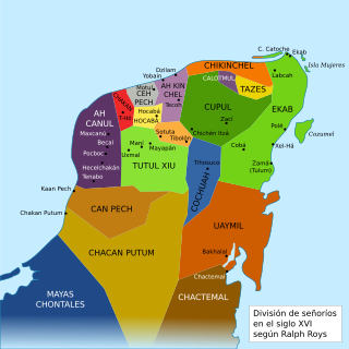
WAh Canul was the name of a Maya Kuchkabal of the northwest Yucatán Peninsula, before the arrival of the Spanish conquistadors in the sixteenth century.
WAh Kin Chel was the name of a Maya chiefdom or Kuchkabal of the northern Yucatán Peninsula, before the arrival of the Spanish conquistadors in the 16th century.
WCan Pech was the name of a Maya chiefdom of the southwestern Yucatán Peninsula, before the arrival of the Spanish conquistadors in the sixteenth century. Can Pech was south of Ah Canul and north of Chakán Putum, on the coast of the Gulf of Mexico. In 1517 the population of the capital city Campeche was approximately 36,000.
 W
WCeh Pech is the name of a post-classic Maya ruling family and a province, or kuchkabal of the northern Yucatán Peninsula.
WChakán oregano of this land; 2) macaw tail feathers.’) is the name of one of the Mayan jurisdictions (kuchkabalob) that existed on the Yucatan Peninsula at the arrival of the Spanish conquistadors in the sixteenth century. Unlike other jurisdictions, Chakán did not seem to have a centralized government or control of a dominant Halach Uinik, as in the case of the provinces Ceh Pech or Ah Kin Chel. This is inferred from the fact that upon the Spaniards' arrival, Francisco de Montejo was well received by some local leaders (batabob), but not others, such as Ah Kin Chuy, who organized resistance in the region's eastern towns to repel Spanish settlers.
WChakán Putum was the name of a Mayan chiefdom of the southwestern Yucatán Peninsula, before the arrival of the Spanish conquistadors in the sixteenth century. It was named after the capital city Chakan Putum. The city had approximately 8000 houses. It was a major port.
 W
WChetumal is a city on the east coast of the Yucatán Peninsula in Mexico. It is the capital of the state of Quintana Roo and the municipal seat of the Municipality of Othón P. Blanco. In 2020 it had a population of 169,028 people.
 W
WChetumal, or the Province of Chetumal was a Postclassic Mayan state in the Yucatan Peninsula.
WChikinchel was the name of a Mayan chiefdom of the northern coast of Yucatán, before the arrival of the Spanish conquistadors in the sixteenth century. Chauacá has also been used to refer to this province, but apparently it was the name of the main city.
WCochuah is the name of one of the sixteen Mayan provinces into which the central Yucatán Peninsula was divided at the time of the arrival of the Spanish conquistadors in the sixteenth century.
 W
WThe Cocom or Cocomes were a Maya family or dynasty who controlled the Yucatán Peninsula in the late Postclassic period. Their capital was at Mayapan. The dynasty was founded by Hunac Ceel, and was overthrown sometime between 1440 and 1441 by Ah Xupan of the Xiu lineage.
WCupul or Kupul, was the name of a Maya chiefdom at time of the Spanish conquest of Yucatán. Cupul was one of the most extensive and densely populated Maya provinces on the Yucatán Peninsula. It was formed in the mid-fifteenth century after the fall of Mayapan and reached its maximum power during the sixteenth century, at the time of their own Spanish conquest led by the adelantado Francisco de Montejo. According to the Encyclopedia Yucatán in time, the Mayan voice ku-pul, means that throws the bouncing, giving a connotation referring to the Mayan ballplayers that existed in the region.
WEkab or Ecab was the name of a Mayan chiefdom of the northeastern Yucatán Peninsula, before the arrival of the Spanish conquistadors in the sixteenth century. In the fifteenth century most of Yucatán was controlled by the League of Mayapan. By 1441 there was civil unrest. The provinces of the League rebelled and formed sixteen smaller states. These states were called Kuchkabals. Most Kuchkabals were ruled by a Halach Uinik, but Ekab wasn't. It was divided up into several Batabil. Each Batabil was ruled over by a leader called a Batab. In Ekab the Batabs were supposed to have equal power, but the Batabs on Cozumel had much more power than the others.
WHocabá-Homún, Hokabá-Homún or Hocabá was the name of a Maya Kuchkabal of the northwestern Yucatán Peninsula, before the arrival of the Spanish conquistadors in the sixteenth century.
 W
WThe Kejache were a Maya people in the southern Yucatán Peninsula at the time of Spanish contact in the 17th century. The Kejache territory was located in the Petén Basin in a region that takes in parts of both Guatemala and Mexico. Linguistic evidence indicates that the Kejache shared a common origin with the neighbouring Itzas to their southeast and the Kejache may have occupied the general region since the Classic period. The Kejache were initially contacted by conquistador Hernán Cortés in 1525; they were later in prolonged contact with the Spanish as the latter opened a route southwards towards Lake Petén Itzá.
WThe Kowoj [koʔwox] was a Maya group and polity, from the Late Postclassic period of Mesoamerican chronology. The Kowoj claimed to have migrated from Mayapan sometime after the city's collapse in 1441 AD. Indigenous documents also describe Kowoj in Mayapan and linguistic data indicate migrations between the Yucatán Peninsula and the Petén region.
 W
WThe Peten Itza kingdom was a kingdom centered on the island-city of Nojpetén on Lake Peten Itza.
 W
WPutún was the name of a Mayan chiefdom of the Yucatán Peninsula, before the arrival of the Spanish conquistadors in the sixteenth century. Its capital was Itzamkanac.
WSotuta is a small town and municipality of the Mexican state of Yucatán, and also was the name of a Mayan chiefdom of the northern central Yucatán Peninsula, before the arrival of the Spanish conquistadors in the sixteenth century.
WTases, also Tazes or Tasees, was the name of a Maya chiefdom of the northeastern Yucatán Peninsula, before the arrival of the Spanish conquistadors in the sixteenth century.
WTutul-Xiu, also Tutul Xiues or Mani, was the name of a Mayan chiefdom of the central Yucatán Peninsula with capital in Maní, before the arrival of the Spanish conquistadors in the sixteenth century.
WThe Yalain have been proposed as a Maya polity that existed during the Postclassic period in the Petén Basin of northern Guatemala, based in the central Petén lakes region. A small town called Yalain was described in 1696 by the Franciscan friar Andrés de Avendaño y Loyola. It was said to consist of a relatively small number of residences clustered within rich agricultural land. The town was located to the east of Lake Petén Itzá and was said to have been farmed by the inhabitants of Nojpetén, the capital city of the Itza kingdom. The political extent and archaeology of the Yalain is poorly understood.