 W
WA roadside park is a designated park on the wide side of a road for the traveling tourist usually maintained by a governmental entity, either local, state, or national. It is for recreational use such as a picnic spot or a trail head. A roadside park will generally be found in a rural setting, whereas a rest area will be found on an interstate highway in a suburban setting or between major destinations like cities. A rest area is specifically designed for the rest and relaxation of the motoring public. The roadside park with the use of picnic tables is the predecessor of the modern rest area / travel plaza.
 W
WThe Craigie Flour Mill Historical Marker is a wayside rest on Minnesota State Highway 78 in Otter Tail County, Minnesota. The site was designed by landscape architect Arthur R. Nichols and built by the National Youth Administration and the Minnesota Highway Department. The style is National Park Service Rustic architecture.
 W
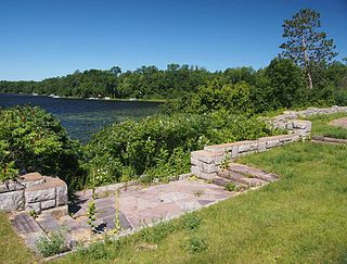
WThe Garrison Concourse is a roadside park on Mille Lacs Lake in Garrison, Minnesota, United States. The site consists of a wide parking area and scenic overlook projecting out into the lake, plus landscaped parkland along the shore in both directions. It was built from 1936 to 1939 as the centerpiece of the Mille Lacs Highway Development Plan, a major New Deal project to create a scenic parkway along the lakeshore. The park was listed on the National Register of Historic Places in 2013 for having state-level significance in the themes of landscape architecture and politics/government. It was nominated for being the premiere structure of the most extensive roadside development project undertaken by the Minnesota Highway Department and the Civilian Conservation Corps, and for its blend of formalism and National Park Service rustic design.
 W
WJohn Stretch Park is a small roadside park on the south side of Lake Okeechobee. The park provides picnic areas, restrooms, a large grassy field, an outdoor basketball court, and a boat ramp. Admission is not charged. The entire north edge of the park is dominated by the twenty-foot dike surrounding the lake. Set into this dike at one end of the park are flood control machinery and a lock for moving boats into and out of the lake. The Lake Okeechobee Scenic Trail can be accessed from the park.
 W
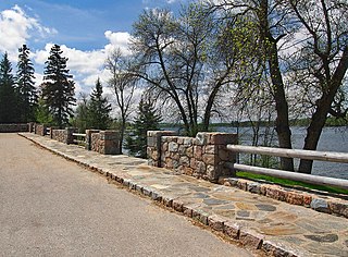
WThe Kenney Lake Overlook is a historic roadside park in Garrison Township, Minnesota, United States. Adjacent to the southbound lane of Minnesota State Highway 18 (MN 18), the two-acre (0.8 ha) site provides a parking area and an overlook of a small lake. The wayside was built in 1939 as part of a major New Deal project to create a scenic parkway along the shore of nearby Mille Lacs Lake. The Mille Lacs Highway Development Plan was the largest highway improvement project in the state constructed by the Civilian Conservation Corps (CCC). The Kenney Lake Overlook was listed on the National Register of Historic Places in 2015 for having state-level significance in the themes of landscape architecture and politics/government. It was nominated for being a key component of a major highway improvement project, for representing the work of the Veterans Division of the CCC and the earliest scenic improvements of the Minnesota Highway Department (MHD), and for its fine National Park Service rustic design.
 W
WThe Morgan Morgan Monument, also known as Morgan Park, is a 1.05-acre (0.4 ha) roadside park in the unincorporated town of Bunker Hill in Berkeley County, West Virginia. It is located along Winchester Avenue and Mill Creek. The park features a granite monument that was erected in 1924 to memorialize Morgan Morgan (1688–1766), an American pioneer of Welsh descent, who was among the earliest European persons to settle permanently within the present-day boundaries of West Virginia.
 W
WThe Orr Roadside Parking Area is a roadside park on U.S. Route 53 in Orr, Minnesota, United States. It was built from 1935 to 1938 as a New Deal project to provide motorists with recreational access to Pelican Lake. It was designed by landscape architect Arthur R. Nichols and constructed by the Civilian Conservation Corps in collaboration with the Minnesota Department of Highways. The overlook was listed on the National Register of Historic Places in 2002 for its state-level significance in the themes of landscape architecture and politics/government. It was nominated for exemplifying the early highway waysides built in Minnesota with federal work relief aid, and for exemplifying National Park Service rustic style and the work of Nichols.
 W
WPine-Hickory Lakes Roadside Parking Area is a wayside rest located along U.S. Highway 169 in Farm Island Township, Aitkin County, Minnesota. It straddles both sides of the highway just north of where it passes between Little Pine Lake on the west and Hickory Lake on the east. It is one of the largest wayside rests developed by the Minnesota Highway Department during the New Deal, at 35 acres (14 ha). Arthur R. Nichols, collaborating with engineer Harold E. Olson, designed the rest area in the National Park Service rustic style. The wayside rest was listed on the National Register of Historic Places in May 2016.
 W
WPocahontas Mounds is an archaeological site from the Plaquemine Mississippian culture in Hinds County, Mississippi, dating from 800 to 1300 CE. Two mounds from the site were added to the NRHP on two separate occasions, Pocahontas Mound A on November 25, 1969 as NRIS number 69000365 and Pocahontas Mound B on April 11, 1972 as NRIS number 72000694. The mounds are listed on the Mississippi Mound Trail.
 W
WPreston Overlook is a historic scenic overlook in Preston, Minnesota, United States, North America.
 W
WThe Pyeatte Mill Site is a roadside park encompassing the remains of a historic early 20th-century mill facility on Arkansas Highway 45 in Canehill, Arkansas. The principal surviving features are a large stone foundation wall and a massive steel wheel 36 feet (11 m) in diameter. These are all that remain of what was once Canehill's leading 19th-century industrial facility, which had its origins in the 1830s. It operated at this site from 1902 into the 1920s.
 W
WThe Reads Landing Overlook is a scenic overlook on U.S. Route 61 in Pepin Township, Minnesota, United States. It was built from 1939 to 1940 as a New Deal project to provide motorists with a scenic view of Lake Pepin. It was designed by landscape architect Arthur R. Nichols and constructed by the National Youth Administration. The overlook was listed on the National Register of Historic Places in 2004 for its state-level significance in the themes of landscape architecture and politics/government. It was nominated for exemplifying the early highway waysides built in Minnesota with federal work relief aid, and for exemplifying as well National Park Service rustic style and the work of Nichols.
 W
WThe St. Croix Boom Site is a historic and scenic wayside on the St. Croix River in Stillwater Township, Minnesota, United States. It commemorates the location of a critical log boom where, from 1856 to 1914, timber from upriver was sorted and stored before being dispatched to sawmills downstream. The site was developed as a roadside park along Minnesota State Highway 95 in the 1930s. In 1966 it was designated a National Historic Landmark for its national significance in the theme of industry. It was nominated for being the earliest, most important, and longest serving of the log storage and handling operations that supported Minnesota's major logging industry. Virtually no traces remain of the site's original buildings and structures.
 W
WThe Stillwater Overlook is a scenic overlook in Oak Park Heights, Minnesota, United States, just south of the city limits of Stillwater, near the junction of Minnesota State Highway 36 and Minnesota State Highway 95. The overlook was listed on the National Register of Historic Places in 2007 for having state-level significance in politics/government and landscape architecture. It was nominated as a leading example of the early wayside rests developed by the Minnesota Department of Highways Roadside Development Division, as well as for its sophisticated and well-preserved National Park Service rustic architecture, and for being an important work of Minnesota landscape architect Arthur R. Nichols.
 W
WVirginia Furnace, also known as Muddy Creek Furnace and Josephine Furnace, is a historic water powered blast furnace and national historic district located near Albright, Preston County, West Virginia. The district encompasses three contributing structures and one contributing site. The furnace was built in 1854, and was a "charcoal" iron furnace used to smelt iron. It is constructed of cut sandstone, and forms a truncated pyramid measuring approximately 34 feet square in plan and rising about 30 feet. The district includes the nearby wheel pit, blast machinery, and salamander. The furnace remained in operation until the 1890s, and was the last "charcoal" iron furnace to cease operating in northern West Virginia. In 1933, the Virginia Furnace was acquired by the Kingwood Chapter of the Daughters of the American Revolution who created a roadside park at the furnace site.