 W
WBicuari National Park is a national park in Angola. It is located in the south-west region of the country on the Huila Plateau, about 120 km SE of Lubango. The park is an area of sandy hills and shrub thicket character. The climate is tropical semi-arid. Bicuar was established as a hunting reserve in 1938, and reformed as a national park in 1964. Historically known for its large mammals, such as the black buffalo, the park suffered heavily in the Angolan Civil War (1975-2002). During this time the animals were mostly or entirely exterminated, but the Angolan Government is now undertaking efforts to rebuild the infrastructure and resettle the animals.
WCameia National Park is a national park in the Moxico province of Angola, located at about 1100 m above sea level. Covering a surface of 14.450 km2. It shares its name with the nearby municipality of Cameia. The Cameia–Luacano road forms the northern boundary of the park with the Chifumage River forming the southern portion of the eastern boundary and the Lumege and Luena rivers the south-western boundary. Much of the park consists of seasonally inundated plains that form part of the Zambezi river basin, with the northern half of the park draining into the Chifumage river. There are also extensive miombo woodlands, similar to those in the Zambezi basin of western Zambia. The park is a sample of nature not occurring elsewhere in Angola. Two lakes, Lago Cameia and Lago Dilolo lie outside the park boundaries and both have extensive reedbeds and grassy swamps that are rich in aquatic birds.
WCangandala National Park is a national park in Malanje Province, Angola. It is situated between the Cuije river and 2 unnamed territories of the Cuanza, with the towns of Culamagia and Techongolola on the edges of the park. It is the smallest national park in Angola.
 W
WIona National Park is the largest national park in Angola. It is situated in the Southwestern corner of the country, in Namibe Province. It is roughly bound by the Atlantic Ocean to the West, an escarpment to the East that marks the beginning of the interior plateau, the Curoca River to the North, and the Cunene River to the South. It is about 200 kilometres (120 mi) south of the city of Namibe and covers 5,850 square miles (15,200 km2) sq. miles.
 W
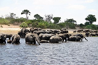
WKavango–Zambezi Transfrontier Conservation Area (KAZA) is situated in a region of Southern Africa where the international borders of five countries converge. It includes a major part of the Upper Zambezi River and Okavango basins and Delta, the Caprivi Strip of Namibia, the southeastern part of Angola, southwestern Zambia, the northern wildlands of Botswana and western Zimbabwe. The centre of this area is at the confluence of the Zambezi Chobe Rivers where the borders of Botswana, Namibia, Zambia and Zimbabwe meet. It incorporates Chobe National Park, Hwange National Park, and the Victoria Falls.
 W
WQuiçama National Park, also known as Kissama National Park, is a national park in northwestern Angola.
WMavinga is a National Park in Kuando Kubango Province in south-eastern Angola. It covers an area of 46,076 square kilometres (17,790 sq mi). The Park was proclaimed in 2011 along with the neighbouring Luengue-Luiana National Park, which measures 22,610 square kilometres (8,730 sq mi). The two parks are contiguous and managed as a single unit. The parks were created to conserve the areas’ high ecological and biological value. Mavinga forms the western border of Africa's largest conservation area, the Kavango-Zambezi Trans-Frontier Conservation Area.
WMupa National Park is a national park in Angola's Cunene province. It was proclaimed a national park on 26 December 1964 while Angola was a Portuguese territory.
WQuiçama National Park, also known as Kissama National Park, is a national park in northwestern Angola.