 W
WBettenauer Weiher is a reservoir between Jonschwil and Oberuzwil in the Canton of St. Gallen, Switzerland. The reservoir formed in the 15th century when a dam was built for a fish pond. Today, fishing in the lake is only allowed for retired persons of the local industrial enterprise Bühler AG, to which it belongs.
 W
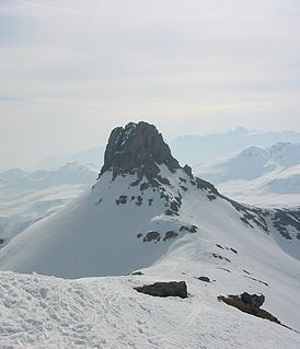
WThe Brisi is a mountain of the Churfirsten group, located in the Appenzell Alps. It overlooks Lake Walenstadt in the canton of St. Gallen. The summit is easily accessible by trail but via the north side in Toggenburg only.
 W
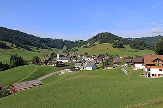
WBrunnadern is a village in the municipality of Neckertal in the Wahlkreis (constituency) of Toggenburg in the canton of St. Gallen in Switzerland.
 W
WThe Bützistock is a mountain of the Glarus Alps. It lies on the border between the cantons of Glarus and St. Gallen in Eastern Switzerland. The top is 2,496 m (8,189 ft) above sea level or 513 meters above the surrounding terrain. The width at the base is 18 km.
 W
WThe Calanda is a mountain in the Glarus Alps with two main peaks Haldensteiner Calanda (highest) and Felsberger Calanda, both located on the border between the cantons of St. Gallen and Graubünden in eastern Switzerland. It looms over Chur, the capital city of Graubünden.
 W
WChapfensee is a reservoir at Mels, Canton of St. Gallen, Switzerland. The area around the reservoir is a nature preserve.
 W
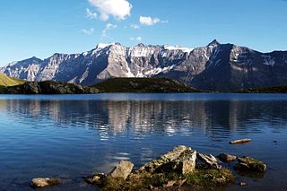
WThe Chüemettler is a mountain of the Appenzell Alps, overlooking the Walensee in the canton of St. Gallen. It lies south of the Speer and southeast of the Federispitz mountains. Chüe literally means cows in Swiss-German language, Mettler is a family name respectively a term used as name of several local areas.
 W
WThe Fahnenstock is a mountain of the Glarus Alps, located south of Weisstannen in the canton of St. Gallen.
 W
WThe Federispitz is a mountain of the Appenzell Alps, overlooking the Walensee in the canton of St. Gallen. It lies south of the Speer.
 W
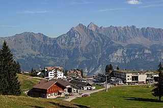
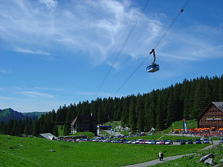
WFlumserberg is a resort area in the Swiss Alps, located in the canton of St. Gallen. It is composed of several villages at elevations between 1,160 and 1,344 metres above sea level. The resort sits on a terrace overlooking the Walensee, above Flums in the Sarganserland region. Flumserberg mainly belongs to the municipality of Flums, with a small part belonging to the municipality of Quarten.
 W
WThe Foo Pass is a mountain pass of the Glarus Alps, located on the border between the Swiss cantons of St. Gallen and Glarus, at an elevation of 2,223 m (7,293 ft). It crosses the col between the peaks of Foostock and Piz Sardona.
 W
WThe Foostock, also known as the Ruchen, is a mountain of the Glarus Alps, located on the border between the Swiss cantons of Glarus and St. Gallen. It lies north of Piz Sardona, on the range that separates the Sernftal from the Weisstannental.
 W
WThe Frümsel is one of the peaks of the Churfirsten group, located in the Appenzell Alps. It lies between the valley of Toggenburg and Lake Walenstadt in the canton of St. Gallen. The summit is easily accessible by a trail on the northern side.
WThe Fulfirst is a mountain of the Appenzell Alps, located north of Flums in the canton of St. Gallen. It lies in the Alvier group, between the Walensee and the Rhine Valley.
 W
WThe Gamsberg is a mountain in the Appenzell Alps, overlooking the region of Walenstadt in the canton of St. Gallen. Located in the Alvier group it is the culminating point of the range lying between Lake Walenstadt and Toggenburg.
 W
WThe Gauschla is a mountain of the Appenzell Alps, located north of Sargans in the canton of St. Gallen, Switzerland. It lies near the southern end of the range between the Walensee and the Rhine Valley, and one kilometre south-east of the Alvier. Just 600 metres south-east of the Gonschla, and clearly seen from the Rhine Valley, is the Girrenspitz.
 W
WGigerwaldsee is a reservoir in the municipality of Pfäfers, in the Canton of St. Gallen, Switzerland. The reservoir has a volume of 35.6 million m³ and a surface area of 71 ha.
 W
WThe Gonzen is a mountain of the Appenzell Alps, overlooking the Rhine Valley at Sargans, in the canton of St. Gallen. It lies at the southeastern end of the Alvier group.
 W
WGübsensee is a reservoir near the city of St. Gallen, Switzerland. Its dams were built between 1898 and 1900, the first hydroelectric reservoir in Switzerland. Kraftwerk Kubel has generated electrical power there since 1900.
WThe Hangsackgrat is a mountain of the Glarus Alps, located south of Weisstannen in the canton of St. Gallen. It lies on the range east of Piz Sardona, that separates the Weisstannental from the Calfeisental.
WThe Hochfinsler is a mountain of the Glarus Alps, located south of Flums in the canton of St. Gallen. It lies on the range north of the Wissgandstöckli, that separates the Schilstal from the Weisstannental.
WThe Hochmättli is a mountain of the Glarus Alps, located on the border between the Swiss cantons of Glarus and St. Gallen. It lies in the Murgtal, near the Murgsee, south of the Walensee.
 W
WHulftegg Pass is a mountain pass between the cantons of Zürich and St. Gallen in Switzerland.
 W
WThe Leistchamm is a mountain of the Appenzell Alps, located east of Amden in the canton of St. Gallen. It lies at the western end of the range overlooking the Walensee, named Churfirsten.
 W
WThe Magerrain is a mountain of the Glarus Alps, located on the border between the cantons of Glarus and St. Gallen in Eastern Switzerland. Reaching an elevation of 2,524 metres above sea level, the Magerrain is the highest summit of the range north of the Walabützer Furggle and the Risitenpass.
 W
WThe Mattstock is a mountain of the Appenzell Alps, overlooking the Walensee in the canton of St. Gallen. It lies south of the Speer, on the range between the Toggenburg and the Linth valley.
 W
WMogelsberg is a municipality in the Wahlkreis (constituency) of Toggenburg in the canton of St. Gallen in Switzerland.
 W
WMühlrüti is a small town in the Canton of St. Gallen in Switzerland. It is part of the municipality of Mosnang in Toggenburg, in hilly northeastern Switzerland. The population of about 400 people works mainly in the dairy farming industry.
WOberer Murgsee is a lake in the Murg valley (Murgtal), in the canton of St. Gallen, Switzerland. It is the highest of the three Murgseen.
 W
WMurgseen are a group of lakes in Murgtal in the Canton of St. Gallen, Switzerland. The three lakes are drained by the Murgbach river, which empties into Lake Walen at Murg in the municipality of Quarten.
 W
WOberricken Pass is a mountain pass in the canton of St. Gallen in Switzerland. It connects the lower Ricken Pass with the villages Walde and Rüeterswil, in the municipality St. Gallenkappel.
 W
WThe Pizol is a mountain in the Glarus Alps of northeastern Switzerland, overlooking Wangs in the canton of St. Gallen. At 2,844 metres above sea level, it is the highest summit of the chain separating the valleys of the Seez and the Tamina rivers, and the highest mountain lying entirely within the canton of St. Gallen.
 W
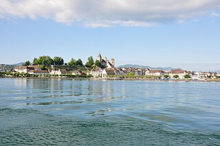
WRapperswil Peninsula is a peninsula located in Rapperswil on the northeastern Lake Zürich shore in Switzerland. On the northwest, Kempratnerbucht is situated, on the south Seedamm respectively Holzbrücke Rapperswil-Hurden is linking both shores of the lake respectively Obersee.
 W
WThe Ricken Pass is a mountain pass in the canton of St. Gallen in eastern Switzerland. At a maximum altitude of 790 metres (2,590 ft), it connects the Linth valley and the Toggenburg.
 W
WThe Ringelspitz is a mountain of the Glarus Alps, located on the border between the Swiss cantons of St. Gallen and Graubünden. Reaching a height of 3,248 metres above sea level, it is the highest summit in the canton of St. Gallen. It is split between three municipalities: Pfäfers, Trin and Tamins (Graubünden).
WThe Riseten Pass is a mountain pass of the Glarus Alps, located on the border between the Swiss cantons of St. Gallen and Glarus, at an elevation of 2,189 m (7,182 ft). It crosses the col between the peaks of the Wissgandstöckli and Foostock.
 W
WRuppen Pass is a high mountain pass between the cantons of St. Gallen and Appenzell Ausserrhoden in Switzerland.
 W
WThe Sazmartinshorn is a mountain of the Glarus Alps, overlooking St. Martin and the lake of Gigerwald in the canton of St. Gallen. It lies on the range east of Piz Sardona, that separates the Weisstannental from the Calfeisental. After the Pizol, the Sazmartinshorn is the second highest mountain lying entirely within the canton of St. Gallen.
 W
WThe Schibenstoll is one of the peaks of the Churfirsten group, located in the Appenzell Alps. It lies between the valley of Toggenburg and Lake Walenstadt in the canton of St. Gallen. The summit is easily accessible by a trail on the northern side.
 W
WSchwägalp Pass is a high mountain pass in the Alps between the cantons of St. Gallen and Appenzell Ausserrhoden in Switzerland.
 W
WSchwarzsee is a mountain lake at an elevation of 2368 m on the Pizol mountain of the Glarus Alps.
 W
WSchwendisee is a small lake above Wildhaus on the slopes of the Churfirsten, in Toggenburg, Canton of St. Gallen, Switzerland. Besides the main lake, there is a smaller lake nearby.
 W
WThe Spitzmeilen is a mountain of the Glarus Alps, lying on the border between the Swiss cantons of Glarus and St. Gallen. It lies between the valleys of Schilstal and Sernftal.
 W
WSt. Anton Pass is a high mountain pass in the Alps between the cantons of Appenzell Innerrhoden and St. Gallen in Switzerland.
 W
WSt. Peterzell is a municipality in the Wahlkreis (constituency) of Toggenburg in the canton of St. Gallen in Switzerland.
 W
WStausee Mapragg is located at Pfäfers in the Canton of St. Gallen, Switzerland. Its surface area is 26 ha. The reservoir and Gigerwaldsee are operated by Kraftwerke Sarganserwald for pumped-storage hydroelectricity.
 W
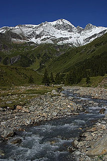
WThe Tamina is a river in Switzerland that originates on the flanks of Piz Sardona in the Glarus Alps and flows eastwards and northwards to finally merge with the Alpine Rhine after about 18 km total length.
 W
WThe Tristelhorn is a mountain of the Glarus Alps, located on the border between the Swiss cantons of St. Gallen and Graubünden. Reaching a height of 3,114 metres above sea level, it is one of the highest summits in the canton of St. Gallen.
 W
WUnterwasser is a village in the Toggenburg region of the canton of St. Gallen, Switzerland, situated at the confluence of the two streams forming the upper Thur. Formerly part of Wildhaus municipality, it has since 2010 been part of Wildhaus-Alt St. Johann by merger of Wildhaus and Alt St. Johann. It is a relatively small ski resort, and many of its trails are shared with nearby Wildhaus.
 W
WVoralpsee is a lake above Grabs in the Canton of St. Gallen, Switzerland.
 W
WWasserfluh Pass is a mountain pass in the canton of St. Gallen in Switzerland.
 W
WWerdenbergersee is a small lake in Buchs, below the town of Werdenberg, in the municipality of Grabs, Canton of St. Gallen, Switzerland.
 W
WWildhaus Pass is a high mountain pass in the Alps in the canton of St. Gallen in Eastern Switzerland. The main road culminates at 1,090 metres, while the pass itself lies at an elevation of 1,027 metres above sea level.
 W
WWildhaus-Alt St. Johann is a municipality in the Wahlkreis (constituency) of Toggenburg in the canton of St. Gallen in Switzerland. It was formed on 1 January 2010 through the merger of Alt St. Johann and Wildhaus.
WThe Wissgandstöckli is a mountain of the Glarus Alps, located on the border between the Swiss cantons of Glarus and St. Gallen. It lies approximately halfway between Matt and Weisstannen.
WThe Zanaihorn is a mountain of the Glarus Alps, located north of Vättis in the canton of St. Gallen. It lies on the range east of the Pizol, between the valleys of the Zanaibach and the Tersolbach.
 W
WThe Zuestoll is one of the peaks of the Churfirsten group, located in the Appenzell Alps. It lies between the valley of Toggenburg and Lake Walenstadt in the canton of St. Gallen. The summit is easily accessible by a trail on the northern side.