 W
WThe Ākitio River is in the North Island of New Zealand. It flows generally southeast for 35 kilometres (22 mi), entering the Pacific Ocean at Ākitio to the south of Cape Turnagain on the east coast.
 W
WAlfredton is a farming community in the southern North Island of New Zealand. It is located to the southeast of Eketahuna. Alfredton has a school, church, a 9-hole golf course, community domain and a community hall.
 W
WLake Alice is a small lake approximately 7 kilometres (4 mi) south west of Marton in the Manawatū-Whanganui region of the North Island. The nearby Lake Alice Hospital that closed in 1999 is named after the lake.
 W
WĀtene is a former village located 35 kilometres (22 mi) up the Whanganui River from Whanganui. Originally called Warepakoko, then Kakata, it was renamed by the missionary Richard Taylor in the 19th century as a Māori transliteration of Athens. It was the home of the hapū Ngāti Hineoneone of the iwi Te Āti Haunui-a-Pāpārangi. A small meeting house called Te Rangi-i-heke-iho, restored by carver Bill Ranginui, is all that remains.
 W
WBruce Park Scenic Reserve is located near Hunterville in the Rangitikei District of the North Island of New Zealand.
 W
WCape Turnagain is a prominent headland on the east coast of New Zealand's North Island, part way between Hawke Bay and Cook Strait, between the mouths of the Porangahau and Ākitio Rivers.
 W
WErua is a small town on the North Island Central Plateau in New Zealand. The town is located on New Zealand State Highway 4 immediately to the south of the town of National Park. The town is administered by the Ruapehu District Council and falls within the National Park Ward.
 W
WHauhungatahi is an eroded volcano at the southern end of the Taupo Volcanic Zone in New Zealand, located about 11 kilometres (7 mi) WNW of Mount Ruapehu. Although relatively little-known, at 1,521 metres (4,990 ft) Hauhungatahi is one of the highest volcanoes in New Zealand, exceeded in elevation by only Ruapehu, Taranaki/Egmont, and the Tongariro massif. The volcano is constructed atop an upfaulted block of Mesozoic marine sediments. The age of the erupted andesite lava is about 900,000 years, making Hauhungatahi more than three times as old as the neighboring Ruapehu.
 W
WThe Hautapu River is a river in the Manawatū-Whanganui region of New Zealand. It originates from Ngamatea Swamp in the New Zealand Army's Waiouru Training area. From here it flows south, through private farmland, and in some places following State Highway 1, for several kilometres before entering the Rangitikei River south of Taihape.
WHoropito is a locality in the North Island of New Zealand. It lies on State Highway 4 between the village of National Park and the town of Raetihi.
 W
WLake Horowhenua is located in the Horowhenua District, an area of the southern Manawatū-Whanganui region in New Zealand's North Island. It covers an area of 3.9 square kilometres (1.5 sq mi).
 W
WHunterville is a small community on State Highway 1, in the Rangitikei district of the North Island of New Zealand. It is located halfway between Taupo and Wellington and has a population of 429, a decrease of 15 people from 2006.
 W
WKai Iwi is a rural community west of Whanganui in New Zealand's North Island. It lies close to SH 3, approximately halfway between Whanganui and Waitotara.
 W
WKaiwhaiki is a settlement 18 kilometres (11 mi) upriver from Whanganui, New Zealand.
WKakatahi is a New Zealand town located 50 kilometres (31 mi) from Wanganui, on State Highway 4 to Raetihi. The once bustling roadworkers' camp is now closed and the introduction of private contractors has seen the community dwindle, with local families contributing to a school roll of only about a dozen in 2007.
WKimbolton is a rural village north of Feilding in the Manawatu District of the North Island of New Zealand. Kimbolton is named after Kimbolton, Cambridgeshire, a village in England which is the site of Kimbolton Castle, once the home of the Duke of Manchester. It was originally called Birmingham, after Birmingham, England.
 W
WKoriniti is a settlement 47 kilometres (29 mi) upriver from Whanganui, New Zealand, home to the Ngāti Pāmoana hapū of the iwi Te Āti Haunui-a-Pāpārangi.
WLake Moawhango is a small artificial lake located with the New Zealand Army's Waiouru Military Camp. It is fed by the Mangaio Stream, boosted by tributaries diverted from the slopes of Mt Ruapehu, and by the Moawhango River. Water is taken from the lake for the Tongariro Power Scheme, feeding the Tongariro River via the Moawhango Tunnel, although some water is released to continue down the Moawhango River nearby the settlement of Moawhango. The lake is dammed at the southern end.
 W
WLake Virginia is a lake in the city of Whanganui in the North Island of New Zealand.
 W
WThe Mangahao River is located in the North Island of New Zealand. The headwaters are in the Tararua Ranges. The river flows northeast feeds into the Manawatu River south of Woodville.
 W
WThe Mangawhero River is in the North Island of New Zealand.
WMarco is a settlement in the Stratford District and the Manawatū-Whanganui region, in the western North Island of New Zealand. It is located to the northeast of Whangamōmona on State Highway 43. The Whangamōmona River flows through the area. The Stratford - Okahukura railway line passes to the northwest of the settlement.
 W
WMoutoa Island is an island of shingle approximately 500 metres (1,600 ft) long, 80 kilometres (50 mi) up the Whanganui River, New Zealand between the towns of Rānana and Hiruharama.
 W
WŌhau is a village and semi-rural community in the Horowhenua District and Manawatū-Whanganui region of New Zealand's North Island. It is located just south of Levin on State Highway 1.
 W
WŌhura is a small town in the west of the North Island of New Zealand. It is located to the west of Taumarunui in the area known as the King Country, in inland Manawatū-Whanganui. It lies on the banks of the Mangaroa Stream, a tributary of the Ōhura River which is a tributary of the Whanganui River.
 W
WOngarue is a rural community in the Ruapehu District and Manawatū-Whanganui region of New Zealand's North Island. It is located south of Te Kuiti and Waimiha, and north of Taumarunui. It is in meshblock 1041902, which had a population of 54 in 2013.
 W
WOpiki is a small rural settlement in the Horowhenua district of New Zealand's North Island. It is located on the floodplain of the Manawatu River, 15 km (9 mi) southwest of Palmerston North.
 W
WOroua County was one of the counties of New Zealand in the North Island. Centred on the town of Feilding, it had an extent of just under 500 square kilometres.
 W
WThe Oroua River is a river of the southwestern North Island of New Zealand.
 W
WPipiriki is a settlement in New Zealand, on the east bank of the Whanganui River, due west of the town of Raetihi and 79 kilometres (49 mi) upriver from Whanganui; it was originally on the opposite bank. It is the home of Ngāti Kura, a hapū of the Ngāti Ruanui iwi. It is also the location of the Paraweka Marae of the hapū Ngāti Kurawhatia of the iwi Te Āti Haunui-a-Pāpārangi.
 W
WPiriaka is a small rural settlement beside the Whanganui River, about 10 kilometres (6.2 mi) southeast of Taumarunui on State Highway 4 (SH4), in New Zealand's King Country. Its name is Māori, from piri and aka.
 W
WPohangina is a small rural community in the Manawatū-Whanganui region of New Zealand, just north of Ashhurst.
 W
WThe Pohangina River is a river of the southwestern North Island of New Zealand. A tributary of the Manawatu River, it flows generally southward from its source in the Ruahine Range, through Pohangina, joining the Manawatu River about 15 kilometres (9 mi) northeast of Palmerston North at Ashhurst.
 W
WPokaka is a locality 12 km (7.5 mi) south of National Park Village in Ruapehu District, Manawatū-Whanganui region, the Central North Island of New Zealand.
 W
WRanana is a settlement 60 kilometres (37 mi) up the Whanganui River from Whanganui, New Zealand.
 W
WThe Rangitīkei River is one of New Zealand's longest rivers, 185 kilometres (115 mi) long.
 W
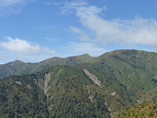
WThe Ruahine Range is the largest of several mountain ranges in the North Island of New Zealand that form a ridge running parallel with the east coast of the island between East Cape and Wellington. The ridge is at its most pronounced from the central North Island down to Wellington, where it comprises the Ruahine, Tararua and Remutaka Ranges.
 W
WThe Tama Lakes are two crater lakes in New Zealand's Tongariro National Park. They fill two of a series of explosion craters on the Tama Saddle between Mount Ruapehu and Mount Ngaruahoe.
 W
WThe Tāngarākau River is a river of the Taranaki and Manawatū-Whanganui regions of New Zealand's North Island. It flows south from its sources to the northeast of Whangamōmona in the King Country to reach the Whanganui River. State Highway 43, known as the Forgotten World Highway, travels through the Tāngarākau Gorge.
 W
WTerrace End is a suburb of Palmerston North, New Zealand.
 W
WThe Tokomaru River is a river of the Manawatū-Whanganui Region of the North Island of New Zealand. It rises to the southeast of Shannon and initially flows northeast down a long valley in the Tararua Range before turning northwest to reach the edge of the Manawatū Plain near the town of Tokomaru. From here it turns southwest, reaching the Manawatū River 3 kilometres (2 mi) north of Shannon.
 W
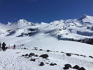
WTukino skifield is located on the eastern face of Mount Ruapehu, in the central area of the North Island, New Zealand.
 W
WThe Tukituki River is found in the eastern North Island of New Zealand. It flows from the Ruahine Ranges to the Pacific Ocean at the southern end of Hawke's Bay.
WTurakina is an old Māori settlement situated southeast of Whanganui city on the North Island of New Zealand. Turakina village derives its name from the Turakina River, which cut its passage to the sea from a source south of Waiouru.
 W
WThe Wahianoa River is a river of the Manawatū-Whanganui region of New Zealand's North Island. One of the headwaters of the Whangaehu River, it flows southeast from the southern slopes of Mount Ruapehu, gradually veering southwest before meeting the Whangaehu 3 kilometres (2 mi) northwest of Waiouru.
WWest End is a suburb of the New Zealand city of Palmerston North.
 W
WThe Whakapapa River in New Zealand trickles off the Whakapapa skifield of Mount Ruapehu, down the western slopes of the mountain, passing near Ōwhango before finally merging with the Whanganui River just east of Kakahi at 38°55.92′S 175°24.5′E.
 W
WThe Whangaehu River is a large river in central North Island of New Zealand. Its headwaters are the crater lake of Mount Ruapehu on the central plateau, and it flows into the Tasman Sea eight kilometres southeast of Whanganui. Water is diverted from the headwaters for the Tongariro Power Scheme.
WWhanganui Airport is the airport that serves Whanganui, New Zealand. It is located to the south of Whanganui River, approximately 4 km from the centre of Whanganui. The airport was opened in 1954, and services to the airport began in November that year. In September 2013, Air New Zealand announced that it would withdraw services from Whanganui to Wellington and Taupo in December 2013. Sounds Air briefly took over the Wellington route, however this was later terminated on 15 May 2015. The airport has a single terminal with just two gates. Air Chathams now operates to Wanganui from Auckland.
 W
WThe Whanganui National Park is a national park located in the North Island of New Zealand. Established in 1986, it covers an area of 742 km² bordering the Whanganui River. It incorporates areas of Crown land, former state forest and a number of former reserves. The river itself is not part of the park.
 W
WWharite Peak is a mountain at the southern end of the Ruahine Range, 9 km (5.6 mi) north of Woodville in the Manawatū-Whanganui region of New Zealand. The mountain is home to the main television transmitter for the city of Palmerston North and the wider Manawatu region.
WWimbledon is a farming locality in the Tararua District, New Zealand. It is located on the former SH 52 between Waipukurau and Masterton. It is 21 kilometres (13 mi) from Weber, 9 kilometres (5.6 mi) from Herbertville on the coast, and 11 kilometres (6.8 mi) inland from Cape Turnagain. The Waikopiro Stream runs into the Wainui River at Wimbledon.