 W
WAksai Chin is a region administered by China as part of its Xinjiang and Tibet autonomous regions, and constituting the eastern portion of the larger Kashmir region which has been the subject of a dispute between India and China since the late 1950s.
 W
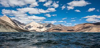
WAksai Chin Lake or Aksayqin Lake, is an endorheic lake in the disputed Aksai Chin region of Kashmir. The plateau is administered by China but also claimed by India. Its Tibetan/Ladakhi name is Amtogor Lake which means "encounter with a round object".
 W
WThis is a list of basins, camping grounds, lakes, mountains, mountain passes, outposts, plains, rivers, ruins, settlements, streams, valleys, villages, and other geographical features located in the sparsely populated Aksai Chin region administered by China and claimed by India as part of Ladakh. The alternate language names of locations in the Aksai Chin area are included for reference.
 W
WThe Ardagh–Johnson Line is a proposed boundary of Kashmir abutting Chinese Turkestan and Tibet. It was formally proposed to the British Indian government by Major General John Ardagh, chief of military intelligence in London, in 1897, based on the surveys conducted by William Johnson in 1865.
 W
WThe Bum La Pass is a border pass between Tibet's Cona County and India's Tawang district in Arunachal Pradesh. It is 37 km away from the town of Tawang and 43 km from the town of Cona. The pass currently serves as a trading point between Tawang and Tibet. It is also an agreed Border Personnel Meeting point for the security forces of China and India.
 W
WChepzi or Chabji is a village and military post in the Zanda County of Tibet in China, close to the border with India's Ladakh. Chepzi is close to Chumar in Ladakh's Rupshu region. There is evidence that the people of Chumar have traditionally used the farmlands in Chepzi, and the village was included in Ladakh during the times of British Raj. However, independent India excluded it from its territories in its border definition. The border has been witness to a large number of incursions by the Chinese People's Liberation Army since 2011.
 W
WCho La or Cho-la is a mountain pass in the Himalayas. It connects the Indian state of Sikkim with China's Tibet Autonomous Region. It is situated around four miles to the north-west of Nathu La.
 W
WChumar is a village and a border patrol facility located in south-eastern Ladakh, India. It is in Rupshu block, south of the Tso Moriri lake, on the bank of the Parang River, close to Ladakh's border with Tibet. Since 2012, China disputes the border in this area, though the Chumur village itself is undisputed.
WThe Demchok sector is a disputed region centered on the villages of Demchok, Ladakh and Dêmqog, Ngari Prefecture, situated near the confluence of the Charding Nullah and Indus River. It is part of the greater Sino-Indian border dispute between China and India. Both India and China claim the disputed region, with a Line of Actual Control between the two nations situated along the Charding Nullah.
WDemchok , also called Parigas by China, is a village and military encampment in the Demchok sector disputed between India and China. It is administered as part of the Nyoma tehsil in the Leh district of Ladakh by India, and claimed by China as part of the Tibet Autonomous Region.
WDêmqog, traditionally transliterated as Demchok, is a village in the disputed Demchok sector that is administered as part of the Ngari Prefecture, Tibet Autonomous Region by China.
WDhola Post was a border post set up by the Indian Army in June 1962, in the Namka Chu river valley area disputed by China and India, north of the McMahon Line and south of the Thagla Ridge. On 20 September, the post was attacked by Chinese forces from the Thagla Ridge to the north, and sporadic fighting continued till 20 October when an all-out attack was launched by China leading to the Sino-Indian War. Facing an overwhelming force, the Indian Army evacuated the Dhola Post as well as the entire area of Tawang, retreating to Sela and Bomdila.
 W
WDoklam, Zhoglam, or Donglang, is an area with a plateau and a valley, lying between China's Chumbi Valley to the north, Bhutan's Ha Valley to the east and India's Sikkim state's Nathang Valley to the west. It has been depicted as part of Bhutan in the Bhutanese maps since 1961, but it is also claimed by China. To date, the dispute has not been resolved despite several rounds of border negotiations between Bhutan and China. The area is of strategic importance to all three countries.
WDumchele is a village and a grazing area near the Line of Actual Control between Ladakh and Tibet, administered by China since October 1962 but claimed by India. The locale is in the disputed Demchok sector, about 50 kilometers northwest from Demchok and 50 kilometers southeast of Chushul. It lies on a historic trade route between Ladakh and Rutog, with a border pass at Chang La to the southeast of Dumchele.
 W
WGurudongmar Lake is one of the highest lakes in the world and in India, located at an altitude of 5,430 m (17,800 ft), in the Indian state of Sikkim. It is considered sacred by Buddhists, Sikhs and Hindus. The lake is named after Guru Padmasambhava—also known as Guru Rinpoche—founder of Tibetan Buddhism, who visited in the 8th century.
WGurung Hill is a mountain near the Line of Actual Control between the Indian- and Chinese-administered portions of Ladakh near the village of Chushul and the Spanggur Lake. As of 2020, the Line of Actual Control runs on the north–south ridgeline of Gurung Hill. To the west of Gurung lies the Chushul valley and to the right of it are mountains of Kailash Range forming the basins of the Spanggur Lake and the Pangong Lake in this area.
 W
WIndira Col West is a col or mountain pass at 5,988 metres (19,646 ft)) altitude on the Indira Ridge of Siachen Muztagh in Karakoram Range. It is on the border between Indian-controlled Siachen Glacier and the Chinese-controlled Trans-Karakoram Tract, close to the tripoint of India, Pakistan, and China. The India-Pakistan Actual Ground Position Line (AGPL) in the Siachen area ends near the pass. It is possible to ascend the pass from both the north and south sides controlled by China and India respectively.
The Indo-Tibetan Border Police (ITBP) is India's primary border patrol organization with its border with China's Tibet Autonomous Region. It is one of the seven Central Armed Police Forces of India, raised on 24 October 1962, under the CRPF Act, in the wake of the Sino-Indian War of 1962.
 W
WJongsong Peak is a mountain in the Janak section of the Himalayas. At 7,462 metres (24,482 ft) it is the 57th highest peak in the world, although it is dominated by 3rd highest, Kangchenjunga, 20 km (12 mi) to the south. Jongsong's summit is on tripoint of India, Nepal and China.
WThe Karakoram Pass is a 5,540 m or 18,176 ft mountain pass between India and China in the Karakoram Range. It is the highest pass on the ancient caravan route between Leh in Ladakh and Yarkand in the Tarim Basin. 'Karakoram' literally means 'Black Gravel' in Mongolic.
 W
WThe Khurnak Fort is a ruined fort on the northern shore of the Pangong Lake that spans eastern Ladakh in India and Rutog County in Tibet. The area of the Khurnak Fort is disputed by India and China, and has been under Chinese administration since 1958.
WThe Kongka Pass or Kongka La is a high mountain pass of the Chang-Chemno Range on the Line of Actual Control between India and China. China considers the Kongka Pass as its boundary with India, whereas India regards Lanak Pass further east as the boundary. The pass was the location of the Kongka Pass incident, a military skirmish between Chinese and Indian patrol officers in 1959.
WThe Lanak La or Lanak Pass is a mountain pass in the disputed Aksai Chin region, administered by China as part of the Tibet Autonomous Region. It is claimed by India as its border pass.
 W
WThe Line of Actual Control (LAC) is a notional demarcation line that separates Indian-controlled territory from Chinese-controlled territory in the Sino-Indian border dispute. The term is said to have been used by Zhou Enlai in a 1959 letter to Jawaharlal Nehru. It subsequently referred to the line formed after the 1962 Sino-Indian War, and is part of the Sino-Indian border dispute.
 W
WThe Macartney–MacDonald Line is a proposed boundary in the disputed area of Aksai Chin. It was proposed by British Indian Government to China in 1899 via its envoy to China, Sir Claude MacDonald. The Chinese Government never gave any response to the proposal. Subsequently, the British Indian Government is said to have reverted to its traditional boundary, the Johnson–Ardagh Line.
 W
WThe McMahon Line is a demarcation line between Tibet and the North-east region of India proposed by British colonial administrator Sir Henry McMahon at the 1914 Simla Convention signed between British and Tibetan representatives. It is currently the generally recognized boundary between China and India, although its legal status is disputed by the Chinese government.
WMigyitun, also called Zhari, is a town in the Lhöntse County of Tibet's Shannan Prefecture. It is on the banks of the Tsari Chu river close to the McMahon Line, the de facto border with India's Arunachal Pradesh. It is also a key part of the Tsari pilgrimage of Buddhists, made once in twelve years, that makes a wide circumambulation of the Dakpa Sheri mountain.
 W
WNathu La is a mountain pass in the Himalayas in East Sikkim district. It connects the Indian state of Sikkim with China's Tibet Autonomous Region. The pass, at 4,310 m (14,140 ft) above mean sea level, forms a part of an offshoot of the ancient Tea Horse Road. Nathu means "listening ears" and La means "pass" in Tibetan. On the Indian side, the pass is 54 km (34 mi) east of Gangtok, the capital of Sikkim. Only citizens of India can visit the pass, and then only after obtaining a permit in Gangtok.
 W
WNyamjang Chu is a cross-border perennial river that originates in the Shannan province of Tibet and flows into the Arunachal Pradesh state of India, joining the Tawang Chu river just before it enters Bhutan. The Nyamjang Chu valley has provided the traditional communication route between Tawang and Tibet. The valley near town of Zemithang in the Tawang district, called the Pangchen Valley, is known for its serene beauty and forms one of the wintering locations for the black-necked crane.
 W
WPangong Tso or Pangong Lake is an endorheic lake spanning eastern Ladakh and West Tibet situated at an elevation of 4,225 m (13,862 ft). It is 134 km (83 mi) long and divided into five sublakes, called Pangong Tso, Tso Nyak, Rum Tso and Nyak Tso. Approximately 50% of the length of the overall lake lies within Tibet, 40% in Ladakh and the rest is disputed but controlled by China. The lake is 5 km (3.1 mi) wide at its broadest point. All together it covers 604 km2. During winter the lake freezes completely, despite being saline water. It has a land-locked basin separated from the Indus River basin by a small elevated ridge, but is believed to have been part of the latter in prehistoric times.
 W
WPaohanli Peak or Paunhuri (simplified Chinese: 泡罕里峰; traditional Chinese: 泡罕里峰 ; Standard Tibetan: ???, is a 7,128-metre-high peak at the border of Zarkang, Yadong County, Tibet and Sikkim. From the north to the south, near Paohanli Peak there are four peaks with an altitude of over 6,500 m : Molayi, Tovhenyolu, Qijolabje and Kanchangbinshong.
WRezang La is a mountain pass on the Line of Actual Control (LAC) dividing the Indian-administered Ladakh and the Chinese-controlled, but Indian-claimed, Spanggur Lake basin, administered as part of the Rutog County. It has an elevation of 5,500 metres (18,000 ft), and forms the source of the Rezang Lungpa stream that drains into the Spanggur Lake. It is 11 miles south of the Spanggur Gap, on the ridge line that China claimed as its 'traditional customary boundary' during the 1960 border talks.
 W
WThe Siachen Glacier is a glacier located in the eastern Karakoram range in the Himalayas at about 35.421226°N 77.109540°E, just northeast of the point NJ9842 where the Line of Control between India and Pakistan ends. At 76 km (47 mi) long, it is the longest glacier in the Karakoram and second-longest in the world's non-polar areas. It falls from an altitude of 5,753 m (18,875 ft) above sea level at its head at Indira Col on the India–China border down to 3,620 m (11,875 ft) at its terminus. The entire Siachen Glacier, with all major passes, has been under the administration of India since 1984. Pakistan maintains a territorial claim over the Siachen Glacier and controls the region west of Saltoro Ridge, lying west of the glacier, with Pakistani posts located 3,000 ft below more than 100 Indian posts on the ridge.
 W
WThe Simla Convention, or the Convention Between Great Britain, China, and Tibet, [in] Simla, was an ambiguous treaty concerning the status of Tibet negotiated by representatives of the Republic of China, Tibet and Great Britain in Simla in 1913 and 1914.
WSirijap is a small plain in the southern part of the Aksai Chin region which is controlled by China but claimed by India. It is on northern bank of the Pangong Tso.
WThe Spanggur Tso (斯潘古尔湖) (lake), also called Maindung Co, Mandong Cuo or Moldo, is a saltwater lake in western Tibet Autonomous Region, China. To the west of the lake lies the Spanggur Gap, and to the north is the Pangong Tso. The lake is at an elevation of 4305 meters, and has an area of 61.6 square kilometres. The lake's average annual temperature is around -4 to -2 ℃, and the annual precipitation is 50 to 75 mm. The western portion of the lake is in the Aksai Chin region that's controlled by China but claimed by India.
WSumdorong Chu, referred to as Sangduoluo He in the Chinese media, is a tributary of the Nyamjang Chu river that flows along the disputed Sino-Indian border between the Cona County of Tibet and the Tawang district of Arunachal Pradesh. It originates in the Tokpo Shiri Glacier on top of the eastern watershed range of Nyamjang Chu, and flows down to join Nyamjang Chu after over a distance of 7–10 kilometres. Its junction with Nyamjang Chu is to the north of that of Namka Chu, another contested river valley, by about two kilometers.
 W
WThe Teram Kangri group is a mountain massif in the remote Siachen Muztagh, a subrange of the Karakoram range. The high point of the group, and of the Siachen Muztagh, is Teram Kangri I. The peak lies on the boundary between China and the disputed Siachen Glacier region near the line of control between India and Pakistan. The northeast side of the peak is in Chinese-controlled territory, the southwest side in the disputed Siachen area currently controlled by India. Teram Kangri I was first climbed on August 10, 1975 by a Japanese expedition led by H. Katayama, which obtained a permit from the Govt. of Pakistan and made the long approach via Bilafond La. They climbed the SW ridge of Teram Kangri II and then took the East ridge to the top. Teram Kangri II was climbed on August 12 and 13 by six Japanese climbers.