 W
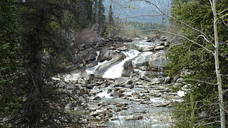
WAishihik Lake is a lake in southwestern Yukon, Canada. Yukon Electric Corporation operates a 37 megawatt hydroelectric dam at the south end of the lake, where it drains southward into the Aishihik River.
 W
WThe American Cordillera is a chain of mountain ranges (cordilleras) that consists of an almost continuous sequence of mountain ranges that form the western "backbone" of North America, South America and Central America. It is also the backbone of the volcanic arc that forms the eastern half of the Pacific Ring of Fire.
 W
WAmerican Scout Seamount appeared on charts of the North Atlantic Ocean published during the 1950s. It was located near 46°30′N 37°30′W with a depth of 37 meters. Investigations by the Woods Hole Oceanographic Institution research vessel Atlantis II in 1964 found no evidence that it existed.
 W
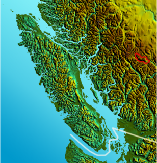
WThe Axelgold Range is a subrange of the Hogem Ranges of the Omineca Mountains, located between Ominicetla Creek and upper Omineca River in northern British Columbia, Canada.
 W
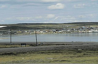
WBaker Lake is a lake in the Kivalliq Region, Nunavut, Canada. It is fed by the Thelon River from the west and the Kazan River from the south. Its outflows into Chesterfield Inlet. The lake is approximately 1,887 km2 (729 sq mi) in size. It has several named bays, and a few islands.
 W
WBaldy Mountain is the highest peak in Manitoba, Canada. It is located in the Duck Mountain Provincial Park, North of Grand View. It is 832 m (2,730 ft) tall, making it the highest mountain in the 563 km (350 mi) long Manitoba Escarpment.
 W
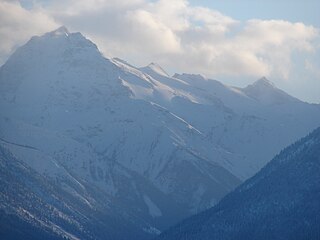
WThe Bendor Range is a small but once-famous subrange of the Pacific Ranges of the Coast Mountains, about It is approximately 7,000 square kilometres (2,700 mi²) in area and about 40 km long and about 18 km at its widest. It lies between Anderson Lake on the southeast and the Carpenter Lake Reservoir or the Bridge River Power Project on the north, with the gold-rich valley of Cadwallader Creek on its southwest.
 W
WBobs Lake is a lake in Frontenac County and Lanark County in Eastern Ontario, Canada. It is in the St. Lawrence River drainage basin and is the source of the Tay River.
 W
WBooming Ice Chasm is an ice cave, located in the Crowsnest Pass area of the Rocky Mountains in Alberta, Canada.
WThe Bornite Range is a subrange of the Bulkley Ranges, located just northeast of Terrace on the north side of Kleanza Creek in northern British Columbia, Canada.
 W
WCaledonia Mountain is 2,863-metre (9,393-foot) summit located in the Canadian Rockies on the shared border of Alberta and British Columbia in Canada. It is also situated on the shared boundary of Jasper National Park with Mount Robson Provincial Park. It is Alberta's 59th most prominent mountain. It was named in 1926 given its position overlooking the Caledonian Valley.
WThe Cariboo Heart Range is a subrange of the Hogem Ranges of the Omineca Mountains, located between Ominicetla Creek and Lion Creek in northern British Columbia, Canada.
WThe Cormier Range is a subrange of the Sifton Ranges, located between the Finlay River and Fox River in northern British Columbia, Canada. This northwest trending mountain range extends from Ware to Fox Pass.
WDefender Mountain is located on the border of Alberta and British Columbia on the Continental Divide.
 W
WDevils Paw is the high point of the Juneau Icefield, on the Alaska-British Columbia border. It is a part of the Boundary Ranges of the Coast Mountains. It is notable for its steep rise above the low local terrain. Its height is sometimes given as 8,507 feet.
 W
WThe Dickson Range is a subrange of the Chilcotin Ranges subset of the Pacific Ranges of the Coast Mountains in southwest-central British Columbia. It is located just west of the town of Gold Bridge between the valley of Slim Creek to the north and Downton Lake Reservoir to the south. At its eastern foot is Gun Lake; its western limit is at a pass between Slim Creek and Nichols Creek near the pass which separates the Bridge River basin from that of the Lord River, which feeds the Taseko Lakes.
 W
WHart Mountain in Manitoba is the highest peak in the Porcupine Hills of central Canada, with a max elevation of 823 m (2,700 ft). It is located 43 km (43,000 m) NNW of the Town of Swan River.
WThe Hogem Ranges are a group of mountain ranges in the northwest part of the Omineca Country of the North-Central Interior of British Columbia, Canada, located between Takla Lake (W) and the Omineca River (E) and from the Nation Lakes (SE) to the Sustut River (NW). The ranges have a collective area of 8868 km2 and is a subgrouping of the Omineca Mountains which in turn form part of the Interior Mountains.
WThe Horseranch Range is a 40 km (25 mi) long north-south trending mountain range in northern British Columbia, Canada, located at the head of the Red River to the northwest of Deadwood Lake. Part of the Dease Plateau of either the Yukon Plateau or Cassiar Mountains system, it contains no glaciers and lies completely above tree line.
 W
WThe Howson Range is a north-south trending subrange of the Bulkley Ranges of the Hazelton Mountains in northern British Columbia, Canada. It is located southwest of Telkwa Pass and southwest of Smithers. The highest summit in the range is Howson Peak 54 km (34 mi) southwest of Telkwa with an elevation of 2,759 m (9,052 ft).
 W
WThe Hozameen Range is a mountain range in southwestern British Columbia and northern Washington, straddling the division between the Coast and Interior regions of that province. It is a subrange of the North Cascades and is neighboured on the east by the Okanagan Range and on the northwest by the unofficially-named Coquihalla Range, which lies between that river and the Fraser. In the northwest part of the range is the one named subrange, the Bedded Range.
 W
WJackass Mountain is a mountain in the Canadian Cascades of the Cascade Range in southwestern British Columbia, Canada, located 18 km (11 mi) southeast of Lytton and 9 km (6 mi) south of Mount Lytton. It is named for the muletrains that ventured north to the Cariboo gold fields; apparently some did not make it over the bluff and perished in a fall, hence the name. The Cariboo Road was built over this route in 1862; the hill at 1200 feet sits high above the river, and like Nicaragua Bluff in the Canyon, makes a rugged rock of granite.
WMount Joffre is a mountain located on the Continental Divide, in Peter Lougheed Provincial Park, Alberta, and Elk Lakes and Height of the Rockies Provincial Parks in British Columbia. The mountain was named in 1918 by the Interprovincial Boundary Survey after Marshal Joseph Joffre, commander-in-chief of the French Army during World War I.
WMount John Oliver is a 3,123-metre (10,246 ft) mountain in the Premier Range of the Cariboo Mountains in the east-central interior of British Columbia, Canada. The mountain is located on the divide between the Kiwa and Tete Creeks and is covered by a glacier.
WMount Lester Pearson is a 3,086-metre (10,125 ft) mountain located in the Premier Range of the Cariboo Mountains in the east-central interior of British Columbia, Canada. The mountain is located south of the head of the McLennan River and 21 km (13 mi) west of Valemount, British Columbia.
 W
WMount Macdonald is a mountain peak located in the Selkirk Mountains of British Columbia, Canada, immediately to the east of Rogers Pass in Glacier National Park. It is notable as the location of the Canadian Pacific Railway's Connaught and Mount Macdonald Tunnels. At 14.7 km, the Mount Macdonald tunnel is the longest railway tunnel in the western hemisphere.
WMount Mackenzie King is a peak located in the Premier Range of the Cariboo Mountains in the east-central interior of British Columbia, Canada. The mountain separates the Laurier Glacier to the north from the David Glacier to the south.
 W
WThe Massive Range is a mountain range of the Canadian Rockies, located in the southwestern area of the Bow River valley in Banff National Park, Canada.
WMount Hood is a 2,903-metre (9,524-foot) mountain summit located in the Opal Range of the Canadian Rockies of Alberta, Canada.
WMount Nomad is a 2,544-metre (8,346-foot) mountain summit located in Peter Lougheed Provincial Park in the Canadian Rockies of Alberta, Canada.
 W
WMount Sir John Abbott is a 3,398 m (11,148 ft) mountain located in the Premier Range of the Cariboo Mountains in the east-central interior of British Columbia, Canada. It is located at the south end of the west wall of Kiwa Glacier, the source of Kiwa Creek.
 W
WMount Sir Sandford is the highest mountain of the Sir Sandford Range and the highest mountain in the Selkirk Mountains of southeastern British Columbia, Canada. It is the 12th highest peak in the province. The mountain was named after Sir Sandford Fleming, a railway engineer for the Canadian Pacific Railway.
WOnlsow Mountain is located on the border of Alberta and British Columbia on the Continental Divide.
 W
WThe Russel Range is a subrange of the Finlay Ranges of the Omineca Mountains, located between Finlay River and Pelly Creek in northern British Columbia, Canada.
 W
WMount Sir Wilfrid Laurier is the highest peak of the Cariboo Mountains in the east-central interior of British Columbia, Canada. The mountain is part of the Premier Range, which is located just west of Valemount.
 W
WMount Stanley Baldwin is a mountain located in the Premier Range of the Cariboo Mountains in the east-central interior of British Columbia, Canada. The mountain is located at the head of the Gilmour Glacier. It was originally named Mount Challenger by Allen Carpe during his 1924 ascent of the mountain.
 W
WThe Three Sisters Range is a subrange of the Stikine Ranges, located northwest of junction of the Stikine and McBride Rivers in northern British Columbia, Canada and to the southeast of the community of Dease Lake.
 W
WWatersheds of North America are large drainage basins which drain to separate oceans, seas, gulfs, or endorheic basins. There are six generally recognized hydrological continental divides which divide the continent into seven principal drainage basins spanning three oceans and one endorheic basin. The basins are the Atlantic Seaboard basin, the Gulf of Mexico basin, the Great Lakes-St. Lawrence basin, the Pacific basin, the Arctic basin, the Hudson Bay basin, and the Great Basin. Together, the principal basins span the continent with the exception of numerous smaller endorheic basins.