 W
WAkala Devi temple(Nepali :अकला देवी मन्दिर) is situated at Lamachaur, Pokhara. It is a three tiered roof built in Nepalese style. It is dedicated to Goddess Akala Devi.he Nepalese-style temple of Akala Devi at Lamachaur of Pokhara comprises three tiered roofs but is built of cement and bricks rather than wood. The temple is newly built. Originally, a small shrine honouring the goddess was present under a tree but this was later replaced by the present temple.
 W
WBaise Rajya were sovereign and intermittently allied petty kingdoms on the Indian subcontinent, ruled by Khas from medieval India, located around the Karnali-Bheri river basin of modern-day Nepal. The Baise were annexed during the unification of Nepal from 1744 to 1810. The kingdom's founder Prithvi Narayan Shah did not live to see this, but his son and grandson annexed the entire collection by the end of the 18th century.
 W
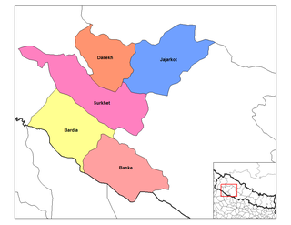
WBheri Zone was one of the fourteen zones located in the Mid-Western Development Region of Nepal. Nepalgunj were the administrative headquarters.
 W
WThe Bisnumati River, flowing in the Kathmandu Valley, originates at Tokha on Sivapuri Mountain, north of Kathmandu. It flows through the western part of old Kathmandu city. It is a holy river for both Hindu and Buddhist people. Literally, Bishnumati means the beloved river of Lord Vishnu. Sobha Baghwati and Indrayani along with Kankeshowri temple - a few of the holiest places of the Kathmandu Valley are on the opposite banks of this river. Karbir Masan, a revered cemetery is also on the bank of this river. the tributaries of this river are Sapanatirtha Khola, Sangle Khola, Lhora Khola and Binap fall. Bisnap fall locates at the Shivapuri National Park just above the Muhan Pokhari.
 W
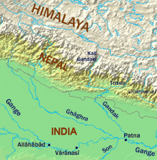
WThe Budhi Gandaki River is a tributary of Gandaki River in Nepal. It meets the Trishuli at the small named place of Benighat, astride Dhading and Gorkha Districts.
 W
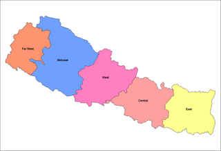
WThe Central Development Region was one of Nepal's five development regions. It was located in the east-central part of the country consisting of the capital city Kathmandu, along with its headquarters at Hetauda.
 W
WChhokangparo, or Chhokang Paro, is a small village nestled deep in the Tsum Valley of Gandaki Province; it is only just inside Nepal, as the Nepal-Chinese border is only 11.60 kilometres (7.21 mi) away when heading due north. The Mu-Chhule Nile river runs through the valley below.
 W
WChobhar caves are an extensive network of natural phreatic caves near the village of Chobhar, which is located 9 km southwest of Kathmandu, Nepal. Chobhar is also known for the Chobhar gorge through which all the water of the valley drains. A small temple of Adinath Sampradaya sits on top of a nearby hill. The temple offers a view of snow-capped mountains. According to Swayambhu Purana and legend, Kathmandu Valley was once a lake. It is believed that the bodhisattva Manjushree cut a gorge at a place called Chobhar Gorge, near Chobhar Ancient Hill Village and drained away the waters to establish a habitable land.
 W
WPrior to the promulgation of a new constitution in 2015 after earthquake in (andolan) when madheshi were aggressive.then, Nepal was divided into five development regions, 14 administrative zones and 75 districts. The 14 administrative zones were grouped into five development regions. Each district is headed by a Chief District Officer (CDO) responsible for maintaining law and order and coordinating the work of field agencies of the various government ministries.
 W
WDhorpatan Hunting Reserve is the only hunting reserve in Nepal. Established in 1987 it covers an area of 1,325 km2 (512 sq mi) in the Dhaulagiri Himal of western Nepal in the Rukum, Myagdi and Baglung Districts. In elevation, it ranges from 2,850 to 5,500 m.
 W
WDurbar Square, which means Royal Squares in English, is the generic name used to describe plazas and areas opposite the old royal palaces in Nepal. The name comes from Persian دربار (Darbar). It consists of temples, idols, open courts, water fountains and more. Before the Unification of Nepal, Nepal consisted of small kingdoms, and Durbar Squares are most prominent remnants of those old kingdoms in Nepal. In particular, three Durbar Squares in the Kathmandu Valley, belonging to the three Newar kingdoms situated there before unification, are most famous: Kathmandu Durbar Square, Patan Durbar Square, and Bhaktapur Durbar Square. All three are UNESCO World Heritage Sites.These sites have received significant damage due to the devastating earthquake of 2015 but most structures still remain.
 W
WThe East Rapti River flows from east to west through the Chitwan Valley in Nepal, forming the northern border of the Chitwan National Park. It joins the Narayani River inside the protected area.
 W
WGodawari River are two different rivers (tributaries), located in two different regions of Nepal.
 W
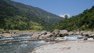
WHarpan Khola (river) is a tributary of Phewa Lake in Pokhara.
 W
WImja Glacier is located in the Himalayas, in the Solukhumbu District of Nepal.
 W
WThe Imja Khola is a tributary of the Dudh Kosi in Nepal. It drains the slopes of Mount Everest. The Khumbu Glacier melts into the Lobujya (Lobuche) River, which flows southward as the Imja Khola to its confluence with the Dudh Kosi at Tengboche.
 W
WThe Indravati River in Nepal is a tributary of the Sun Koshi River. It used to be called "Melamchi" or "Melamchu" until the 19th century.
 W
WKabeli River is a river in Taplejung District, Nepal. The river is 58 km long and basin size is about 900 km².
 W
WThe Khumbu Glacier is located in the Khumbu region of northeastern Nepal between Mount Everest and the Lhotse-Nuptse ridge. With elevations of 4,900 m (16,100 ft) at its terminus to 7,600 m (24,900 ft) at its source, it is the world's highest glacier. The Khumbu Glacier is followed for the final part of the trail to one of the Everest Base Camps. The start of the glacier is in the Western Cwm near Everest. The glacier has a large icefall, the Khumbu Icefall, at the west end of the lower Western Cwm. This icefall is the first major obstacle—and among the more dangerous—on the standard south col route to the Everest summit. It is also the largest glacier of Nepal.
 W
WLarkya La is one of the longest pass in Himalaya of Nepal, situated at 5,106 metres (16,752 ft) above the sea level. It is located in between Dharmashala and Bimthang, and is the highest point in the Manaslu Circuit Trek.
 W
WLhotse Shar is a glacier of the Himalayas in the Solukhumbu District of Nepal. It adjoins Imja Glacier to the northeast and with Ambulapcha Glacier forms three major glaciers. To the east is Cho Polu (6734m/22,093ft).
 W
WThe Likhu Khola is a left tributary of the Sun Koshi in the Himalayas in eastern Nepal. Given named by Kirat kingdom Likhu or Liku in the Sunuwar language means Top (Hill) Water.
 W
WThe Himachal Range – also called the Lower Himalayan Range or Lesser Himalaya – is a major east-west mountain range with elevations 3,700 to 4,500 m along the crest, paralleling the much higher High Himalayas range from the Indus River in Pakistan across northern India, Nepal and Bhutan but then the two ranges become increasingly difficult to differentiate east of Bhutan as the ranges approach the Brahmaputra River. The Himachal range also parallels the lower Shiwalik or Churia Range to the south. The Pir Panjal is the largest range of the Lesser Himalayas.
 W
WLumbini was one of the fourteen zones of Nepal until the restructure of zones to provinces. It is home to the Lumbini site, the birthplace of Siddhartha Gautama, who later became the historical Buddha and founder of the Buddhist philosophy. The zone's headquarters was Butwal.
 W
WMahashila Rural Municipality is a Gaunpalika in Parbat District in Gandaki of Nepal. On 12 March 2017, the government of Nepal implemented a new local administrative structure, with the implementation of the new local governance structure, Village Development Committees have been merged to form Municipalities and Gaunpalikas. Mahashila is one of these 753 local units. It is subdivided into 6 wards.
WMahendrapul is the financial hub and busiest high street of Pokhara. It is one of the oldest and busiest marketplaces in the city. It is one of the centre locations in the city. Mahendrapul is one of the most frequented marketplace in the whole of Pokhara. From clothing, Banking, jewellery to electronics. It is named after the Bridge named Mahendrapul. It is the bridge over Seti River and this bridge links Ranipauwa to Mahendrapool.
 W
WThe Marshyangdi is a mountain river in Nepal. Its length is about 150 kilometres.
WThe Mid-Western Development Region was one of the largest and formerly one of Nepal's five development regions. Westward from the Central region surrounding Kathmandu were the Western, Mid-Western and finally Far-Western regions. Counter-intuitively, Mid-Western lay west of Western.
 W
WMyagdi Khola is a river which has its source at Mt. Dhaulagiri, then passes through Myagdi district to meet to the Kaligandaki river. The term "myagdi" may be originated from the two terms Meng and dee. Meng means thapa magar and Dee means water in magar language. It is the everflow river. The term "khola" means, in local (Nepali) language river.
 W
WThe Ngozumpa glacier, below the sixth highest mountain in the world Cho Oyu in Nepal, at 36 kilometres (22 mi), is the longest glacier in the Himalayas. Ngozumpa Glacier is a large persistent body of ice. It flows slowly due to stresses induced by its weight.
 W
WSagarmāthā was one of the fourteen zones of Nepal until the restructuring of zones into provinces. The headquarters of Sagarmatha is Rajbiraj. Sagarmāthā is a Nepali word derived from सगर (sagar) meaning "sky" and माथा (māthā) meaning "head".
 W
WThe Seti River is an important tributary of the Karnali system that drains western Nepal.
 W
WThe Tamakoshi River is part of the Koshi or Sapt Koshi river system in Nepalese Himalayas. It originates from Rongshar Chu und Lapchi Gang rivers close to the Nepal-Tibet border. It flows in southern direction through Bagmati Pradesh in Nepal, namely through Dolakha District and Ramechhap District.
 W
WThe Tamor River is a major river in eastern Nepal, which begins around Kanchenjunga. The Tamor and the Arun join the Sun Koshi at Tribenighat to form the giant Saptakoshi which flows through Mahabharat Range on to the Gangetic plain
 W
WThuli Bheri River, a tributary of the Karnali River, starts in the Chharka region of Dolpa District where it is known as the Bhargung Khola (river).
 W
WThe Tinau is a Class- II category River originating from the Mahabharat Mountains and flowing through the Siwalik Hills and Terai Plain at Butwal, Nepal before joining the Ganges.
WThe Western Development Region was one of Nepal's five development regions. It was located in the west-central part of the country, with its headquarters located in Pokhara. This Development Region was divided into three parts, from south to north in order of increasing altitude: Terai, Hilly and Himalayan. Mustang, Damodar, Peri, Thaple, Ganesh are among the major ranges of the Himalayas.