 W
WThe Alde Feanen National Park is a national park in the Netherlands province of Friesland. The Alde Feanen is also a Natura 2000 area.
 W
WAmeland is a municipality and one of the West Frisian Islands off the north coast of the Netherlands. It consists mostly of sand dunes. It is the third major island of the West Frisians. It neighbours islands Terschelling to the west and Schiermonnikoog to the east. This includes the small Engelsmanplaat and Rif sandbanks to the east.
 W
WBargerveen Nature Reserve is a nature reserve in the Dutch province of Drenthe that has been included in the Natura 2000 ecological network. Since 2006 it is part of the Internationaler Naturpark Bourtanger Moor-Bargerveen, a nature reserve located on both sides of the border between the Netherlands and Germany. Most of the transboundary nature reserve, some 134 km2 (52 sq mi), lies in Germany, in the west of the state of Lower Saxony. The sparsely populated landscape consists of large peat areas, heather, and small lakes.
 W
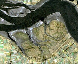
WThe Biesbosch National Park is one of the largest national parks of the Netherlands and one of the last extensive areas of freshwater tidal wetlands in Northwestern Europe. The Biesbosch consists of a large network of rivers and smaller and larger creeks with islands. The vegetation is mostly willow forests, although wet grasslands and fields of reed are common as well. The Biesbosch is an important wetland area for waterfowl and has a rich flora and fauna. It is especially important for migrating geese.
 W
WDunes of Texel National Park is a national park located on the North-Holland island of Texel in the Netherlands. All dune systems on the western side of the island and the large coastal plains on both the northern and southern points of the island are part of the park. The park covers approximately 43 km2 (17 sq mi) and attained national park status in 2002. The visitor center is located in the natural history museum Ecomare.
 W
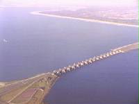
WThe Eastern Scheldt is a former estuary in the province of Zeeland, Netherlands, between Schouwen-Duiveland and Tholen on the north and Noord-Beveland and Zuid-Beveland on the south. It is also the largest national park in the Netherlands, founded in 2002.
 W
WGrevelingen or Grevelingenmeer is a closed off part of the Rhine-Meuse estuary on the border of the Dutch provinces of South Holland and Zeeland.
 W
WGriend is a small uninhabited Dutch island in the Wadden Sea, lying around 12 kilometres south of Terschelling. It is one of the West Frisian Islands, and belongs to the municipality of Terschelling. The island currently has an area of around 0.1 km2.
 W
WDe Groote Peel is a National Park in the Peel, a region in the Southeast of the Netherlands on the border between the provinces of Limburg and North Brabant. It has a size of 13,4 km² and preserves a peat bog that has remained partly untouched by peat cutting, which used to be extensive in the area.
 W
WThe Haringvliet is a large inlet of the North Sea, in the province of South Holland in the Netherlands. It is an important estuary of the Rhine-Meuse delta.
 W
WHollands Diep is a wide river in the Netherlands and an estuary of the Rhine and Meuse river. Through the Scheldt-Rhine Canal it connects to the Scheldt river and Antwerp.
 W
WThe IJmeer is a 'bordering lake' (Randmeer) in the Netherlands. It lies between the De Nes polder, Pampushaven, Hollandse Brug and the mouth of the IJ in IJburg, straddling the provinces of North Holland and Flevoland. It is an important habitat for birds such as the tufted duck and scaup. To the north-east is the Markermeer, south-east is the Gooimeer.
 W
WThe IJsselmeer, also known as Lake IJssel in English, is a closed off inland bay in the central Netherlands bordering the provinces of Flevoland, North Holland and Friesland. It covers an area of 1,100 km2 (420 sq mi) with an average depth of 5.5 m (18 ft). The river IJssel flows into the IJsselmeer.
 W
WThe Ketelmeer is the tongue of the IJsselmeer into which the River IJssel drains, it is situated between the polders Noordoostpolder and Oostelijk Flevoland, and connects the river IJssel to the IJsselmeer. It is one of the bordering lakes, a continuous body of water which separate Flevoland from the Noordostpolder and the ancient lands of the provinces of Gelderland and Utrecht. The Ketelmeer covers an area of 3500 hectares, most of which is in the province of Flevoland, but the river delta of the IJssel is in province of Overijssel.
 W
WKlein Bonaire is a small uninhabited islet off the west coast of the Caribbean island of Bonaire, and is part of the Dutch special municipality of Bonaire.
 W
WKlein Curaçao is a 1.7-square-kilometre uninhabited island belonging to, and lying 10 km south-east of, Curaçao, a constituent country of the Kingdom of the Netherlands in the Dutch Caribbean.
 W
WLac Bay is a shallow bay on the south-eastern coast of the island of Bonaire in the Caribbean Netherlands. It has a fringing reef at its mouth and contains about 100 ha of mangroves as well as a small harbour for fishing vessels. Its seagrass beds are used by sea turtles. It has been designated a Ramsar site as a wetland of international importance.
 W
WLauwersmeer is a man-made lake in the north of the Netherlands, on the border of the provinces of Groningen and Friesland. The lake was formed on 23 May 1969, when the dike between the bay called Lauwers Sea and the Wadden Sea was closed. It is noted for birdwatching.
 W
WLauwersmeer National Park is a national park in the provinces of Friesland and Groningen in the Netherlands. It consists of the southern and eastern parts of the Lauwersmeer.
 W
WThe Malpais–St Michiel Important Bird Area is a 1,100 ha tract of land, a former plantation just north of Sint Michiels Bay, on the southern coast of Curaçao, a constituent island nation of the Kingdom of the Netherlands in the Dutch Caribbean. It has been identified as an Important Bird Area by BirdLife International because it supports populations of bare-eyed pigeons, American coots, common terns and Caribbean elaenias, as well as a large brown-throated parakeet roost. It comprises two wetlands – a freshwater dam and a saline lagoon – with their surrounding thorn scrub vegetation. The waterbodies are used by a variety of waterbirds, including American flamingos, and the vegetation is used by resident and migratory passerines as well as by wintering raptors. The area has also been recognised as a Ramsar site as a wetland of international importance.
WThe Markermeer is a 700 km2 (270 sq mi) lake in the central Netherlands in between North Holland, Flevoland, and its smaller and larger neighbors, the IJmeer and IJsselmeer. A shallow lake at 3 to 5 m in depth, matching the reclaimed land to its west, north-west and east it is named after the small former island, now peninsula, of Marken on its west shore.
 W
WThe Muizenberg Important Bird Area comprises a 150 ha wetland area, including an intermittent shallow lake (Muizenberg) and smaller pond. The site lies within the northern suburbs of Willemstad, the capital of Curaçao, a constituent island nation of the Kingdom of the Netherlands in the Dutch Caribbean. It has been identified as an Important Bird Area by BirdLife International because it supports American coots. Common moorhens, pied-billed grebes and white-cheeked pintails breed there and American flamingos feed there. The 64 ha Muizenberg lake has been recognised as a wetland of international importance by designation as a Ramsar site.
 W
WThe Oostvaardersplassen is a nature reserve in the Netherlands, which is managed by the State Forestry Service. Covering about 56 square kilometres (22 sq mi), it is noted as an experiment of rewilding. It is in a polder which was created in 1968; by 1989, its ecological interest had resulted in its being declared a Ramsar wetland. It became part of Nieuw Land National Park when it was created in 2018.
 W
WThe Pelkermeer Saltworks is a 6,851 ha saltern at the southern end of the island of Bonaire in the Caribbean Netherlands. Originally a series of natural shallow lagoons, it has been modified over centuries to enable salt production. It has been identified as an Important Bird Area (IBA) by BirdLife International. Within the saltern there is a 55 ha reserve established to protect a breeding colony of about 5,000 American flamingos. The IBA also supports populations of least, common, sandwich and royal terns, as well as large numbers of migratory waders. The saltern has been designated a Ramsar site as a wetland of international importance.
 W
WSaeftinghe or Saaftinge was a town in the southwest Netherlands, located in eastern Zeelandic Flanders, near Nieuw-Namen. It existed until 1584. It is now a swamp known as the Drowned Land of Saeftinghe and an official nature reserve area. The land is a crosspoint where the river Scheldt meets the salty waters of the North Sea in the estuary Western Scheldt. It is a treacherous place where the tides easily consume large stretches of land in a matter of seconds and must not be explored without an experienced guide.
 W
WThe Scheldt is a 350-kilometre-long (220 mi) river that flows through in northern France, western Belgium, and the southwestern part of the Netherlands, with its mouth at the North Sea. Its name is derived from an adjective corresponding to Old English sceald ("shallow"), Modern English shoal, Low German schol, West Frisian skol, and Swedish (obsolete) skäll ("thin").
 W
WSchiermonnikoog National Park is a national park in the Dutch province of Friesland. It was founded in 1989. It covers about 72 km2 (28 sq mi), the majority of the island Schiermonnikoog.
 W
WSimpson Bay Lagoon is one of the largest inland lagoons in the West Indies of the Caribbean. It is located on the island of Saint Martin. The border between the French and Dutch halves of the island runs across the centre of the lagoon. There are two small islands that lie in the lagoon: the larger, Grand Ilet to the north, is within the French region of Saint-Martin; the smaller, Little Key, to the south, is on the Dutch Sint Maarten side.
 W
WTerschelling is a municipality and an island in the northern Netherlands, one of the West Frisian Islands. It is situated between the islands of Vlieland and Ameland.
 W
WThe Veerse Meer is a lagoon in the southwest Netherlands, in the province of Zeeland. It was separated from the North Sea in 1961 by the Delta Works dam system.
 W
WVlieland is a municipality and island in the northern Netherlands. The municipality of Vlieland has one major town, Oost-Vlieland. It is the second most sparsely populated municipality in the Netherlands, after Schiermonnikoog.
 W
WThe Wadden Sea National Parks in Denmark, Germany and the Netherlands are located along the German Bight of the North Sea. In Germany and Denmark they also mark the area of the UNESCO World Heritage Site of the Wadden Sea. Divided from each other by administrative borders, they form a single ecological entity. The purpose of the national parks is the protection of the Wadden Sea ecoregion.
 W
WThe Weerribben-Wieden National Park is a national park of the Netherlands in the Steenwijkerland municipality of the province of Overijssel. Comprising the largest bog of northwestern Europe, the park consists of two areas, De Weerribben and De Wieden, and has an area of roughly 100 square kilometres (39 sq mi). The park was founded in 1982, but De Wieden was added only in 2009.
 W
WThe Western Scheldt in the province of Zeeland in the southwestern Netherlands, is the estuary of the Scheldt river. This river once had several estuaries, but the others are now disconnected from the Scheldt, leaving the Westerschelde as its only direct route to the sea. The Western Scheldt is an important shipping route to the Port of Antwerp, Belgium. Unlike the Eastern Scheldt estuary, it could not be closed off from the sea by a dam as part of the Delta Works. Instead, the dykes around it have been heightened and reinforced.
 W
WThe Wolderwijd is a bordering lake situated in the Netherlands, created in 1967 by the gaining of land in Southern Flevoland. It is one of four Veluwe bordering lakes. On the northern and western bank it is encompassed by the municipality of Zeewolde, in the Province of Flevoland, and on the southern and eastern bank it is encompassed by the municipality of Harderwijk in the Province of Gelderland. As the bordering lakes of Flevoland are strictly speaking one mass of water there are no exact markers on where the Wolderwijd ends and the adjacent lakes start. In the west near Strand Horst the Wolderwijd becomes the Nuldernauw and in the east at the aqueduct at the provincial road N302 it becomes the Veluwemeer.
 W
WZuidlaardermeer is a lake in the northern part of the Netherlands.