 W
WBačka is a geographical and historical area within the Pannonian Plain bordered by the river Danube to the west and south, and by the river Tisza to the east. It is divided between Serbia and Hungary. Most of the area is located within the Vojvodina region in Serbia and Novi Sad, the capital of Vojvodina, lies on the border between Bačka and Syrmia. The smaller northern part of the geographical area is located within Bács-Kiskun County, in Hungary.
 W
WBács-Kiskun is a county located in southern Hungary. It was created as a result of World War II, merging the pre war Bács-Bodrog and the southern parts of Pest-Pilis-Solt-Kiskun counties. With an area of 8,445 km2, Bács-Kiskun is the largest county in the country. The terrain is mostly flat with slight emergences around Baja. The county seat and largest city of Bács-Kiskun is Kecskemét.
 W
WThe North Bačka District is one of seven administrative districts of the autonomous province of Vojvodina, Serbia. It lies in the Bačka geographical region. According to the 2011 census results, it has a population of 186,906 inhabitants. The administrative center of the district is the city of Subotica.
 W
WThe South Bačka District is one of seven administrative districts of the autonomous province of Vojvodina, Serbia. Geographically it lies in the southern part of Bačka and northern part of Syrmia. According to the 2011 census results, it has a population of 615,371 inhabitants. The administrative center of the district is the city of Novi Sad, which is also the capital and the largest city of the Autonomous Province of Vojvodina.
 W
WThe West Bačka District is one of seven administrative districts of the autonomous province of Vojvodina, Serbia. It lies in the geographical region of Bačka. It has a population of 188,087 inhabitants. The administrative seat of the district is the city of Sombor.
 W
WThe Bođani Monastery is a Serbian Orthodox monastery in the Bačka region, in the northern Serbian province of Vojvodina. The monastery is near the village of Bođani, in the Bač municipality. Among the few Serbian Orthodox monasteries in the Bačka, Bođani is the oldest.
 W
WBunjevci are a South Slavic ethnic group living mostly in the Bačka region of Serbia and southern Hungary. They presumably originate from western Herzegovina, whence they migrated to Dalmatia, and from there to Lika and Bačka in the 17th century. Bunjevci who remained in Bosnia and Herzegovina, as well as those in modern Croatia today maintain that designation chiefly as a regional identity, and declare as ethnic Croats. Those who emigrated to Hungary were largely assimilated, and assumed Hungarian or Croatian designation. Bunjevci are mainly Roman Catholic, and speak the Bunjevac dialect of Serbo-Croatian with Ikavian pronunciation and with certain archaic characteristics. During the 18th and 19th century, they formed a sizable part of the population of northern Bačka, but many of them were gradually assimilated into larger ethnic groups in the region.
 W
WThe Čik or Čiker is a river in northern Serbia. A 95 km (59 mi) long right tributary to the Tisa river, it flows entirely within the Bačka region of Vojvodina province.
 W
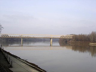
WThe Danube is Europe's second-longest river, after the Volga. It is located in Central and Eastern Europe.
 W
WThe Danube–Criș–Mureș–Tisa Euroregion is a euroregion located in Hungary, Romania and Serbia. It is named after four rivers: Danube, Criș, Mureș and Tisa.
 W
WDanube–Tisa–Danube Canal (DTD) is a canal system in Serbia. It is a unique hydro-engineering system for flood control and hydrotechnical management, amelioration, forestry, water supply, waste water evacuation, navigation, tourism, fishing, hunting.
 W
WThe Eparchy of Bačka is an ecclesiastical territory or eparchy of the Serbian Orthodox Church in the Bačka region, Serbia. It is situated in the autonomous province of Vojvodina and seat of the eparchy is in Novi Sad.
 W
WGemenc is a unique forest that is found between Szekszárd and Baja, in Hungary. This is the only remaining tidal area of the Danube in Hungary. The wood's fauna include stags, boars, storks, grey herons, gyrfalcons, white-tailed eagles, and kites. Various amphibians and reptiles can also be found. The stag population has worldwide fame, since its genetic stock is outstanding, and the stags' antlers are impressive. Due to the various watery habitats, many fish species are present.
 W
WGornje Podunavlje Special Nature Reserve is a large protected area of wetland in the northwest of Serbia, on the Danube's left bank. It comprises two large marshes, Monoštorski Rit and Apatinski Rit and vast forests, meadows, ponds, swamps and the Danube's meanders, including 66 km (41 mi) of the Danube course. It is projected as a part of the future trans-boundary biosphere reserve "Mura-Drava-Danube", a five country project, dubbed the "Amazon of Europe".
 W
WGreat Bačka Canal is a canal in Serbia which runs from Bezdan to Bečej. The canal is 118 km long and part of the Danube-Tisa-Danube Canal system. The excavation works of Great Bačka Canal began in 1794 and went on until 1801 in Bács-Bodrog County, Kingdom of Hungary. The Bed of the canal is 17 m wide and 25 m wide at the top. The average depth is 3 m. The water of the canal is very polluted because it runs through industrial towns, such as Vrbas, Kula and Crvenka.
 W
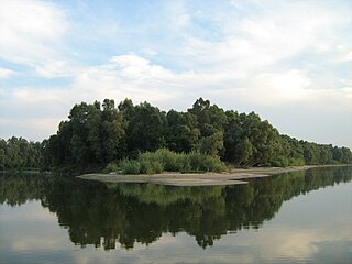
WIsland of Krčedin or Krčedinska Ada is a river island in Serbia. It is located on the left bank of the Danube across the village of Krčedin, in the municipality of Inđija, Autonomous Province of Vojvodina. The uninhabited island is part of the Special Natural Reserve "Koviljsko-Petrovaradinski Rit". It is one of the largest remaining natural pastures in the Podunavlje, known for the traditional stock breeding, with only basic human interference.
 W
WThe Jegrička, is a river in northern Serbia, in the Bačka region of the Vojvodina province, a 65-kilometre long (40 mi) right tributary to the Tisa river.
 W
WThe Jegrička Nature Park is a nature park in the north of Serbia along the Jegrička river the Bačka region of the Vojvodina province. The river is often lyrically referred to as "the umbilical cord of the Bačka wetlands" and is therefore declared a nature park. It covers the area along the river's banks and runs through four municipalities: Bačka Palanka, Vrbas, Temerin and Žabalj.
 W
WThe Körös-ér or Kereš, is a river in southern Hungary and northern Serbia, a 90-kilometre-long (56 mi) right tributary to the Tisa river. It flows entirely within the Bačka region of both Hungary and Serbia (Vojvodina): 37 km (23 mi) in Hungary, 15 km (9.3 mi) as a border river and 29 km (18 mi) in Serbia.
 W
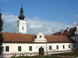
WThe Kovilj Monastery is a 13th-century Serb Orthodox monastery in the Bačka region, in the northern Serbian province of Vojvodina. According to the legend, the monastery was founded by the first Serb archbishop, Saint Sava in the 13th century. The monastery, often cited as one of the most beautiful, has been nicknamed the "Jewel of Bačka". Considered "one of the most monumental cultural-historical objects in Bačka", it is protected by the state since 4 August 1949 as the cultural monument.
 W
WThe Krivaja is a river in northern Serbia. With the length of 109 km (68 mi) it is the longest river that flows completely within the borders of Serbian province of Vojvodina.
 W
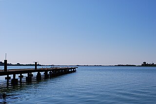
WLake Palić is a lake 8 kilometres (5.0 mi) from Subotica, near the town of Palić, in Serbia. It covers an area of 3.8 square kilometres (1.5 sq mi). The average depth of the lake is 2 metres.
 W
WLittle Bačka Canal, is a canal in Serbia which runs from Mali Stapar to Novi Sad. The canal is 66 km long and it is part of Danube-Tisa-Danube Canal system. The canal shortens waterway from Bezdan to Novi Sad by 75 km. Little Bačka Canal has 4 sluices. In the past, the canal was named after emperor Franz Josef and king Alexander.
 W
WThe Mostonga is a river in northern Serbia, in Bačka region of the province of Vojvodina, a 70-km long left tributary to the Danube. Once 92 km long, due to the extensive corrections and channeling of the river to make it part of the other canals, the Mostonga is shortened, turned into a series of channels and popularly referred to as a river there is no more.
 W
WNovi Sad Airport, also known as Čenej Airport, is located near the village of Čenej in Serbia. At the moment, the site is mostly used for sport and agriculture.
 W
WThe Pannonian Basin, or Carpathian Basin, is a large basin in Central Europe. The geomorphological term Pannonian Plain is more widely used for roughly the same region though with a somewhat different sense, with only the lowlands, the plain that remained when the Pliocene Epoch Pannonian Sea dried out.
 W
WThe Plazović or Kiđoš, is a river in southern Hungary and northern Serbia. It flows entirely within the Bačka region, and during its 129 km long course, on a section of only 15 km, it crosses the Hungarian-Serbian border eight times.
 W
WPotisje is the name of the Tisa river basin parts located in Serbia, in the autonomous province of Vojvodina. The river Tisa flow between Banat and Bačka regions.
 W
WThe Roman Catholic Diocese of Subotica is a diocese of the Roman Catholic Church in Serbia. It is subject to the Roman Catholic Archdiocese of Belgrade. The Diocese is centered in the city of Subotica. Slavko Večerin currently serves as bishop.
 W
WŠajkaška (Шајкашка) is a historical region in northern Serbia. It is southeastern part of Bačka, located in the Autonomous Province of Vojvodina. Territory of Šajkaška is divided among four municipalities: Titel, Žabalj, Novi Sad, and Srbobran. Historical center of Šajkaška is Titel.
 W
WSombor Airport is an airport in Serbia, located 7 km from the city of Sombor and 9 km from the town of Apatin between villages Kupusina and Prigrevica.
 W
WThe Tisza, Tysa or Tisa, is one of the main rivers of Central and Eastern Europe. Once, it was called "the most Hungarian river" because it flowed entirely within the Kingdom of Hungary. Today, it crosses several national borders.
 W
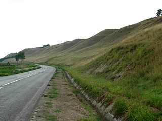
WTitelski Breg or Titel Hill is a loess plateau situated in the Vojvodina province, Serbia. It is located in south-eastern Bačka, between the town of Titel in the south, the villages of Lok, Vilovo and Šajkaš in the south-west, the village of Mošorin in the north, and the river Tisa in the east. It is 18 km long and 7.5 km wide, with steep cliffs, up to 60 m high along the Tisa. The hill has a flat top with an elevation of around 100 to maximally 128 m. The cliffs and the flat top give it a mesa-like appearance. The hill is an interesting geographical feature because it is the only hill in Bačka region, most of which is a flat plain. It is a loess formation deposited during the Pleistocene, showing six distinct bands, visible in gullies at the edge.