 W
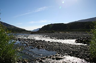
WThe Acheron River is a river in the South Island of New Zealand, in Marlborough and flows into the Clarence River. It flows southwest and then east for a total of 60 kilometres (37 mi), joining the Clarence at the southern end of the Inland Kaikoura mountains. The Alma and Severn Rivers flow into the Acheron before it joins the Clarence.
 W
WAllports Island is a small uninhabited island located in Queen Charlotte Sound in Marlborough, New Zealand. It reaches a height of 79 metres (259 ft) and is 1 kilometre (0.62 mi) from the New Zealand mainland. An even smaller unnamed island lies immediately to the east of it. Both islands are covered in native bush.
 W
WThe Awatere River is a large river flowing through Marlborough, New Zealand. Flowing along the trace of the active Awatere Fault, it runs northeast through a straight valley to the west of the Inland Kaikoura mountains. This valley is parallel with that of the Clarence River, 20 kilometres (12 mi) to the south.
 W
WThe Blairich River is a river in the Marlborough district of New Zealand. It is a tributary of the Awatere River
 W
WThe Bryant Range is a range of low mountains in the northern South Island of New Zealand. They form part of the boundary of the Nelson and Tasman Districts with Marlborough Region, as well as forming the western boundary of Mount Richmond Forest Park The range is traversed by State Highway 6 at the Rai Saddle close to its northern end.
 W
WCape Campbell, Te Karaka in the Māori language, is in Marlborough, New Zealand, on the northeastern coast of the South Island. It lies at the southern end of Clifford Bay, 15 kilometres (9 mi) northeast of Ward, and 42 kilometres (26 mi) southeast of Blenheim. Cape Campbell lies close to the salt works at Lake Grassmere.
 W
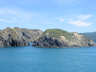
WCape Jackson is a peninsula in Marlborough, in the South Island of New Zealand. It lies between Queen Charlotte Sound and Cook Strait.
 W
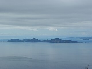
WThe Chetwode Islands are a group of islands near the Marlborough Sounds along the northern coast of the South Island of New Zealand.
 W
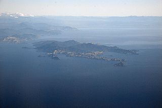
WRangitoto ki te Tonga / D'Urville Island is an island in the Marlborough Sounds along the northern coast of the South Island of New Zealand. It was named after the French explorer Jules Dumont d'Urville. With an area of approximately 150 square kilometres (58 sq mi), it is the eighth-largest island of New Zealand, and has around 52 permanent residents. The local authority is the Marlborough District Council.
 W
WFairhall is a locality in Marlborough, New Zealand. Blenheim is about 7.5 km to the northeast. The Fairhall River runs past to the west.
 W
WFairy Bay is east of Mount Stanley, elevation 971 metres (3,186 ft), in Pelorus Sound / Te Hoiere, part of the Marlborough Sounds Maritime Park, at the top of the South Island, New Zealand. The origin of the name is thought to have been the fairy penguin. A neighbouring bay immediately to the south is called Penguin Bay.
 W
WThe Flaxbourne River is a river in the Marlborough region of New Zealand. It arises in the Inland Kaikoura Range and Halden Hills and flows east and then south-east into the South Pacific Ocean near Ward. It is named after the Flaxbourne sheep station established by Sir Charles Clifford in 1847. The river is narrow and choked with willows.
 W
WForsyth Island lies in the outer Marlborough Sounds of New Zealand's South Island and is separated from the mainland by the 300m wide Allen Strait. The island comprises a mixture of farm land and native bush on hills rising to over 350 metres (1,148 ft) with views into the Marlborough Sounds and east towards the North Island.
WGrovetown is a small town in Marlborough, New Zealand. State Highway 1 runs past the settlement to the west, and the Wairau River flows past to the northeast. Spring Creek is about 2.5 km to the north, and Blenheim is about 3.5 km to the south. To the east is Grovetown Lagoon, an oxbow loop of the Wairau River. The settlement had a usual resident population of 357 at the 2018 New Zealand census.
 W
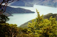
WKenepuru Sound is one of the larger of the Marlborough Sounds in the South Island of New Zealand. The drowned valley is an arm of Pelorus Sound / Te Hoiere, it runs for 25 kilometres (16 mi) from the northeast to southwest, joining Pelorus Sound a quarter of the way down the latter's path to the Cook Strait.
WKoromiko is a locality in Marlborough, New Zealand. State Highway 1 runs through the area. Picton is about 6.5 km (4.0 mi) to the northeast, and Blenheim is about 21 km (13 mi) to the south.
 W
WThe Marlborough Sounds Important Bird Areas are four distinct sites comprising several small, rocky islets contained within an area with a maximum linear extent of 40 km, in New Zealand. They lie close to Cook Strait in the outer Marlborough Sounds at the northern end of the South Island. The sites are Duffers Reef, Sentinel Rock, White Rocks and the Trio Islands. They have been identified as Important Bird Areas (IBAs) by BirdLife International because they hold the only known colonies, and encompass the entire breeding range, of the vulnerable rough-faced shag.
 W
WThe Medway River is a river of the Marlborough Region of New Zealand's South Island. It flows northwest then north from its sources in the Inland Kaikoura Range to meet the Awatere River 20 kilometres (12 mi) southwest of Seddon.
WMoenui is a small settlement 3 km east of Havelock in the South Island of New Zealand. It is situated on the shores of the Mahikipawa arm of the Mahau Sound - one of the many sounds in the Marlborough Sounds. The meaning of Moenui is "Big Sleep".
 W
WTe Hoiere / Pelorus River is a river at the northern end of South Island of New Zealand in the region of Marlborough. It flows from the Richmond Range into Pelorus Sound. This area is fantastic for camping and is renowned for its magnificent river swimming where the Pelorus River runs through a gorge at Pelorus Bridge.
 W
WPenzance Bay is a popular bay located in Tennyson Inlet, within the Marlborough Sounds. Tennyson Inlet is an arm of Pelorus Sound. The bay is immediately north of Tuna Bay which is accessed by the same road.
 W
WThe Rangitoto Islands are a group of islands near the Marlborough Sounds along the northern coast of the South Island of New Zealand.
WRapaura is a village northwest of Blenheim, New Zealand. The Wairau River flows past to the north. Spring Creek lies to the east.
WRiverlands is a locality in Marlborough, New Zealand. State Highway 1 runs through the settlement, and the Ōpaoa River flows past to the northeast. Blenheim is about 2.5 km to the northwest.
 W
WRNZAF Base Woodbourne is a base of the Royal New Zealand Air Force, located 8 km west of Blenheim.
WTapuae-o-Uenuku, formerly Mount Tapuaenuku, is the highest peak in the northeast of New Zealand's South Island. The name translates from Māori as "footprint of the rainbow", though is usually regarded as being named after Chief Tapuaenuku.
 W
WThe Taylor River is one of the two rivers that flow across the Wairau Plain into Blenheim, New Zealand, where it joins the Ōpaoa River. It arises near Taylor Pass to the south of the Wither Hills and flows north-east and north. The river and pass were named for Joseph Taylor, a New Zealand Company surveyor who worked in the area from 1842.
 W
WThe Wairau River is one of the longest rivers in New Zealand's South Island. It flows for 170 kilometres (110 mi) from the Spenser Mountains, firstly in a northwards direction and then northeast down a long, straight valley in inland Marlborough.
 W
WThe Wakamarina River is a river of the Marlborough Region of New Zealand's South Island. It flows generally northeast from its origins in the Richmond Range to reach the Pelorus River at the settlement of Canvastown, 10 kilometres (6 mi) west of Havelock. In 1864, gold was found in the river near Havelock, and soon 6,000 men were working in the area. The gold rush did not last long and most miners moved on to the West Coast Gold Rush.
 W
WWest Head is the name of three separate headlands on New Zealand's South Island.43°40′38″S 173°04′20″E, at the entrance to Okains Bay on Banks Peninsula. 41°13′02″S 174°08′37″E, at the end of a peninsula on the northern shore of Queen Charlotte Sound. 41°12′57″S 174°18′55″E, a rocky headland at the entrance to Tory Channel.
WWharanui is a small village located in Marlborough on the east coast of New Zealand's South Island between Ward and Kaikoura. State Highway 1 and the Main North Line railway both pass through the village.