 W
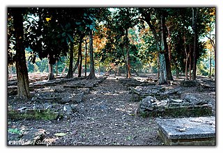
WBhalukpung is a small town located along the southern reaches of the Himalayas in West Kameng district of Arunachal Pradesh in India. The town is located at 213m above sea level, 100 km from Bomdila, 52 km from Tezpur and 5 km from Tipi. It lies along the Kameng river and is the headquarters of Bhalukpung circle. A road leads to Bomdila via the Tipi Orchidariurm, and the inner line check post is located at Bhalukpung. It has a railway station namely Bhalukpong Railway Station, connected to Rangiya Murkongselek rail line at Balipara. It has 3 platforms. One pair of trains runs daily to and from here.
 W
WD'Ering Memorial Wildlife Sanctuary is a protected area in Arunachal Pradesh, India, with an area of 190 km2 (73 sq mi). It was established in 1978.
 W
WDambuk is a Tehsil in the Indian state of Arunachal Pradesh. Lower Dibang Valley is the name of the district that contains Tehsil Dambuk.
WDeomali is a census town in Tirap district in the state of Arunachal Pradesh, India. The small sub-divisional town has scenic beauty and is surrounded by hills, tea gardens, forests and rivers.
 W
WDibang River, also known as Talo in Idu, is a tributary river of the Brahmaputra that originates and flows through the Mishmi Hills and northeast India from the state of Arunachal Pradesh.
WThe Dibang Wildlife Sanctuary is one of the eight wildlife sanctuaries of Arunachal Pradesh, India. It is located in the Upper Dibang Valley district covering an area of 4,149 km2 (1,602 sq mi). The sanctuary is rich in wildlife. Rare mammals such as Mishmi takin, red goral, musk deer, red panda, Asiatic black bear, occasional tiger and Gongshan muntjac occur while among birds there are the rare Sclater's monal and Blyth's tragopan. A flying squirrel, new to science has been recently discovered from the edge of this sanctuary. It has been named the Mishmi Hills giant flying squirrel. Dibang Wildlife Sanctuary is located fully or partly within Dihang-Dibang Biosphere Reserve
WDihang-Dibang or Dehang-Debang is a biosphere reserve constituted in 1998. It is in the Indian state of Arunachal Pradesh. The Mouling National Park and the Dibang Wildlife Sanctuary are located fully or partly within this biosphere reserve. The reserve spreads over three districts: Dibang Valley, Upper Siang, and West Siang. It covers high mountains of Eastern Himalaya and Mishmi Hills. The elevation in the reserve ranges up to more than 5,000 metres (16,000 ft) above sea level. An important fact relating to this Biosphere reserve is that it has natural vegetation stretching in an unbroken sequence from the tropics to mountain tundra. The type of vegetation found in this biosphere reserve can be grouped as 1. Sub-tropical broad leafed forests, 2. Sub tropical pine forest, 3. Temperate broad leafed forests, 4. Temperate conifer, 5. Sub-alpine woody shrub, 6. Alpine meadow( mountain Tundra), 7. Bamboo brakes, 8. Grassland. The habitat in Dihang-Dibang ranges from tropical wet evergreen in the river gorges to subtropical, temperate, alpine and permanent snow.
 W
WEast Siang is an administrative district in the state of Arunachal Pradesh in India.
WEtalin is a small village in the Dibang Valley district. It is located in the Indian state of Arunachal Pradesh It is a rest stop used by those taking the route to Anini or Malinye. Etalin is approximately 52 km from Anini and approximately 42 km from Malinye. The nearest hospital is the Anini General Hospital.There is one middle school in etalin and for further study they have to move to Anini High secondary School or Roing High Secondary School, the nearest airport is in Assam (Mohanbari)
WGandhigram, locally known as Shidi, is a village inhabited by Lisu people in Vijoynagar circle, Changlang district, Arunachal Pradesh, India. The population was 1,754 at the 2011 Indian census. There is no road connectivity to the nearest town, Miao, and it is a five- or six-day walk.
 W
WGanga Lake or Geker Sinying is a lake in Itanagar, the capital of Arunachal Pradesh. It is one of the most popular places in Itanagar. People from all around visit this place as a recreation spot and for the picture perfect view of this lake. Because the lake is still with no connection with moving water bodies, its color is green. Many mythological rumors about the Ganga Lake and its color are heard still. This lake is also known as Gyakar Sinyi and it houses wonderful works of nature.
 W
WJairampur cemetery is a World War II cemetery in Arunachal Pradesh, India. It is located 7 km from Jairampur, Changlang district, and 25 km from Pangsau Pass, the Indo-Myanmar Border on the road to Ledo,27°18′53″N 96°03′09″E. It was discovered in 1997.
WJomlo Bari is a small village reside at West Siang District, Arunachal Pradesh.
 W
WKangto at 7,060 metres (23,163 ft) is a mountain of the Eastern Himalayas located in the Indian state of Arunachal Pradesh and it shares its border with the Tibet Autonomous Region of China. It is the highest point in Arunachal Pradesh. The area in which Kangto is located lies in the Sawa circle of East Kameng district of the state. On the Chinese side, it lies in Cona County of Shannan Prefecture, Tibet.
WKerang Village is a small village reside at West Siang District, Arunachal Pradesh.
WKharsang is a circle under the Miao sub-division of Changlang district of Arunachal Pradesh. The inhabitants of the district are mainly Tangsa tribe. [Tea]] plantations being the main source of income for the locals. Surrounded by beautiful hills, rivers and greenery it has the potential to be a tourist hotspot if the resources are used efficiently. The area is also rich in minerals such as coal and petroleum, it has an oil field under Geo-Enpro Petroleum Ltd. spread over an area of 11 square km.
WKhonsa is the headquarters of Tirap district in the Indian state of Arunachal Pradesh. It also houses Ramakrishna Sarada Mission School, Christ The King ICSE School.The Noctes, a Wancho tribe, are the indigenous population, although the town is cosmopolitan in nature, people from every Indian state can be found here.
 W
WKimin is a populated place in the Papum Pare district of Arunachal Pradesh, India. It is centre of one of the nine administrative circles of the district. It is located at a distance of approximately 75 kilometres from Itanagar, the capital of Arunachal Pradesh. The nearest train station and to reach Kimin is North Lakhimpur and Domestic airport is Lilabari, which falls in state of Assam. Drive time will take 35mins approx. Good hotels are scarce in Kimin, though cheap good food are available in plenty. Hindi is widely spoken here. Ideal time to visit Kimin is November to February, when the weather becomes very pleasant.
WKumki is a town in Arunachal Pradesh in the district of Changlang. It is one of the easternmost permanently populated towns of India.
 W
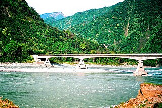
WThe Lohit River or Zayü River is a river in India and China. It is a tributary to the Brahmaputra River. The river rises in Tibet Autonomous Region, in the Kangri Garpo range, where it is known as the Zayü River. It descends through this mountainous region and surges through Arunachal Pradesh in India for 200 kilometres (120 mi) before entering the plains of Assam where it is known as the Lohit River for 200 km (120 mi). Tempestuous and turbulent, and known as the river of blood partly attributable to the lateritic soil, it flows through the Mishmi Hills, to meet the Siang (Brahmaputra) at the head of the Brahmaputra valley covering 400 km (250 mi)of distance.
WNyegyi Kansang is a mountain of the Eastern Himalayas located in the Arunachal Pradesh state of India on the border with Tibet, China. Nyegyi Kansang has an elevation of 7,047 metres (23,120 ft).
 W
WPapum Pare district is an administrative district in the state of Arunachal Pradesh in India. As of 2011, it is the most populous district of Arunachal Pradesh.
WRani Village or Rani is a small village located in the Sille-Oyan circle of East Siang district, Arunachal Pradesh with a total of 924 residing families. It is situated 12 km from the district headquarter Pasighat and the 3rd largest village in the East Siang district, after Riga Village and Mirem Village.
WSeppa is the headquarters of the East Kameng district in the state of Arunachal Pradesh in India. Sapla means 'marshy' land in the local dialect. It lies on the bank of Kameng River and there is a helipad there. It is located 160 kilometres (99 mi) from Itanagar and 213 kilometres (132 mi) from Tezpur (Assam) connected by motorable road. Map p 22 The village of Seppa has 2 out of the 60 Vidhan Sabha Constituencies of Arunachal Pradesh. They are Seppa East and Seppa West.
WSine is a village in the Boleng Circle of East Siang District, Arunachal Pradesh.
 W
WThe Subansiri River is a tributary of the Brahmaputra River in the Indian states of Assam and Arunachal Pradesh, and the Tibet Autonomous Region of China. The Subansiri is 442 kilometres (275 mi) long, with a drainage basin 32,640 square kilometres (12,600 sq mi) large. The Subansiri is the largest tributary of the Brahmaputra. Its maximum observed discharge was 18,799 cubic metres per second (663,900 cu ft/s), and its minimum 131 m3/s (4,600 cu ft/s). It contributes 7.92% of the Brahmaputra's total flow.
WTalle Valley Wildlife Sanctuary is a protected area in Arunachal Pradesh, India, with an area of 337 km2 (130 sq mi). It was established in 1995. It is also known as Talley Valley Wildlife Sanctuary. It ranges in elevation from 1,200 to 3,000 m and harbours subtropical and temperate broadleaved and conifer forests. Mammal species present include clouded leopard, Malayan giant squirrel, Indian muntjac and Asian palm civet. The 130 bird species observed in spring 2015 included black eagle, collared owlet, golden-breasted fulvetta, scarlet minivet, Verditer flycatcher and Mrs. Gould's sunbird.
WWakro is a village in Wakro circle of the Lohit district in Arunachal Pradesh state of India. The PIN code of Wakro is 792102. Wakro is connected by two national highways, National Highway 13 and National Highway 15
WYupia is the headquarters of Papum Pare district in the state of Arunachal Pradesh in India. Yupia is about 20 km from Itanagar, the state capital.