 W
WThe geography of Paris is characterized by the urbanization of the area it lies within, and its position in the Petite Couronne, Grande Couronne, and Île-de-France.
 W
WThe revolutionary sections of Paris were subdivisions of Paris during the French Revolution. They first arose in 1790 and were suppressed in 1795.
 W
WThe Axe historique is a line of monuments, buildings, and thoroughfares that extends from the centre of Paris, France, to the west. It is also known as the Voie Triomphale.
 W
WThe Bassin de l'Arsenal is a boat basin in Paris. It links the Canal Saint-Martin, which begins at the Place de la Bastille, to the Seine, at the Quai de la Rapée. A component of the Réseau des Canaux Parisiens, it forms part of the boundary between the 4th and the 12th arrondissements. It is bordered by the Boulevard Bourdon on the 4th (westerly) side and the Boulevard de la Bastille on the 12th (easterly) side.
 W
WThe Boulevard de la Bastille is the southwesternmost street of the 12th arrondissement of Paris, situated in the quartier called Quinze-Vingts. It overlooks the east side of the Paris marina, known as the Port de Plaisance or Port de l'Arsenal, with which it forms a boundary with the 4th arrondissement of Paris. The boulevard also lies directly north of the border between the 5th arrondissement and the 13th arrondissement of Paris.
 W
WThe Boulevards of the Marshals are a collection of thoroughfares that encircle the city of Paris, France, just inside its city limits. Most bear the name of a marshal of the First French Empire (1804–1814) who served under Napoleon I. The Île-de-France tramway Lines 3a and 3b today run on of the Boulevards of the Marshals.
 W
WThe Butte-aux-Cailles is a hilltop neighbourhood of Paris, France located in Paris' south-eastern 13th arrondissement. A now extinct river, the Bièvre, once made this area important for the tannery and tissue trades.
 W
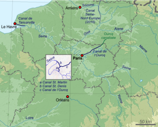
WThe Canal de l'Ourcq is a 108.1 km (67.2 mi) long canal in the Île-de-France region with 10 locks. It was built at a width of 3.20 m (10.5 ft) but was enlarged to 3.7 m (12 ft), which permitted use by more pleasure boats. The canal begins at Port-aux-Perches near the village of Troesnes, where it splits from the channeled River Ourcq, and flows to the Bassin de la Villette, where it joins the Canal Saint-Martin. Paris requires 380 000 m3 of water daily for cleaning the sewer system, gutters, and parks. The Canal de l'Ourcq provides about half of the requirement. Since 1983, the waterway has been designated for use by pleasure craft, and its water is designated for non-drinking uses.
 W
WThe Canal Saint-Denis is a canal in Paris that is 6.6 kilometres (4.1 mi) in length. The canal connects the Canal de l'Ourcq, at a point north-northwest of the Bassin de la Villette in the 19th arrondissement, with the suburban municipalities of Saint-Denis and Aubervilliers in the department of Seine-Saint-Denis. There are seven locks along the canal's route, and, near Saint-Denis, the canal discharges into the Seine.
 W
WThe Canal Saint-Martin is a 4.6 km long canal in Paris, connecting the Canal de l'Ourcq to the river Seine. Over nearly half its length, between the Rue du Faubourg du Temple and the Place de la Bastille, it was covered, in the mid-19th century, to create wide boulevards and public spaces on the surface. The canal is drained and cleaned every 10–15 years, and it is always a source of fascination for Parisians to discover curiosities and even some treasures among the hundreds of tonnes of discarded objects.
 W
WThe Walls of Paris refers to the city walls that surrounded Paris, France, as it grew from ancient times until the 20th century, built primarily to defend the city but also for administrative reasons. Several successive city walls were built over the centuries, either adding to existing walls or replacing demolished ones, through 1846, when construction of the Thiers wall was completed. The city walls of Paris include:a Gaulish enclosure a Gallo-Roman wall two medieval walls, one of which was the Wall of Philippe Auguste the Wall of Charles V, extending on the right bank of the River Seine the Louis XIII Wall, extending on the western part of the right bank the Wall of the Farmers-General, for tax purposes the Thiers wall.
 W
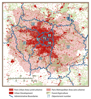
WThe city of Paris had a population of 2,187,526 people within its administrative city limits as of January 1, 2017. It is surrounded by the Paris unité urbaine, or urban area, the most populous urban area in the European Union. In 2017 the unité urbaine had a population of 10,784,830. The Paris Region, or Île-de-France covers 12,012 square kilometers, and has its own regional council and president. It has a population of 12,174,880 as of January 2017, or 18.3 percent of the population of France.
 W
WThe fortifications of Paris in the 19th and 20th centuries comprise:The Thiers Wall, surrounding the city of Paris, and farther from the city, The detached forts and their complementary fieldworks.
 W
WThe Métropole du Grand Paris is an administrative structure for cooperation covering the City of Paris and its nearest surrounding suburbs. The métropole came into existence on January 1, 2016 and comprises 131 communes, including the City of Paris, all 123 communes in the surrounding inner-suburban departments of the Petite Couronne, plus seven communes in two of the outer-suburban departments, including the communes of Argenteuil in Val-d'Oise, and Paray-Vieille-Poste in Essonne, the latter of which covers part of Orly Airport. Part of the métropole comprised the Seine department, which existed from 1929 to 1968. Grand Paris covers 814 square kilometers and has a population of 7 million.
WThe Paris metropolitan area is a statistical area that describes the reach of commuter movement to and from Paris, France and its surrounding suburbs.
 W
WLutetian limestone — also known as “Paris stone” — is a variety of limestone particular to the Paris, France, area. It has been a source of wealth as an economic and versatile building material since ancient Roman times and has contributed markedly to the unique visual appeal of the “City of Light”. Its formation dates to the Eocene epoch's Lutetian age. The name "Lutetian" derives from Lutetia which was the city's name in ancient times.
 W
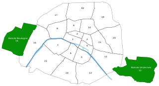
WThe mines of Paris comprise a number of abandoned, subterranean mines under Paris, France, connected together by galleries. Three main networks exist; the largest, known as the grand réseau sud, lies under the 5th, 6th, 14th and 15th arrondissements, a second under the 13th arrondissement, and a third under the 16th, though other minor networks are found under the 12th, 14th and 16th for instance. The commercial product was Lutetian limestone for use as a building material, as well as gypsum for use in "plaster of Paris".
 W
WThe "Histoire de Paris" plaques are information plaques scattered throughout the City of Paris in front of various Parisian monuments.
 W
WThe Paris meridian is a meridian line running through the Paris Observatory in Paris, France – now longitude 2°20′14.03″ East. It was a long-standing rival to the Greenwich meridian as the prime meridian of the world. The "Paris meridian arc" or "French meridian arc" is the name of the meridian arc measured along the Paris meridian.
WThe Paris metropolitan area is a statistical area that describes the reach of commuter movement to and from Paris, France and its surrounding suburbs.
 W
WÎle-de-France is the most populous of the 18 regions of France. It is located in the north-central part of the country and often called the Région Parisienne because it includes the city of Paris. Île-de-France is densely populated and economically important: it covers only 12,012 square kilometres but has an official estimated population of 12,278,210, and accounts for 31% of French gross domestic product (GDP).
 W
WThe Porte d'Orléans is one of 17 portes in the Thiers wall, a defensive wall constructed in the mid-nineteenth century to protect Paris. The wall was demolished after the First World War, creating an open space that was subsequently built up. The Porte d'Orléans is now one of the main gateways to the capital, and is located in the 14th arrondissement of Paris.
 W
WThe Quai Voltaire is a street located in the 7th arrondissement of Paris. 308 meters long, it lies between the Quai Malaquais and Quai Anatole-France. The Quai Voltaire begins at the Rue des Saints-Pères and ends at the Rue de Bac and the Pont Royal.
 W
WLa Rive Droite is most commonly associated with the river Seine in central Paris. Here the river flows roughly westwards, cutting the city into two: when facing downstream, the northern bank is to the right, and the southern bank is to the left.
WThe Rive Gauche is the southern bank of the river Seine in Paris. Here the river flows roughly westward, cutting the city in two: when facing downstream, the southern bank is to the left, and the northern bank is to the right.
 W
WThe Thiers wall was the last of the defensive walls of Paris. It was an enclosure constructed between 1841 and 1846 and was proposed by the French prime minister Adolphe Thiers but was actually implemented by his successor. The 33 kilometres (21 mi) long wall and ditch made a complete circuit around the city as it stood at the time of the July Monarchy. It was bombarded by the Prussian Army during the Franco-Prussian War, captured by government troops during the Paris Commune and refortified at the start of the First World War. However, by then it had become obsolete as a fortification, was a barrier to the expansion of the city, and the area immediately outside of it, known as "the zone", had become a shanty town. The wall was demolished in the interwar period; its path today can be traced by the Boulevards of the Marshals which originally ran just behind the fortifications and by the Boulevard Périphérique which was later built just outside. A few remnants of the wall can still be seen.
 W
WThe wall of Charles V, built from 1356 to 1383 is one of the city walls of Paris. It was built on the right bank of the river Seine outside the wall of Philippe Auguste. In the 1640s, the western part of the wall of Charles V was demolished and replaced by the larger Louis XIII wall, with the demolished material reused for the new wall. This new enclosure (enceinte) was completely destroyed in the 1670s and was replaced by the Grands Boulevards.
 W
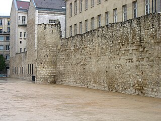
WThe Wall of Philip Augustus is the oldest city wall of Paris (France) whose plan is accurately known. Partially integrated into buildings, more traces of it remain than of the later fortifications.