 W
WThe Argentina–Brazil border is the line that limits the territories of Argentina and Brazil. It is approximately 1,224 km (761 mi) long.
 W
WThe Atlantic Coast restingas is an ecoregion of the tropical and subtropical moist broadleaf forests biome, and the South American Atlantic Forest biome. It is located along Brazil's Atlantic coast, from the country's northeast to its southeast.
 W
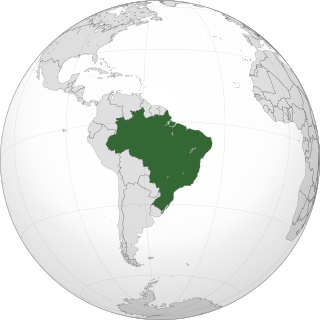
WThe borders of Brazil are the international borders that Brazil shares with neighboring countries. Brazil has borders with ten countries, every country in South America with the exception of Chile and Ecuador, totaling 16,885 kilometres (10,492 mi). Brazil has the world's third longest land border, behind China and Russia.
 W
WThe border between Brazil and Colombia is 1,644.2 km (1,021.7 mi) long. The boundary was delimited in two treaties:the Vásquez Cobo-Martins treaty of 1907, establishing the line from the Rio Negro northwestward along the Amazon River-Orinoco watershed divide, "then generally southward along various river courses and straight-line segments to the mouth of the Apaporis River", and the Tratado de Límites y Navegación Fluvial of 1928, delimiting the Apaporis-Amazon segment of the boundary as a "geodesic line identical to its Brazilian-Peruvian antecedent after Colombia gained undisputed sovereignty over the area".
 W
WThe Brazil–Peru border is the line, located in the Amazon Rainforest, that limits the territories of Brazil and Peru. The Brazilian states of Amazonas and Acre border the eastern Peruvian regions of Loreto, Ucayali and Madre de Dios. Part of the limit was established in the Treaty of Rio de Janeiro in 1909.
 W
WThe Brazil–Uruguay border is a strip of land located south of the southern Brazilian state of Rio Grande do Sul. It stretches for 985 km from the triple border Brazil-Argentina-Uruguay west to the mouth of Arroyo Chuí, the southernmost point in Brazil.
 W
WThe Brazilian Highlands or Brazilian Plateau are an extensive geographical region, covering most of the eastern, southern and central portions of Brazil, in all approximately half of the country's land area, or some 4,500,000 km2. In addition, the vast majority of Brazil's population lives in the highlands or on the narrow coastal region immediately adjacent to it.
 W
WCentro-Sul is the Southeastern, Southern and Central-West regions of Brazil, excluding the north of Minas Gerais and most of Mato Grosso and along with some of Tocantins.
 W
WThe drought in the Northeast region of Brazil is a natural phenomenon resulting from lack of rain in the NE region of Brazil, which has high temperatures with low rainfall during the year. The escarpment act as an obstruction to the winds blowing from the sea and cause orographic type of rainfall in the coastal region. Beyond the highlands,the effect of these winds get reduced. As a result,the rainfall is minimal. This region is a rain shadow region. Hence,it is also called as Drought Quadrilateral. This region extends from northern Bahia to coast between Natal and Sao Luis; that zone receives about 15-30 inches (375-750mm) of precipitation a year.
 W
WLagoon Mirim or Merín is a large estuarine lagoon which extends from southern Rio Grande do Sul state in Brazil into eastern Uruguay. Lagoa Mirim is separated from the Atlantic Ocean by a sandy, partially barren isthmus.
WLagosta Field is an oil and gas field located in the Santos Basin of southeastern Brazil. The field was discovered in July 2003 and was operated by El Paso Corp. oil company, holding a 60% stake with Petrobras owning the other 40%. Later, the field passed to Petrobras as operator. The field is estimated to contain 0.173 trillion cubic feet of gas, and 35.16 million barrels of oil in the Itajaí-Açu Formation. The field, located next to the Merluza Field, the first discovery in the Santos Basin in 1979, started development in 2009.
 W
WThe Meio-norte is one of the four subregions of northeast Brazil. It is a climatic transition area located between the equatorial Amazon and semi-arid hinterlands.
 W
WParcel das Paredes is a large submerged bank in Brazil with an area of about 200 km2. It is a coralline structure located in the Atlantic Ocean off the shore near Caravelas, Bahia State.
 W
WRestinga — a spit and a distinct type of coastal Tropical and subtropical moist broadleaf forest, found in eastern Brazil.
WThe Sapinhoá oil field is an oil field located in the southern Brazilian Santos Basin, 310 kilometres (190 mi) off the coast of Rio de Janeiro in a water depth of 7,065 feet (2,153 m). It was discovered in 2008 and originally named Guará field, under development by Petrobras. The oil field is operated by Petrobras and owned by Petrobras (45%) Repsol Sinopec Brazil (25%) and BG Group (30%). The total proven reserves of the Sapinhoá oil field range from 1,100–2,000 million barrels.
 W
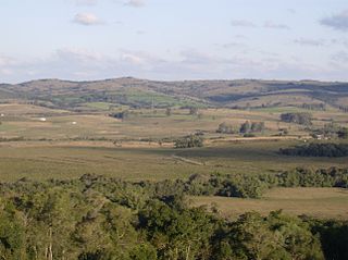
WThe Uruguayan savanna, also known as the Brazilian-Uruguayan savanna, is a subtropical grassland and savanna ecoregion which includes all of Uruguay, some areas of northeastern Argentina and southernmost Brazil.
WThe Zona da Mata is the narrow coastal plain between the Atlantic Ocean and the dry agreste and sertão regions in the northeastern Brazilian states of Maranhão, Piauí, Rio Grande do Norte, Paraíba, Pernambuco, Alagoas, Sergipe and Bahia.