 W
WAlgeria comprises 2,381,741 square kilometers of land, more than four-fifths of which is desert, in northern Africa, between Morocco and Tunisia. It is the largest country in Africa. Its Arabic name, Al Jazair, derives from the name of the capital Algiers, after the small islands formerly found in its harbor. It has a long Mediterranean coastline. The northern portion, an area of mountains, valleys, and plateaus between the Mediterranean Sea and the Sahara Desert, forms an integral part of the section of North Africa known as the Maghreb. This area includes Morocco, Tunisia, and Libya.
 W
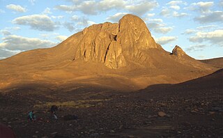
WAtakor volcanic field is a volcanic field in Algeria. It lies in the Hoggar mountains and consists of a variety of volcanic features such as lava flows and about 450 individual vents which create a spectacular scenery.
 W
WAurès is an Amazigh language-speaking natural region located in the mountainous area of the Aurès range in eastern Algeria. The region includes the Algerian provinces of Batna, Tebessa, Khenchela, Oum El Bouaghi, Souk Ahras and Biskra.
 W
WCape Caxine is a cape located in Algeria.
 W
WCorniche Jjilienne is a natural region of northern Algeria characterised by rocky forested massifs rising above the coastal plain. The forested areas provide some of the last extant habitat for the endangered Barbary macaque, Macaca sylvanus; this primate prehistorically had a much wider distribution in North Africa than at present.
 W
Wel-Djerid, al-Jarīd or more precisely the South Western Tunisia Region is a semi-desert natural region comprising three southern Tunisian Governorates, Gafsa, Kebili and Tozeur with adjacent parts of Algeria and Libya.
 W
WGuerrouch is a region of Algeria within the Petite Kabylie of the Tell Atlas Mountain Range. The Guerrouch is one of the few remaining habitats for the endangered primate Barbary macaque, Macaca sylvanus; prehistorically this primate had a much wider distribution, prior to deforestation activity by the expanding human population.
 W
WThe Hautes Plaines, also known as Hauts Plateaux, is a steppe-like natural region located in the Atlas Mountains in northern Algeria. It stretches more than 600 km (370 mi) in an east northeast – west southwest direction from northeastern Morocco to the Aures. It is a high plateau area consisting of undulating, steppe-like alluvial plains lying between the Tell and Saharan Atlas ranges.
 W
WThe Hodna is a natural region of Algeria located between the Tell and Saharan Atlas ranges at the eastern end of the Hautes Plaines. It is a vast depression lying in the northeastern section of M'Sila Province and the western end of Batna Province.
 W
WThe M'zab or Mzab,, is a natural region of the northern Sahara Desert in Ghardaïa Province, Algeria. It is located 600 km (370 mi) south of Algiers and there are approximately 360,000 inhabitants.
 W
WMenaceur is a small town and commune in Algeria, situated about 100 km west of Algiers. Menaceur has a population of 40,000. The Bouchanoun River passes through Menaceur. Nearby mountains include Zabrir, el Pic, Boumaad, and Tizi Franco.
 W
WThe Paris meridian is a meridian line running through the Paris Observatory in Paris, France – now longitude 2°20′14.03″ East. It was a long-standing rival to the Greenwich meridian as the prime meridian of the world. The "Paris meridian arc" or "French meridian arc" is the name of the meridian arc measured along the Paris meridian.
 W
WPetite Kabylie or Petite Kabylia is a natural region in the mountainous area of northern Algeria. The Petite Kabylie is part of the greater Kabylie region.
 W
WThe South Saharan steppe and woodlands, also known as the South Sahara desert, is a deserts and xeric shrublands ecoregion of northern Africa.
 W
WThe Tanezrouft is a natural region located along the borders of Algeria, Niger and Mali, west of the Hoggar mountains. It is one of the most desolate parts of the Sahara Desert.
 W
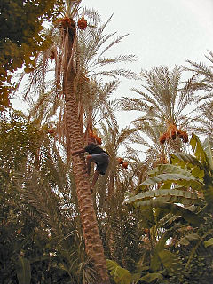
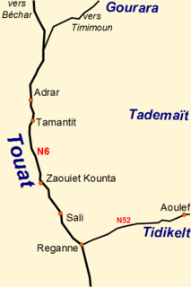
WTuat, or Touat, is a natural region of desert in central Algeria that contains a string of small oases. In the past, the oases were important for caravans crossing the Sahara.