 W
WThe geology of Iceland is unique and of particular interest to geologists. Iceland lies on the divergent boundary between the Eurasian plate and the North American plate. It also lies above a hotspot, the Iceland plume. The plume is believed to have caused the formation of Iceland itself, the island first appearing over the ocean surface about 16 to 18 million years ago. The result is an island characterized by repeated volcanism and geothermal phenomena such as geysers.
 W
WElephant Rock is a natural rock near Heimaey island, Iceland.
 W
WThe Eurasian Plate is a tectonic plate which includes most of the continent of Eurasia, with the notable exceptions of the Indian subcontinent, the Arabian subcontinent, and the area east of the Chersky Range in East Siberia. It also includes oceanic crust extending westward to the Mid-Atlantic Ridge and northward to the Gakkel Ridge.
 W
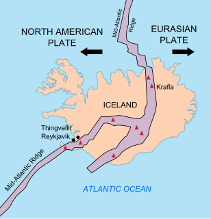
WThe geological deformation of Iceland is the way that the rocks of the island of Iceland are changing due to tectonic forces. The geological deformation explains the location of earthquakes, volcanoes, fissures, and the shape of the island. Iceland is the largest landmass (102,775 km²) situated on an oceanic ridge. It is an elevated plateau of the sea floor, situated at the crossing of the Mid-Atlantic Ridge and the Greenland-Iceland-Faeroe Ridge. It lies along the oceanic divergent plate boundary of North American Plate and Eurasian Plate. The western part of Iceland sits on the North American Plate and the eastern part sits on the Eurasian Plate. The Reykjanes Ridge of the Mid-Atlantic ridge system in this region crosses the island from southwest and connects to the Kolbeinsey Ridge in the northeast.
 W
WHelgustadir mine is a mine in the east of Iceland where Iceland spar was mined from the mid-17th century to the 20th century. It is the source of the largest and clearest known Iceland spar specimen and the source of most museum specimens of Iceland spar.
 W
WThe Iceland hotspot is a hotspot which is partly responsible for the high volcanic activity which has formed the Iceland Plateau and the island of Iceland.
 W
WThe North American Plate is a tectonic plate covering most of North America, Greenland, Cuba, the Bahamas, extreme northeastern Asia, and parts of Iceland and the Azores. With an area of 76 million km2 (29 million sq mi), it is the Earth's second largest tectonic plate, behind the Pacific Plate.
 W
WThe North Atlantic Igneous Province (NAIP) is a large igneous province in the North Atlantic, centered on Iceland. In the Paleogene, the province formed the Thulean Plateau, a large basaltic lava plain, which extended over at least 1.3 million km2 (500 thousand sq mi) in area and 6.6 million km3 (1.6 million cu mi) in volume. The plateau was broken up during the opening of the North Atlantic Ocean leaving remnants existing in Northern Ireland, bits of western Scotland, the Faroe Islands, bits of northwestern Iceland, eastern Greenland and western Norway and many of the islands located in the north eastern portion of the North Atlantic Ocean. The igneous province is the origin of the Giant's Causeway and Fingal's Cave. The province is also known as Brito-Arctic province and the portion of the province in the British Isles is also called the British Tertiary Volcanic Province or British Tertiary Igneous Province.
 W
WÞingvellir was the site of the Alþiing, the annual parliament of Iceland from 930AD until the last session held at Þingvellir in 1798AD. Since 1881, the parliament has been located within Alþingishúsið in Reykjavik.
 W
WThe Reykjanes Peninsula in southwest Iceland is the continuation of the mostly submarine Reykjanes Ridge, a part of the Mid-Atlantic Ridge, on land and reaching from Esja in the north and Hengill in the east to Reykjanestá in the west. Suðurnes is an administrative unit covering part of Reykjanes Peninsula.
 W
WSilfra is a rift formed in the divergent tectonic boundary between the North American and Eurasian plates and is located in the Þingvallavatn Lake in the Þingvellir National Park in Iceland.
WÞingvellir was the site of the Alþiing, the annual parliament of Iceland from 930AD until the last session held at Þingvellir in 1798AD. Since 1881, the parliament has been located within Alþingishúsið in Reykjavik.