 W
WBalochistan is an arid desert and mountainous region in south-western Asia. It comprises the Pakistani province of Balochistan, the Iranian province of Sistan and Baluchestan, and the southern areas of Afghanistan, including Nimruz, Helmand and Kandahar provinces. Balochistan borders the Pashtunistan region to the north, Sindh and Punjab to the east, and Persian regions to the west. South of its southern coastline, including the Makran Coast, are the Arabian Sea and the Gulf of Oman.
 W
WBengal is a geopolitical, cultural and historical region in South Asia, specifically in the eastern part of the Indian subcontinent at the apex of the Bay of Bengal. Geographically, it is made up by the Ganges-Brahmaputra delta system, the largest such formation in the world; along with mountains in its north bordering the Himalayan states of Nepal and Bhutan and east bordering Burma.
 W
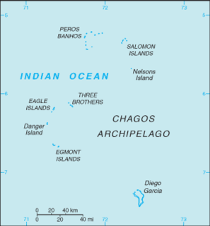
WThe British Indian Ocean Territory (BIOT) is an archipelago of 55 islands in the Indian Ocean, located south of India. It is situated approximately halfway between Africa and Indonesia. The islands form a semicircular group with an open sea towards the east. The largest, Diego Garcia, is located at the southern extreme end. It measures 60 square kilometres (23 sq mi) and accounts for almost three-quarters of the total land area of the territory. Diego Garcia is the only inhabited island and is home to the joint UK-US naval support facility. Other islands within the archipelago include Danger Island, Three Brothers Islands, Nelson Island, and Peros Banhos, as well as the island groups of the Egmont Islands, Eagle Islands, and the Salomon Islands.
 W
WThe geology of the Himalaya is a record of the most dramatic and visible creations of modern plate tectonic forces. The Himalayas, which stretch over 2400 km between the Namcha Barwa syntaxis in Tibet and the Nanga Parbat syntaxis in Kashmir, are the result of an ongoing orogeny — the result of a collision of the continental crust of two tectonic plates. This immense mountain range was formed by tectonic forces and sculpted by weathering and erosion. The Himalaya-Tibet region supplies fresh water for more than one-fifth of the world population, and accounts for a quarter of the global sedimentary budget. Topographically, the belt has many superlatives: the highest rate of uplift, the highest relief, among the highest erosion rates at 2–12 mm/yr, the source of some of the greatest rivers and the highest concentration of glaciers outside of the polar regions. This last feature earned the Himalaya its name, originating from the Sanskrit for "the abode of the snow".
 W
WThe Himalayas, or Himalaya, , is a mountain range in Asia separating the plains of the Indian subcontinent from the Tibetan Plateau. The range has many of Earth's highest peaks, including the highest, Mount Everest, at the border between Nepal and China. The Himalayas include over fifty mountains exceeding 7,200 m (23,600 ft) in elevation, including ten of the fourteen 8,000-metre peaks. By contrast, the highest peak outside Asia is 6,961 m (22,838 ft) tall.
 W
WThe Indian subcontinent, or, sometimes simply called the subcontinent, is a physiographical region in southern Asia, situated on the Indian Plate and projecting southwards into the Indian Ocean from the Himalayas. Geologically, the Indian subcontinent is related to the landmass that rifted from the supercontinent Gondwana during the Cretaceous and merged with the Eurasian landmass nearly 55 million years ago. Geographically, it is the peninsular region in south-central Asia, delineated by the Himalayas in the north, the Hindu Kush in the west, and the Arakanese in the east. Geopolitically, the Indian subcontinent generally includes all or part of Bangladesh, Bhutan, India, Nepal, Pakistan and Sri Lanka, as well as Maldives. The terms "Indian subcontinent" and "South Asia" are sometimes used interchangeably to denote the region.
 W
WKāfiristān, or Kāfirstān, is a historical region that covered present-day Nuristan Province in Afghanistan and its surroundings. This historic region lies on, and mainly comprises, the basins of the rivers Alingar, Pech (Kamah), Landai Sin and Kunar, and the intervening mountain ranges. It is bounded by the main range of the Hindu Kush on the north, Pakistan's Chitral District to the east, the Kunar Valley in the south and the Alishang River in the west.
 W
WThe Maldive Islands is a group of islands in the Indian Ocean composing today's Republic of Maldives and the island of Minicoy in the Union Territory of Lakshadweep.
 W
WNepal measures about 880 kilometers (547 mi) along its Himalayan axis by 150 to 250 kilometers across. It has an area of 147,181 square kilometers (56,827 sq mi).However,the government of Nepal puts it at 1,47,516.
 W
WPunjab is a geopolitical, cultural, and historical region in South Asia, specifically in the northern part of the Indian subcontinent, comprising areas of eastern Pakistan and northern India. The boundaries of the region are ill-defined and focus on historical accounts.