 W
WAkunnat is a former community in southern Greenland on the island of Akonemiok or Qeqertarsuatsiaat, 3 miles (4.8 km) from the trading post of Fisher's Inlet.
WAlluitsoq is the name of a former settlement in southern Greenland, located on the Alluitsoq or Lichtenau Fjord near Cape Farewell. It is about 13 kilometers from Ammassivik (Sletten), located on the opposite side of the same fjord.
WAnnoatok or Anoritooq, located at 78°33′N 72°30′W, was a small hunting station in Greenland on Smith Sound about 24 km (15 mi) north of Etah. It is now abandoned.
 W
WAppaalissiorfik is a former settlement in the Qaasuitsup municipality in northwestern Greenland. It was located in the north-central part of Upernavik Archipelago, on the southwestern cape of Qullikorsuit Island, an island in Tasiusaq Bay. The settlement operated between 1916 and 1923.
 W
WAtaa was a settlement in the Disko Bay region of western Greenland. It was located on the eastern coast of Alluttoq Island, approximately 60 km (37 mi) to the north of Ilulissat and 30 km (19 mi) to the southeast of Qeqertaq.
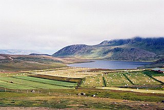
WBrattahlíð, often anglicised as Brattahlid, was Erik the Red's estate in the Eastern Settlement Viking colony he established in south-western Greenland toward the end of the 10th century. The present settlement of Qassiarsuk, approximately 5 km (3.1 mi) southwest from the Narsarsuaq settlement, is now located in its place. The site is located about 96 km (60 mi) from the ocean, at the head of the Tunulliarfik Fjord, and hence sheltered from ocean storms. Erik and his descendants lived there until about the mid-15th century. The name Brattahlíð means "the steep slope".
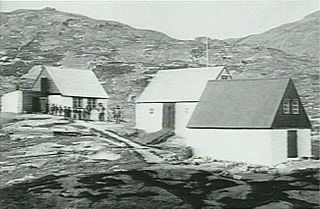
WBrønlundhus, on some maps also Brønlundfjord, is a former research station and radio station located on the western shore of Jørgen Brønlund Fjord in southern Peary Land, in northern Greenland. It is named after Greenlandic Arctic researcher Jørgen Brønlund, or after the namesake fjord on which it is located. It is close to the mouth of Jørgen Brønlund Fjord where it opens into Independence Fjord.
 W
WClavering Island is a large island in eastern Greenland off Gael Hamke Bay, to the south of Wollaston Foreland.
WComer's Midden was a 1916 archaeological excavation site near Thule, north of Mt. Dundas in North Star Bay in northern Greenland. It is the find after which the Thule culture was named. The site was first excavated in 1916 by whaling Captain George Comer, ice master of the Crocker Land Expedition's relief team, and of members of Knud Rasmussen's Second Danish Thule Expedition who were in the area charting the North Greenland coast.
 W
WDyrnæs was a Norse settlement in Eastern Settlement in Greenland. It was located to the north of modern-day Narsaq.
WThe Eastern Settlement was the first and by far the largest of the two main areas of Norse Greenland, settled c. AD 985-1000 by Norsemen from Iceland. At its peak, it contained approximately 4,000 inhabitants. The last written record from the Eastern Settlement is of an Icelandic/Greenlandic wedding in Hvalsey in 1408, placing it about 50–100 years later than the end of the more northern Western Settlement.
 W
WEtah is an abandoned settlement in the Avannaata municipality in northern Greenland. It was a starting point of discovery expeditions to the North Pole and the landing site of the last migration of the Inuit from the Canadian Arctic.
 W
WGarðar was the seat of the bishop in the Norse settlements in Greenland. It is a Latin Catholic titular see.
WHerjolfsnes was a Norse settlement in Greenland, 50 km northwest of Cape Farewell. It was established by Herjolf Bardsson in the late 10th century and is believed to have lasted some 500 years. The fate of its inhabitants, along with all the other Norse Greenlanders, is unknown. The site is known today for having yielded remarkably well-preserved medieval garments, excavated by Danish archaeologist Paul Norland in 1921. Its name roughly translates as Herjolf's Point or Cape.
WHvalsey is located near Qaqortoq, Greenland and is the site of Greenland's largest, best-preserved Norse ruins in the area known as the Eastern Settlement (Eystribyggð).
WIkermiut is a former settlement in the Qaasuitsup municipality in northwestern Greenland. It was located on Ikermiut Island in the center of Inussulik Bay, a bay in the northern part of Upernavik Archipelago. The settlement was abandoned in 1954 in favor of more northerly settlements of Nuussuaq and Kullorsuaq, due to rough sea waves of Inussulik Bay overflowing the island.
WIkigait is a former community in Greenland about 3 kilometers west of Narsarmijit. It was the site of Herjólfr Bárðarson's farm Herjolfsnes, one of the easternmost of the Norse settlements during their colonization of Greenland.
WIkkatteq was a small village in the Sermersooq municipality in southeastern Greenland. It was abandoned in 2005.
WIllorsuit is a former settlement in the Avannaata municipality, in western Greenland. Located on the northeastern shore of Illorsuit Island − northwest of Uummannaq at the mouth of the Uummannaq Fjord − the settlement had 91 inhabitants in 2010. Illorsuit achieved widespread attention when it experienced a severe tsunami on June 17, 2017, due to a magnitude 4.1 earthquake located north of the city. It was abandoned in 2018.
WIllulik is a former settlement in the Qaasuitsup municipality in northwestern Greenland.
WItissaalik is a former settlement in the Qaasuitsup municipality in northwestern Greenland. It was located in the northern part of Upernavik Archipelago, on the southern shore of Itissaalik Island, an island in Sugar Loaf Bay.
WItterajivit, formerly Kap Hope, was a small village in the Sermersooq municipality in eastern Greenland. It was abandoned in late 2005. It was the last remaining populated settlement outside Ittoqqortoormiit, located on Liverpool Land, across the Rosenvinge bay to the west of the town. It was featured in the TV show Departures.
 W
WIvittuut, formerly Ivigtût is an abandoned mining town near Cape Desolation in southwestern Greenland, in the modern Sermersooq municipality on the ruins of the former Norse Middle Settlement.
 W
WKangeq or Kangek is a former settlement in the Sermersooq municipality in southwestern Greenland. It is located on the same island that formed the first Danish colony on Greenland between 1721 and 1728.
WKangerluarsoruseq is a former settlement in the Sermersooq municipality in southwestern Greenland. The village is situated about 50 km south of Nuuk. The fishing port was formerly known by the Danish official name, Færingehavn.
 W
WKiatak or Northumberland Island, also known as Kujata, is an island off the coast of northern Greenland.
WKuuk is a former settlement in the Qaasuitsup municipality in northwestern Greenland. It was located in the north-central part of Upernavik Archipelago, on the southern cape of Mernoq Island, an island in Tasiusaq Bay. The settlement was abandoned in 1972.
WMoriusaq is a closed settlement located in the Avannaata municipality in northern Greenland. It is located just east of the mouth of Granville Fjord, approximately 42 km (26.1 mi) to the northwest of the Thule Air Base and 83 km (51.6 mi) to the southwest of Qaanaaq. Hunting and fishing resources in the area are plentiful, particularly fish, narwhals, seal, and polar bears.
WNarsaarsuk is an abandoned settlement on the edge of Bylot Sound in northern Greenland near Thule Air Base. The site of the former settlement is contaminated with plutonium after the 1968 Thule Air Base B-52 crash.
WNipisat Island is a small, uninhabited island in the Qeqqata municipality in central-western Greenland.
 W
WThe Northern Inspectorate of Greenland also known as North Greenland was a Danish inspectorate on Greenland consisting of the trading centers and missionary stations along the northwest coast of the island.
WNualik was a settlement in eastern Greenland. It was located at approximately 67.25°N 33.366°W.
WØstprøven was a village in Greenland, now abandoned.
 W
WPituffik is a former settlement in northern Greenland, located at the eastern end of Bylot Sound by a tombolo known as Uummannaq, near the current site of the American Thule Air Base. The former inhabitants were relocated to the present-day town of Qaanaaq. The relocation and the fallout from the 1968 Thule Air Base B-52 crash in the vicinity are a contentious issue in Greenland's relations with Denmark and the United States.
WQaqortuatsiaq is a former settlement on the northern shore of Appat Island in the Qaasuitsup municipality in northwestern Greenland. Its ruins lay against the Torsukattak Strait of Uummannaq Fjord.
WQernertuarssuit is an abandoned settlement in northwestern Greenland, located on one of the Qeqertat skerries in Uummannaq Fjord north of Salleq Island.
 W
WQilakitsoq is an archaeological site on Nuussuaq Peninsula, on the shore of Uummannaq Fjord in northwestern Greenland. Formally a settlement, it is famous for the discovery of eight mummified bodies in 1972. Four of the mummies are currently on display in the Greenland National Museum.
 W
WQoornoq is an uninhabited fishing village in the Sermersooq municipality in southwestern Greenland.
 W
WQullissat is a former settlement in the Qaasuitsup municipality in western Greenland. It was a coal mining town founded to exploit the national resources of Disko Island. The mines operated for 48 years until 1972, when the economic base of the settlement collapsed, leading to its abandonment.
WRitenbenck, Ritenbenk or Ritenbench is a former settlement on Appat Island in the Qaasuitsup municipality in northwestern Greenland. The island is located in the Uummannaq Fjord.
WSaattoq is a former settlement in the Qaasuitsup municipality in northwestern Greenland. It was located in the north-central part of Upernavik Archipelago, in Tasiusaq Bay, straddling Saattorsuaq Island, and the nearby Saattoq skerry.
 W
WSandnæs, often anglicized as Sandnes, was the largest Norse farmstead in the Western Settlement of medieval Greenland. Similarly with the Norwegian city of Sandnes, its name meant "Sandy Headland" in Old Norse. It was settled around AD 1000 and abandoned by the late 14th century. It was located at the site known as Kilaarsarfik today, at the head of the Ameralla Fjord south of modern Nuuk's peninsula.
WSarfaq is a former settlement in the Upernavik Archipelago region of northwestern Greenland. It was located on Qallunaat Island, an island in Tasiusaq Bay, in the north-central part of the archipelago. The village was perched near the eastern cape of the island, on the shores of Kangerlussuaq Icefjord. The settlement was abandoned in 1919.
 W
WSermermiut was an Inuit settlement in the Disko Bay, Greenland. The location is now part of the Ilulissat Icefjord World Heritage Site.
WThe Southern Inspectorate of Greenland also known as South Greenland was a Danish inspectorate on Greenland consisting of the trading centers and missionary stations along the southwest coast of the island. Its capital was at Godthaab. The northernmost town of South Greenland was Holsteinborg, which bordered Egedesminde, which was the southernmost town of North Greenland. This boundary between South and North Greenland ran at around 68°N degree of latitude, and in the South, South Greenland stretched to 59°30'N, or to the southernmost point of Greenland.
WUmanak was a former Moravian mission in mid-western Greenland, located upfjord from Neu-Herrnhut.
 W
WUmivik is an abandoned settlement at Ammassalik Fjord. As of the winter of 1884–5, 19 Inuit lived there in a single dwelling. The U.S. National Geospatial-Intelligence Agency classifies Umiviik/Umîvik as a ruin at 65.65°N 37.2°W, which is on the west side of Apusiaajik Island.
WUunarteq, formerly Kap Tobin, is an abandoned settlement in the Sermersooq municipality in eastern Greenland, located 7 km (4.3 mi) south of Ittoqqortoormiit.
 W
WVatnahverfi was a district in the Norse Greenlanders’ Eastern Settlement (Eystribyggð) and is generally regarded by archaeologists and historians as having the best pastoral land in the colony. The Norse settled Vatnahverfi in the late 10th century and farmed there for nearly 500 years before mysteriously disappearing from the district and the entirety of Greenland, likely at some point in the latter 15th century. Its name is roughly translated as “Lake District."
WThe Western Settlement was a group of farms and communities established by Norsemen from Iceland around 985 in medieval Greenland. Despite its name, the Western Settlement was more north than west of its companion Eastern Settlement and was located at the head of the long Nuup Kangerlua fjord.