 W
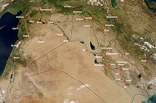
WThe ancient Near East was the home of early civilizations within a region roughly corresponding to the modern Middle East: Mesopotamia, ancient Egypt, ancient Iran, Anatolia/Asia Minor and the Armenian Highlands, the Levant, Cyprus and the Arabian Peninsula. The ancient Near East is studied in the fields of Ancient Near East studies, Near Eastern archaeology and ancient history.
 W
WThe 4.2-kiloyear BP aridification event was one of the most severe climatic events of the Holocene epoch. It defines the beginning of the current Meghalayan age in the Holocene epoch.
 W
WAl-Akhdhar is an archaeological site in Ash Sharqiyah, Oman. It is a cemetery containing with remains dating from the Umm al-Nar, Wadi Suq, Late Iron Age (Samad), and Islamic periods.
 W
WThe Amman Citadel Inscription is the oldest known inscription in the so-called Ammonite language. It was discovered in 1961 in the Amman Citadel, and first published in full in 1968 by Siegfried Horn. The inscription is now in the Jordan Archaeological Museum. At the time of its discovery it was the third longest Semitic stone inscription ever found in the macro-area of Israel / Palestine / Jordan, after the Mesha Stele and the Siloam inscription. The inscription is known as KAI 307.
 W
WAnatolia is a large peninsula in Western Asia and the westernmost protrusion of the Asian continent. It makes up the majority of modern-day Turkey. The region is bounded by the Turkish Straits to the northwest, the Black Sea to the north, the Armenian Highlands to the east, the Mediterranean Sea to the south, and the Aegean Sea to the west. The Sea of Marmara forms a connection between the Black and Aegean seas through the Bosporus and Dardanelles straits and separates Anatolia from Thrace on the Balkan peninsula of Southeast Europe.
 W
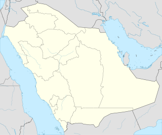
WThirteen ancient towns have been discovered in Saudi Arabia up to the present day. These include Qaryat al-Fāw, the Al-Ukhdūd archeological area, Hegra, Jubbah, Tārūt, Al-Shuwayḥaṭiyah, Thāj, Taimaa and Dūmat Al-Jandal. There are still more ancient towns in Saudi Arabia, but little information is currently available on them. Saudi Arabia occupies a unique and distinctive geographic location, bridging civilizations between continents. In ancient times the Arabian peninsula served as a corridor for trade; therefore it saw the beginning of many civilizations, the relics of which are still evident today. The Saudi government has recently established the Saudi Commission for Tourism and Antiquities, which is responsible for the preservation of these cities.
 W
WAram, also known as Aramea, is the homeland of the Arameans and a historical region mentioned in the Bible, covering much of the present-day Syria, including areas where the cities of Damascus and Aleppo now stand. At its height, Aram stretched from the Mount Lebanon range eastward across the Euphrates, including parts of the Khabur River valley in northwestern Mesopotamia on the border of modern Iraq. During the period from the 10th to the 8th centuries BCE, several Aramean states existed in the region. After the final conquest by the rising Neo-Assyrian Empire in the second half of the 8th century, and also during the later consecutive rules of the Neo-Babylonian Empire and the Achaemenid Empire, region of Aram was also known as Eber-Nari. During the Seleucid period, the term Syria was introduced as Hellenistic designation for this region, but the native name (Aram) persisted in use among Arameans, up to the Arab conquest in the 7th century CE.
 W
WArmani, was an ancient kingdom mentioned by Sargon of Akkad and his grandson Naram-Sin of Akkad as stretching from Ibla to Bit-Nanib; its location is heavily debated, and it continued to be mentioned in later Assyrian inscriptions.
 W
WAssyria, also called the Assyrian Empire, was a Mesopotamian kingdom and empire of the ancient Near East in the area today known as the Levant that existed as a state from perhaps as early as the 25th century BC until its collapse between 612 BC and 609 BC – spanning the periods of the Early to Middle Bronze Age through to the late Iron Age. This vast span of time is divided into the Early Period, Old Assyrian Empire, Middle Assyrian Empire and Neo-Assyrian Empire.
WAssyria, also called the Assyrian Empire, was a Mesopotamian kingdom and empire of the ancient Near East in the area today known as the Levant that existed as a state from perhaps as early as the 25th century BC until its collapse between 612 BC and 609 BC – spanning the periods of the Early to Middle Bronze Age through to the late Iron Age. This vast span of time is divided into the Early Period, Old Assyrian Empire, Middle Assyrian Empire and Neo-Assyrian Empire.
 W
WThe Late Bronze Age collapse was a transition period in the Near East, Anatolia, the Aegean region, North Africa, the Caucasus, the Balkans and the Eastern Mediterranean from the Late Bronze Age to the Early Iron Age, a transition which historians believe was violent, sudden, and culturally disruptive. The palace economy of the Aegean region and Anatolia that characterized the Late Bronze Age disintegrated, transforming into the small isolated village cultures of the Greek Dark Ages.
 W
WThe Carpentras Stele is a stele found at Carpentras in southern France in 1704 that contains the first published inscription written in the Phoenician alphabet. It remains in Carpentras, at the Bibliothèque Inguimbertine, in a "dark corner" on the first floor. It is known as KAI 269 and CIS II 141.
WThe chronology of the ancient Near East is a framework of dates for various events, rulers and dynasties. Historical inscriptions and texts customarily record events in terms of a succession of officials or rulers: "in the year X of king Y". Comparing many records pieces together a relative chronology relating dates in cities over a wide area. For the first millennium BC, the relative chronology can be matched to actual calendar years by identifying significant astronomical events. An inscription from the tenth year of Assyrian king Ashur-Dan III refers to an eclipse of the sun, and astronomical calculations among the range of plausible years date the eclipse to 15 June 763 BC. This can be corroborated by other mentions of astronomical events, and a secure absolute chronology established, tying the relative chronologies to our own calendar.
WThe earliest cities in history were in the ancient Near East, an area covering roughly that of the modern Middle East: its history began in the 4th millennium BC and ended, depending on the interpretation of the term, either with the conquest by the Achaemenid Empire in the 6th century BC or that by Alexander the Great in the 4th century BC.
 W
WA cradle of civilization is a location where civilization is understood to have independently emerged. According to current thinking, there was no single "cradle" of civilization; instead, several cradles of civilization developed independently. The Fertile Crescent and Ancient India are believed to be the earliest. Ancient China emerged somewhat later. The extent to which there was significant influence between the early civilizations of the Near East and those of East Asia is disputed. Scholars accept the fact that the civilizations of Mesoamerica, those that mainly existed in modern-day Mexico, and the civilization in Norte Chico, a region in the north-central coastal region of Peru, emerged independently from those in the Old World.
 W
WElam was an ancient civilization centered in the far west and southwest of modern-day Iran, stretching from the lowlands of what is now Khuzestan and Ilam Province as well as a small part of southern Iraq. The modern name Elam stems from the Sumerian transliteration elam(a), along with the later Akkadian elamtu, and the Elamite haltamti. Elamite states were among the leading political forces of the Ancient Near East. In classical literature, Elam was also known as Susiana, a name derived from its capital Susa.
 W
WThe Fertile Crescent is a crescent-shaped region in the Middle East, spanning modern-day Iraq, Syria, Lebanon, Israel, Palestine, Jordan, Egypt, together with the southeastern region of Turkey and the western fringes of Iran. Some authors also include Cyprus.
 W
WThe prehistory of Georgia is the period between the first human habitation of the territory of modern-day nation of Georgia and the time when Assyrian and Urartian, and more firmly, the Classical accounts, brought the proto-Georgian tribes into the scope of recorded history.
 W
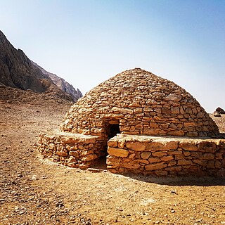
WThe Hafit period defines early Bronze Age human settlement in the United Arab Emirates and Oman in the period from 3200 to 2600 BC. It is named after the distinctive beehive burials first found on Jebel Hafit, a rocky mountain near Al Ain, bordering the Rub Al Khali desert. Hafit period tombs and remains have also been located across the UAE and Oman in sites such as Bidaa bint Saud, Jebel Al-Buhais and Buraimi.
 W
WThe Hittites were an Anatolian people who played an important role in establishing an empire centered on Hattusa in north-central Anatolia around 1680-1650 BCE. This empire reached its height during the mid-14th century BC under Šuppiluliuma I, when it encompassed an area that included most of Anatolia as well as parts of the northern Levant and Upper Mesopotamia.
 W
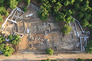
WTel Kabri is an archaeological tell containing one of the largest Middle Bronze Age Canaanite palaces in Israel, and the largest such palace excavated as of 2014. Kabri is named for the abundance of its perennial springs the presence of which has led to the site's occupation and use as a water source from the Pottery Neolithic (PN) period to the present day. Located in the Western Upper Galilee, the site was at the height of its power in the Middle Bronze, controlling much of the surrounding region. Kabri declined as a local power at the end of the Middle Bronze, but the site continued to be occupied at times, on a much reduced level, up until the 1948 Arab-Israeli War.
 W
WThe Levantine corridor is the relatively narrow strip between the Mediterranean Sea to the northwest and deserts to the southeast which connects Africa to Eurasia. This corridor is a land route of migrations of animals between Eurasia and Africa. In particular, it is believed that early hominins spread from Africa to Eurasia via the Levantine corridor and Horn of Africa. The corridor is named after the Levant.
 W
WThe Mannaeans (country name usually Mannea; Akkadian: Mannai, Biblical Hebrew Minni, were an ancient people who lived in the territory of present-day northwestern Iran south of lake Urmia, around the 10th to 7th centuries BC. At that time they were neighbors of the empires of Assyria and Urartu, as well as other small buffer states between the two, such as Musasir and Zikirta.
 W
WThe Marseille Tariff is a Punic language inscription from the third century BCE, found on two fragments of a stone in 1844/45 at Marseille in Southern France. It is thought to have originally come from the temple of Baal-Saphon in Carthage. It is one of the earliest published inscriptions written in the Phoenician alphabet, and one of the longest ever found.
 W
WThe Medes were an ancient Iranian people who spoke the Median language and who inhabited an area known as Media between western and northern Iran. Around the 11th century BC, they occupied the mountainous region of northwestern Iran and the northeastern and eastern region of Mesopotamia located in the region of Hamadan (Ecbatana). Their emergence in Iran is believed to have occurred during the 8th century BC. In the 7th century BC, all of western Iran and some other territories were under Median rule, but their precise geographic extent remains unknown.
 W
WThe Mesha Stele, also known as the Moabite Stone, is a stele dated around 840 BCE containing a significant Canaanite inscription in the name of King Mesha of Moab. Mesha tells how Chemosh, the god of Moab, had been angry with his people and had allowed them to be subjugated to Israel, but at length, Chemosh returned and assisted Mesha to throw off the yoke of Israel and restore the lands of Moab. Mesha describes his many building projects. Some say it is written in the Phoenician alphabet, but others say it is written in the Old Hebrew script, which is closely related.
 W
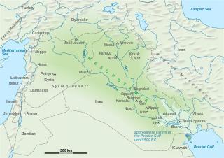
WMesopotamia is a historical region of Western Asia situated within the Tigris–Euphrates river system, in the northern part of the Fertile Crescent. In terms of the modern nation-state it corresponds with much of Iraq, Kuwait, the eastern parts of Syria, Southeastern Turkey, and regions along the Turkish–Syrian and Iran–Iraq borders.
 W
WThe Middle Assyrian Empire is the period in the history of Assyria between the fall of the Old Assyrian Empire in the 14th century BC and the establishment of the Neo-Assyrian Empire in the 10th century BC.
WThe middle chronology is one chronology of the Near Eastern Bronze and Early Iron Age, which fixes the reign of Hammurabi to 1792–1750 BCE and the sack of Babylon to 1595 BCE.
 W
WNear Eastern archaeology is a regional branch of the wider, global discipline of archaeology. It refers generally to the excavation and study of artifacts and material culture of the Near East from antiquity to the recent past.
 W
WThe Neo-Assyrian Empire was an Iron Age Mesopotamian empire, in existence between 911 and 609 BC, and became the largest empire of the world up until that time. The Assyrians perfected early techniques of imperial rule, many of which became standard in later empires. The Assyrians were the first to be armed with iron weapons, and their troops employed advanced, effective military tactics.
 W
WThe Old Assyrian Empire is the second of four periods into which the history of Assyria is divided, the other three being the Early Assyrian Period, the Middle Assyrian Empire, and the Neo-Assyrian Empire. Assyria was a major Mesopotamian East Semitic-speaking kingdom and empire of the ancient Near East. Centered on the Tigris–Euphrates river system in Upper Mesopotamia, the Assyrian people came to rule powerful empires at several times. Making up a substantial part of the "cradle of civilization", which included Sumer, the Akkadian Empire, and Babylonia, Assyria was at the height of technological, scientific and cultural achievements at its peak.
 W
WThe Parthian Empire, also known as the Arsacid Empire, was a major Iranian political and cultural power in ancient Iran. Its latter name comes from its founder, Arsaces I, who led the Parni tribe in conquering the region of Parthia in Iran's northeast, then a satrapy (province) under Andragoras, in rebellion against the Seleucid Empire. Mithridates I (r. c. 171–132 BC) greatly expanded the empire by seizing Media and Mesopotamia from the Seleucids. At its height, the Parthian Empire stretched from the northern reaches of the Euphrates, in what is now central-eastern Turkey, to present-day Afghanistan and western Pakistan. The empire, located on the Silk Road trade route between the Roman Empire in the Mediterranean Basin and the Han dynasty of China, became a center of trade and commerce.
 W
WPhilistia was a confederation of cities in the Southwest Levant. Its appearance follows the invasion of Egypt by the foreign sea People, of which Philistines or Peleset are part, and their alleged relocation to the southern abandoned coast of Canaan by Ramesses III following his victory over them. Philistia northern boundary was the Yarkon River with the Mediterranean Sea on the west, the Kingdom of Judah to the east and the Wadi El-Arish to the south. Philistia consisted of the five city-states of the Philistines, as the Philistine pentapolis, described in the Book of Joshua and the Books of Samuel, comprising Ashkelon, Ashdod, Ekron, Gath, and Gaza, in the south-western Levant.
 W
WPhoenicia was an ancient Semitic-speaking thalassocratic civilization that originated in the Levant region of the eastern Mediterranean, primarily modern Lebanon. It was concentrated along the coast of Lebanon and included some coastal areas of modern Syria and Galilee, reaching as far north as Arwad and as far south as Acre and possibly Gaza. At its height between 1100 and 200 BC, Phoenician civilization spread across the Mediterranean, from the Levant to the Iberian Peninsula.
 W
WThe Pratt Ivories, also known as the Acemhöyük Ivories, are a collection of furniture attachments produced in Anatolia in the early second millennium B.C. They were donated to the Metropolitan Museum of Art between 1932 and 1937 by Mr. and Mrs. George D. Pratt. The group represents one of the most important assemblages of furniture fittings from the ancient Near East. In particular, a preserved set of four sphinxes, three lion legs, a falcon, and two recumbent gazelles, comprise the earliest and most complete evidence for a luxury chair or throne from the ancient world. Many of the other pieces in the group likely belonged to a number of small decorative objects.
 W
WQalaichi, Ghalay-chi, قلایچی in Persian is an important archaeological site for the Iron Age of north-western Iran. It is a mountain 11m high, situated about 9 air km north-west of Bukan City in West Azerbaijan Province 18 km away from the border of Kurdistan province. The site is located near a village from whence it got its name. Hills and mountains surround it; the highest one in the east is the so-called Kal-Tage. Qalaichi is a settlement town in as we know from cuneiform texts which lay in the polity Mannea. The main period of occupation lies from the 9th to 7th centuries BCE. Key archaeological finds include a stele inscribed with an Aramaic text In addition, the ancient settlement yielded a large number of glazed objects. Some of them are monochrome and the others show complex compositions. The glazed objects from the regular excavations curated in Urmia Museum and Tehran National Museum.
 W
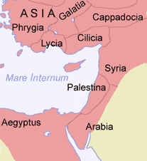
WThe region of Syria, known in modern literature as Greater Syria, "Syria-Palestine", or the Levant, is an area east of the Mediterranean Sea. The region has been controlled by numerous different peoples, including ancient Egyptians, Canaanites, Israelites, Assyria, Babylonia, the Achaemenid Empire, the ancient Macedonians, the Roman Empire, the Byzantine Empire, the Rashidun Caliphate, the Umayyad Caliphate, the Abbasid Caliphate, the Fatimid Caliphate, the Crusaders, the Ayyubid dynasty, the Mamluk Sultanate, the Ottoman Empire, the United Kingdom and the French Third Republic.
 W
WSyria Palaestina was the name given to the Roman province of Judea by the emperor Hadrian following the suppression of the Bar Kokhba revolt in 135 AD.
 W
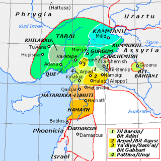
WThe states that are called Syro-Hittite, or Luwian-Aramean, were Luwian and Aramean regional polities of the Iron Age, situated in southeastern parts of modern Turkey and northwestern parts of modern Syria, known in ancient times as lands of Hatti and Aram. They arose following the collapse of the Hittite New Kingdom in the 12th century BCE, and lasted until they were subdued by the Assyrian Empire in the 8th century BCE. They are grouped together by scholars, on the basis of several cultural criteria, that are recognized as similar and mutually shared between both societies, northern (Luwian) and southern (Aramean). Cultural exchange between those societies is seen as a specific regional phenomena, particularly in light of significant linguistic distinctions between two main regional languages, with Luwian belonging to Anatolian group of Indo-European languages, and Aramean belonging to Western Semitic group of Semitic languages. Several questions that are related to regional grouping of Luwian and Aramean states are viewed differently among scholars, including some views that are critical towards such grouping in general.
 W
WThe Tel Siran inscription is an inscription on a bronze bottle found at Tel Siran on the campus of the University of Jordan in Amman). It was first published on 27 April 1972. It is considered the first complete inscription in the "Ammonite language". The bronze bottle is now in the Jordan Archaeological Museum. It is known as KAI 308.
 W
WIn archaeology, a tell or tel, is an artificial topographical feature, a species of mound consisting of the stratified debris from the accumulated refuse of generations of people who once formed a settlement and dwelt on the same site. A classic tell looks like a low, truncated cone with sloping sides and a flat, mesa-like top. They can be more than 43 m (141 ft) high.
 W
WTransjordan is an area of land in the Southern Levant lying east of the Jordan River valley.
 W
WUmm Al Nar is a Bronze Age culture that existed around 2600-2000 BCE in the area of modern-day United Arab Emirates and Northern Oman. The Arabic name has in the past frequently been transliterated as Umm an-Nar and also Umm al-Nar. The etymology derives from the island of the same name which lies adjacent to Abu Dhabi city and which provided early evidence and finds attributed to the period.
 W
WUrartu is a geographical region commonly used as the exonym for the Iron Age kingdom also known by the modern rendition of its endonym, the Kingdom of Van, centered around Lake Van in the historic Armenian Highlands, present-day eastern Anatolia in Turkey. The kingdom rose to power in the mid-9th century BC, but went into gradual decline and was eventually conquered by the Iranian Medes in the early 6th century BC.
 W
WVia Maris is one modern name for an ancient trade route, dating from the early Bronze Age, linking Egypt with the northern empires of Syria, Anatolia and Mesopotamia — along the Mediterranean coast of modern-day Egypt, Palestine, Israel, Iran, Iraq, Turkey and Syria. In Latin, Via Maris means "way of the sea", a translation of the Greek ὁδὸν θαλάσσης found in Isaiah 9:1 of the Septuagint. It is a historic road that runs in part along the Israeli Mediterranean coast. It was the most important route from Egypt to Syria which followed the coastal plain before crossing over into the plain of Jezreel and the Jordan valley.
 W
WThe Wadi Suq culture defines human settlement in the United Arab Emirates and Oman in the period from 2,000 to 1,300 BCE. It takes its name from a wadi, or waterway, west of Sohar in Oman and follows on from the Umm al-Nar culture. Although archaeologists have traditionally tended to view the differences in human settlements and burials between the Umm Al Nar and Wadi Suq periods as the result of major external disruption, contemporary opinion has moved towards a gradual change in human society which is centred around more sophisticated approaches to animal husbandry as well as changes in the surrounding trade and social environments.