 W
WThis is a list of Hopewell sites. The Hopewell tradition refers to the common aspects of the Native American culture that flourished along rivers in the northeastern and midwestern United States from 200 BCE to 500 CE. The Hopewell tradition was not a single culture or society, but a widely dispersed set of related populations that were connected by a common network of trade routes, known as the Hopewell Exchange System.
 W
WThis is a list of Mississippian sites. The Mississippian culture was a mound-building Native American culture that flourished in what is now the Midwestern, inland-Eastern, and Southeastern United States from approximately 800 CE to 1500 CE, varying regionally. Its core area, along the Mississippi River, stretched from sites such as Cahokia in modern Illinois, the largest of all the Mississippian sites, to Mound Bottom in Tennessee, to the Winterville site in the state of Mississippi. Temple mound complexes further extend from Aztalan in Wisconsin to Crystal River in Florida, and from Fort Ancient now in Ohio to Spiro in Oklahoma. Mississippian cultural influences extended as far north and west as modern North Dakota.
 W
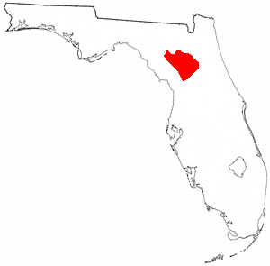
WThe Alachua culture is a Late Woodland Southeast period archaeological culture in north-central Florida, dating from around 600 to 1700. It is found in an area roughly corresponding to present-day Alachua County, the northern half of Marion County and the western part of Putnam County. It was preceded by the Cades Pond culture, which inhabited approximately the same area.
 W
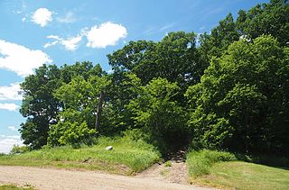
WBarton Village Site, also known as the Herman Barton Indian Village Archeological Site, is a large, multi-component archaeological site near Cumberland in Allegany County, Maryland.
 W
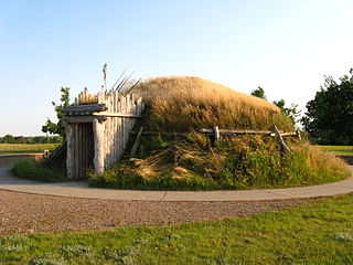
WThe Big Hidatsa site, occupied between ca. 1740 and 1850, is an earthlodge located in the 1,758 acre Knife River Indian Villages National Historic Site in North Dakota, United States. This National Historic Site was established in 1974 “to focus on the cultures and lifestyles of the Plains Indians”, and is a National Park Service Park.
 W
WThe Blood Run Site is an archaeological site on the border of the US states of Iowa and South Dakota. The site was essentially populated for 8,500 years, within which earthworks structures were built by the Oneota Culture and occupied descendant tribes such as the Ioway, Otoe, Missouri, and shared with Quapaw and later Kansa, Osage, and Omaha people. The site was so named on account of the iron-stained soil.
 W
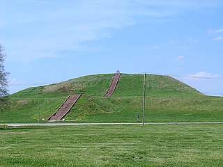
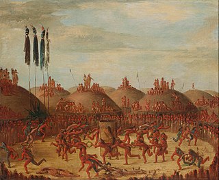
WThe Cahokia Mounds State Historic Site is the site of a pre-Columbian Native American city directly across the Mississippi River from modern St. Louis, Missouri. This historic park lies in south-western Illinois between East St. Louis and Collinsville. The park covers 2,200 acres (890 ha), or about 3.5 square miles (9 km2), and contains about 80 mounds, but the ancient city was much larger. At its apex around 1100 CE, the city covered about 6 square miles (16 km2) and included about 120 manmade earthen mounds in a wide range of sizes, shapes, and functions. At the apex of its population, Cahokia may have briefly exceeded contemporaneous London, which at that time was approximately 14,000–18,000.
 W
WThe Cary Village Site is an archaeological site in the west-central portion of the U.S. state of Ohio. Located southeast of the village of Plain City in Madison County, the site occupies a group of grassy terraces located amid two farm fields. In this grassy area, archaeologists have discovered a wide range of artifacts, including stone tools, materials made of flint, and various types of pottery.
 W
WCasa Malpaís is an archaeological site of the Ancestral Puebloans located near the town of Springerville, Arizona. The site is a nationally recognized archaeological site and was declared a National Historic Landmark in 1964.
 W
WCaughnawaga Indian Village Site is an archaeological site located just west of Fonda in Montgomery County, New York. It is the location of a 17th-century Mohawk nation village. The Mohawk later moved to other areas, and were mostly forced out of New York after the American Revolutionary War.
 W
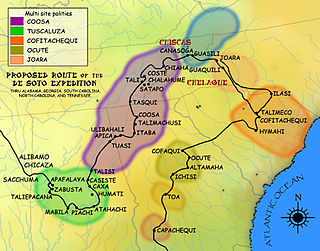
WCofitachequi was a paramount chiefdom founded about 1300 AD and encountered by the Hernando de Soto expedition in South Carolina in April 1540. Cofitachequi was later visited by Juan Pardo during his two expeditions (1566–1568) and by Henry Woodward in 1670. Cofitachequi ceased to exist as a political entity prior to 1701.
 W
WEtzanoa is a historical Wichita city, located in present-day Arkansas City, Kansas, near the Arkansas River, that flourished between 1450 and 1700. Dubbed "the Great Settlement" by Spanish explorers who visited the site, Etzanoa may have housed 20,000 Wichita people. The historical city is considered part of Quivira.
 W
WGreat Hiwassee was an important Overhill Cherokee town from the late 17th through the early 19th centuries. It was located on the Hiwassee River in present-day Polk County, Tennessee, on the north bank of the river where modern U.S. Route 411 crosses the river. The site is now part of the Tennessee Forestry Division's East Tennessee Nursery.
 W
WGreat Tellico was a Cherokee town at the site of present-day Tellico Plains, Tennessee, where the Tellico River emerges from the Appalachian Mountains. Great Tellico was one of the largest Cherokee towns in the region, and had a sister town nearby named Chatuga. Its name in Cherokee is more properly written Talikwa. It is sometimes spelled Telliquo, Telliquah or, in Oklahoma, Tahlequah. There were several Cherokee settlements named Tellico, the largest of which is distinguished from the others by calling it "Great". The meaning of the word "Talikwa" is thought to be lost by the Cherokees. However, in an article authored by reporter Tesina Jackson of the Cherokee Phoenix the meaning of the word is stated as "the open place where the grass grows".
 W
WThe Hohokam Pima National Monument is an ancient Hohokam village within the Gila River Indian Community, near present-day Sacaton, Arizona. The monument features the archaeological site Snaketown 30 miles (48 km) southeast of Phoenix, Arizona, designated a National Historic Landmark in 1964. The area was further protected by declaring it a National Monument in 1972, and was listed on the National Register of Historic Places in 1974.
 W
WThe Iliniwek Village State Historic Site is a state-owned property in Clark County, Missouri, maintained by the Missouri Department of Natural Resources, preserving the only known Illinois Indian village discovered in Missouri.
 W
WIndian Old Fields was an unincorporated community located in Clark County, Kentucky, United States.
 W
WIndian removals in Indiana followed a series of the land cession treaties made between 1795 and 1846 that led to the removal of most of the native tribes from Indiana. Some of the removals occurred prior to 1830, but most took place between 1830 and 1846. The Lenape (Delaware), Piankashaw, Kickapoo, Wea, and Shawnee were removed in the 1820s and 1830s, but the Potawatomi and Miami removals in the 1830s and 1840s were more gradual and incomplete, and not all of Indiana's Native Americans voluntarily left the state. The most well-known resistance effort in Indiana was the forced removal of Chief Menominee and his Yellow River band of Potawatomi in what became known as the Potawatomi Trail of Death in 1838, in which 859 Potawatomi were removed to Kansas and at least forty died on the journey west. The Miami were the last to be removed from Indiana, but tribal leaders delayed the process until 1846. Many of the Miami were permitted to remain on land allotments guaranteed to them under the Treaty of St. Mary's (1818) and subsequent treaties.
 W
WThe archaeology of Iowa is the study of the buried remains of human culture within the U.S. state of Iowa from the earliest prehistoric through the late historic periods. When the American Indians first arrived in what is now Iowa more than 13,000 years ago, they were hunters and gatherers living in a Pleistocene glacial landscape. By the time European explorers visited Iowa, American Indians were largely settled farmers with complex economic, social, and political systems. This transformation happened gradually. During the Archaic period American Indians adapted to local environments and ecosystems, slowly becoming more sedentary as populations increased. More than 3,000 years ago, during the Late Archaic period, American Indians in Iowa began utilizing domesticated plants. The subsequent Woodland period saw an increase on the reliance on agriculture and social complexity, with increased use of mounds, ceramics, and specialized subsistence. During the Late Prehistoric period increased use of maize and social changes led to social flourishing and nucleated settlements. The arrival of European trade goods and diseases in the Protohistoric period led to dramatic population shifts and economic and social upheaval, with the arrival of new tribes and early European explorers and traders. During the Historical period European traders and American Indians in Iowa gave way to American settlers and Iowa was transformed into an agricultural state.
 W
WKanadaseaga, was a major village, perhaps a capital, of the Seneca nation of the Iroquois Confederacy in west-central New York State, United States. It was located between the northern ends of Seneca and Canandaigua lakes, one and a half miles northwest of the present-day city of Geneva in the township of Seneca. The village was situated on both sides of Kanadaseaga Creek. The Seneca established this village at least as early as 1687. It was likely established by the former residents of Ganondagan, after its destruction by the French.
 W
WKittanning was an 18th-century Native American village in the Ohio Country, located on the Allegheny River at present-day Kittanning, Pennsylvania. The village was at the western terminus of the Kittanning Path, an Indian trail that provided a route across the Alleghenies between the Ohio and Susquehanna river basins. The village, inhabited by Delaware (Lenape) and Shawnee Indians, was most likely the largest such village on the western side of the Alleghenies at the time, having an estimated 300–400 residents in 1756. Kittanning was settled in 1724 by Indians who had migrated from eastern Pennsylvania as white settlement rapidly expanded.
 W
WThe Knife River Indian Villages National Historic Site, which was established in 1974, preserves the historic and archaeological remnants of bands of Hidatsa, Northern Plains Indians, in North Dakota. This area was a major trading and agricultural area. Three villages were known to occupy the Knife area. In general, these three villages are known as Hidatsa villages. Broken down, the individual villages are Awatixa Xi'e, Awatixa and Big Hidatsa village. Awatixa Xi'e is believed to be the oldest village of the three. The Big Hidatsa village was established around 1600.
 W
WThe Kolmer Site is an archaeological site in the far southwest of the U.S. state of Illinois. Located near Kaskaskia and Prairie du Rocher in western Randolph County, it lies at the site of an early historic Indian village from the French period. Because it occupies a critical chronological and cultural position, it has been given national recognition as a historic site.
 W
WThe Manasota culture was an archaeological culture that was practiced on the central Gulf coast of the Florida peninsula from about 500 BCE until about 900, when it developed into the Safety Harbor culture. From about 300 to 700 the Manasota culture adopted the ceremonial ceramics and burial practices of the Weeden Island cultures of northern Florida and adjacent Alabama and Georgia.
 W
WThe Mayberry Mound and Village Site are a valuable archaeological site in the southeastern portion of the U.S. state of Illinois. Located near the village of Sims in southern Wayne County, the site comprises what was once a substantial village during the Archaic period, and it has been designated a historic site because of its archaeological importance.
 W
WMitutanka (Matootonah) was the lower Mandan village at the time of the Lewis and Clark expedition. At the time that Lewis and Clark visited the main chief was Sheheke
 W
WMohawk Upper Castle Historic District is a historic district in Herkimer County, New York that was declared a National Historic Landmark in 1993. Located south of the Mohawk River, it includes the Indian Castle Church, built in 1769 by Sir William Johnson, British Superintendent of Indian Affairs, as a missionary church for the Mohawk in the western part of their territory; the Brant Family Barn, a rare surviving example of Dutch colonial barns in the Mohawk Valley; as well as important archaeological site areas revealing life in Nowadaga, as the western part of the Mohawk village of Canajoharie was known. The fortified village was called the Upper Castle by European colonists.
 W
WThe Mountain Lake Site is an archaeological site in Mountain Lake Township, Minnesota, United States. It is a deeply stratified village site spanning the precontact era from the late Archaic to an Oneota occupation, with a particular concentration of Woodland period ceramics. The site is atop a hill that was formerly an island in a lake. The site was listed on the National Register of Historic Places in 1977 for its state significance in the theme of archaeology.
WOcute, later known as Altamaha or La Tama and sometimes known conventionally as the Oconee province, was a Native American paramount chiefdom in the Piedmont region of the U.S. state of Georgia in the 16th and 17th centuries. Centered in the Oconee River valley, the main chiefdom of Ocute held sway over the nearby chiefdoms of Altamaha, Cofaqui, and possibly others.
 W
WThe Pequot Fort was a fortified Native American village in what is now the Groton side of Mystic, Connecticut. Located atop a ridge overlooking the Mystic River, it was a palisaded settlement of the Pequot tribe until its destruction by English colonial and Native American forces in the 1637 Mystic massacre. The exact location of its archaeological remains is not certain, but it is commemorated by a small memorial at Pequot Avenue and Clift Street. The site previously included a statue of Major John Mason, who led the forces that destroyed the fort; it was somewhat controversially removed in 1995 after protests by Pequot tribal members. The archaeological site was added to the National Register of Historic Places in 1990.
 W
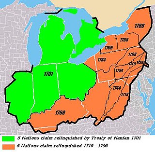
WThe Six Nations land cessions were a series of land cessions by the Iroquois "Six Nations" and Delaware Indians in the late 17th and 18th centuries in which the natives ceded nearly all of their vast conquered lands as well as ancestral land within and adjacent to the northern British colonies of North America. The land cessions covered most or all of the modern states of New York, Pennsylvania, western Maryland, Virginia and West Virginia, Kentucky, northeastern Ohio and extended marginally into northern Tennessee and North Carolina. The lands were bordered to the west by the Algonquin tribal lands of Ohio Country, Cherokee lands to the south, and Creek and other southeastern tribal lands to the southeast.
 W
WSundown Mounds is an multimound archaeological site in Tensas Parish, Louisiana from the Early Coles Creek culture. It is the type site for the Sundown Phase of the Tensas Basin and Natchez Bluff Coles Creek chronology.
 W
WTotiakton was a town of the Seneca Nation located in the present-day town of Mendon, New York. It is located "on the northernmost bend of Honeoye outlet" two miles from the current village of Honeoye Falls. The Seneca name for the town was De-yu-di-haak-doh, meaning “the bend," because of its location at a bend of Honeoye Creek. The archaeological remains of the site are listed on the National Register of Historic Places.
 W
WThe Native American settlement of Turkeytown, sometimes called "Turkey's Town", was named after the original founder of the settlement, the Chickamauga Cherokee chief, Little Turkey. At one point in history, this seemingly inconspicuous village stretched for approximately 25 miles along both banks of the Coosa River, and became the largest of the contemporary Cherokee towns.
 W
WTuskegee was an Overhill Cherokee town located along the Little Tennessee River in what is now Monroe County, Tennessee, United States. The town developed in the late 1750s alongside Fort Loudoun, and was inhabited until the late 1770s. It was forcibly evacuated and probably burned during the Cherokee–American wars.