 W
WThe Algoman orogeny, known as the Kenoran orogeny in Canada, was an episode of mountain-building (orogeny) during the Late Archean Eon that involved repeated episodes of continental collisions, compressions and subductions. The Superior province and the Minnesota River Valley terrane collided about 2,700 to 2,500 million years ago. The collision folded the Earth's crust and produced enough heat and pressure to metamorphose the rock. Blocks were added to the Superior province along a 1,200 km (750 mi) boundary that stretches from present-day eastern South Dakota into the Lake Huron area. The Algoman orogeny brought the Archaen Eon to a close, about 2,500 million years ago; it lasted less than 100 million years and marks a major change in the development of the Earth's crust.
 W
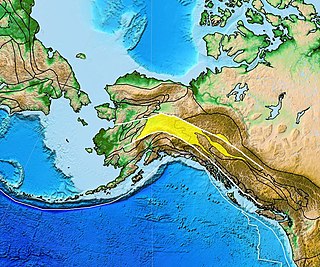
WThe Arctic Alaska-Chukotka terrane (AAC) is a microcontinent that today encompasses the North Slope, Brooks Range, and Seward Peninsula of northern Alaska; the Chukotka Peninsula, New Siberia Islands, and Wrangel Island in eastern Siberia; and the continental shelves of the Bering, Beaufort, and Chukchi seas. Comparable in size to Greenland, the AAC is the largest of the Neoproterozoic–early Paleozoic continental fragments now dispersed around the Arctic Ocean; some of which possibly formed the continent Arctida.
 W
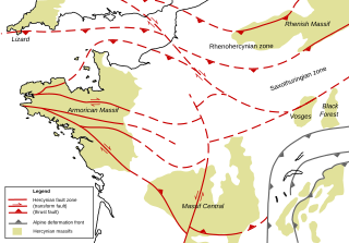
WThe Armorican Massif is a geologic massif that covers a large area in the northwest of France, including Brittany, the western part of Normandy and the Pays de la Loire. It is important because it is connected to Dover on the British side of the English Channel and there has been tilting back and forth that has controlled the geography on both sides.
 W
WThe Armorican terrane, Armorican terrane assemblage, or simply Armorica, was a microcontinent or group of continental fragments that rifted away from Gondwana towards the end of the Silurian and collided with Laurussia towards the end of the Carboniferous during the Variscan orogeny. The name is taken from Armorica, the Gaulish name for a large part of northwestern France that includes Brittany, as this matches closely to the present location of the rock units that form the main part of this terrane.
 W
WAvalonia was a microcontinent in the Paleozoic era. Crustal fragments of this former microcontinent underlie south-west Great Britain, southern Ireland, and the eastern coast of North America. It is the source of many of the older rocks of Western Europe, Atlantic Canada, and parts of the coastal United States. Avalonia is named for the Avalon Peninsula in Newfoundland.
 W
WThe Briançonnais zone or Briançonnais terrane is a piece of continental crust found in the Penninic nappes of the Alps.
 W
WThe Caribbean Terrane is one of the geological provinces (terranes) of Colombia. The terrane, dating to the Late Cretaceous, is situated on the North Andes Plate and borders the La Guajira, Chibcha and underlying Tahamí Terrane along the regional Bucaramanga-Santa Marta Fault. The terrane overlies the Tahamí, Arquía and Quebradagrande Terranes along the Romeral Fault System.
WThe Chibcha Terrane, named after Chibcha, is the largest of the geological provinces (terranes) of Colombia. The terrane, the oldest explored domains of which date to the Meso- to Neoproterozoic, is situated on the North Andes Plate. The megaregional Romeral Fault System forms the contact of the terrane with the Tahamí Terrane. The contact with the Caribbean and La Guajira Terranes is formed by the regional Bucaramanga-Santa Marta Fault. The northeastern boundary is formed by the regional Oca Fault, bounding the La Guajira Terrane. The terrane is emplaced over the Río Negro-Juruena Province of the Amazonian Craton along the megaregional Eastern Frontal Fault System.
 W
WThe Dun Mountain-Maitai Terrane comprises the Dun Mountain Ophiolite Belt, Maitai Group and Patuki Mélange. The Dun Mountain Ophiolite is an ophiolite of Permian age located in New Zealand's South Island. Prehistorically this ophiolite was quarried by Māori for both metasomatized argillite and pounamu (jade) which was used in the production of tools and jewellery.
 W
WThe Florida Platform is a flat geological feature with the emergent portion forming the Florida peninsula.
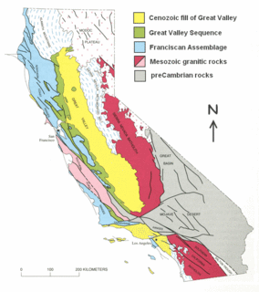
The Franciscan Complex or Franciscan Assemblage is a geologic term for a late Mesozoic terrane of heterogeneous rocks found throughout the California Coast Ranges, and particularly on the San Francisco Peninsula. It was named by geologist Andrew Lawson, who also named the San Andreas fault that defines the western extent of the assemblage.
 W
WThe Gascoyne Complex is a terrane of Proterozoic granite and metamorphic rock in the central-western part of Western Australia. The complex outcrops at the exposed western end of the Capricorn Orogen, a 1,000 km-long arcuate belt of folded, faulted and metamorphosed rocks between two Archean cratons; the Pilbara craton to the north and the Yilgarn craton to the south. The Gascoyne Complex is thought to record the collision of these two different Archean continental fragments during the Capricorn Orogeny at 1830–1780 Ma.
 W
WThe Great Valley Sequence of California is a 40,000-foot (12 km)-thick group of related geologic formations that are Late Jurassic through Cretaceous in age on the geologic time scale. These sedimentary rocks were deposited during the late Mesozoic Era in an ancient seaway that corresponds roughly to the outline of the modern Great Valley of California.
 W
WThe Hebridean Terrane is one of the terranes that form part of the Caledonian orogenic belt in northwest Scotland. Its boundary with the neighbouring Northern Highland Terrane is formed by the Moine Thrust Belt. The basement is formed by Archaean and Paleoproterozoic gneisses of the Lewisian complex, unconformably overlain by the Neoproterozoic Torridonian sediments, which in turn are unconformably overlain by a sequence of Cambro–Ordovician sediments. It formed part of the Laurentian foreland during the Caledonian continental collision.
WThe Ivrea zone is a tectonic terrane in the Italian Alps, that consists of a steeply dipping piece of the Earth’s lower crust of the Apulian plate. The zone is named after the Italian city of Ivrea.
WLa Guajira Terrane is one of the geological provinces (terranes) of Colombia. The terrane, dating to the Late Cretaceous, is situated on the North Andes Plate and borders the Caribbean, Tahamí and Chibcha Terranes along the Bucaramanga-Santa Marta Fault. The southern boundary is formed by the Oca Fault with the Chibcha Terrane.
 W
WThe Lhasa terrane is a terrane, or fragment of crustal material, sutured to the Eurasian Plate during the Cretaceous that forms present-day southern Tibet. It takes its name from the city of Lhasa in the Tibet Autonomous Region, China. The northern part may have originated in the East African Orogeny, while the southern part appears to have once been part of Australia. The two parts joined, were later attached to Asia, and then were impacted by the collision of the Indian Plate that formed the Himalayas.
 W
WThe Meguma terrane, also known as Megumia, is a terrane exposed in southern Nova Scotia, that became joined to the present North American landmass as part of the Appalachian orogeny.
 W
WThe Narryer Gneiss Terrane is a geological complex in Western Australia that is composed of a tectonically interleaved and polydeformed mixture of granite, mafic intrusions and metasedimentary rocks in excess of 3.3 billion years old, with the majority of the Narryer Gneiss Terrane in excess of 3.6 billion years old. The rocks have experienced multiple metamorphic events at amphibolite or granulite conditions, resulting in often complete destruction of original igneous or sedimentary (protolith) textures. Importantly, it contains the oldest known samples of the Earth's crust: samples of zircon from the Jack Hills portion of the Narryer Gneiss have been radiometrically dated at 4.4 billion years old, although the majority of zircon crystals are about 3.6-3.8 billion years old.
 W
WThe Omineca Arc or Omineca Belt was a Jurassic through Cretaceous volcanic arc terrane in western North America, extending from Alaska through Yukon and British Columbia to Washington. The Omineca is bounded by the Foreland Belt to the east and the Intermontane Belt to the west. It is named after the Omineca Mountains of north-central British Columbia.
 W
WPelso Plate or Pelsonia Terrane is a small tectonic unit. It is situated in the Pannonian Basin in Europe. The Carpathian Mountains and the basin surrounded by them were formed from the Cretaceous until the Miocene in the collision of continental Europe with smaller continental fragments of ALCAPA, Tisza, Pelso and Dacia microplates. The Zagreb-Hernád line is the former plate margin between the Pelso of African origin and the Tisza Plate of Eurasian origin.
 W
WThe Qiantang terrane is one of three main west-east-trending terranes of the Tibetan Plateau.
 W
WThe Salinian Block or Salinian terrane is a geologic terrane which lies west of the main trace of the San Andreas Fault system in California. It is bounded on the south by the Big Pine Fault in Ventura County and on the west by the Nacimiento Fault. It was named for the Salinas Valley in Monterey County, California.
 W
WThe Sonoma Volcanics are a geologic formation of volcanic origin that is widespread in Napa and Sonoma counties, California. Most of the formation is Pliocene in age and includes obsidian, perlitic glass, diatomaceous mud, pyroclastic tuff, pumice, rhyolite tuffs, andesite breccias and interbedded volcanic (basalt) lava flows. The formation serves as the parent material for many of the soils in the Napa and Sonoma wine regions.
 W
WStikinia, or the Stikine terrane, is a terrane in British Columbia, Canada; the largest of the Canadian Cordillera. It formed as an independent, intraoceanic volcanic arc during the Paleozoic and Mesozoic.
WThe Tahamí or Tahamí-Panzenú Terrane is one of the geological provinces (terranes) of Colombia. The terrane, dating to the Permo-Triassic, is situated on the North Andes Plate. The contact with the Chibcha, Arquía and Quebradagrande Terranes is formed by the megaregional Romeral Fault System. A tiny terrane is located at the contact with the Quebradagrande Terrane; Anacona Terrane.
 W
WThe Takaka Terrane is a Paleozoic terrane that outcrops in the South Island of New Zealand. It is most extensively exposed within the Kahurangi National Park in the Tasman District. The terrane is mostly made up of marble and volcanic rocks but is highly variable in composition. It ranges in age from mid-Cambrian to Devonian time, including New Zealand's oldest rocks, which are found in the Cobb Valley in north-west Nelson. The Cobb Valley is also the location of "Trilobite Rock" a glacial dropstone made from the moulted exoskeletons of trilobites. Asbestos was mined in the Cobb Valley from the Takaka Terrene between the late 1880s and 1917. The Takaka Terrane is highly deformed and has been intruded by many batholiths.
 W
WThe Torlesse Composite Terrane is a plate tectonic terrane forming part of the South Island of New Zealand. It contains the Rakaia, Aspiring and Pahau Terranes and the Esk Head Belt. Greywacke is the dominant rock type of the composite terrane; argillite is less common and there are minor basalt occurrences. The Torlesse Composite Terrane is found east of the Alpine Fault in the Southern Alps of New Zealand. Its southern extent is a cryptic boundary with the Caples Terrane within the Haast Schists in Central Otago. It is named for the Torlesse Range in Canterbury.
 W
WThe Tuareg Shield is a geological formation lying between the West African craton and the Saharan Metacraton in West Africa. Named after the Tuareg people, it has complex a geology, reflecting the collision between these cratons and later events. The landmass covers parts of Algeria, Niger and Mali.
 W
WThe Wrangellia Terrane is a terrane extending from the south-central part of Alaska through southwestern Yukon and along the Coast of British Columbia in Canada. Some geologists contend that Wrangellia extends southward to Oregon, although this is not generally accepted.
 W
WThe Wrekin Terrane is one of five inferred fault bounded terranes that make up the basement rocks of the southern United Kingdom. The other notable geological terranes in the region are the Charnwood Terrane, Fenland Terrane, Cymru Terrane and the Monian Composite Terrane. The Wrekin Terrane is bounded to the west by the Welsh Borderland Fault System and to the east by the Malvern Lineament. The geological terrane to the west is the Cymru Terrane and to the east is Charnwood Terrane. The majority of rocks in the area are associated with the outcrops that are evident at the faulted boundaries.
 W
WThe Yukon–Tanana Terrane (YTT) is a tectonic terrane that extends from central Alaska through central Yukon and into northern British Columbia, Canada and Southeast Alaska, USA. Extending over 2000 km, the YTT is the largest tectonostratigraphic terrane in the northern North American Cordillera. The Yukon–Tanana Upland is a physiographic province mostly underlain by rocks of the Yukon–Tanana Terrane.