 W
WAchna is an abandoned village in the Famagusta District of Cyprus. It is just north of the Buffer Zone and it is under the de facto control of Northern Cyprus. After the 1974 Turkish invasion, its displaced inhabitants built a new village nearby.
 W
WAetokremnos is a rock shelter near Limassol on the southern coast of Cyprus. It is situated on a steep cliff site c. 40 m (131.23 ft) above the Mediterranean sea. The name means "Cliff of the eagles" in Greek. Around 40 m2 (430.56 sq ft) have been excavated and out of the four layers documented, the third is sterile.
WAgios Georgios Soleas is an abandoned village due to the turkish invasion in Cyprus in 1974 in the Nicosia District of Cyprus, and it lies within the UN Buffer Zone. In 1960, the village had a population of 460; 312 identifying themselves as Greeks, 143 identifying themselves as Turks, and the other 5 not indicating an ethnicity or of mixed heritage. The population declined to zero by 1980 due to the placement of the Buffer Zone and the village was still abandoned at the time of the 2001 census.
WAgios Ioannis Selemani is a deserted village in the Nicosia District of Cyprus, located within the UN Buffer Zone close to Kato Pyrgos.
WAgios Nikolaos Lefkas is an abandoned village in the Nicosia District of Cyprus, and it lies within the UN Buffer Zone. In 1946, the village had a population of 132. This declined to 67 by the time of the 1960 census and the village was abandoned altogether with the creation of the UN Buffer Zone.
 W
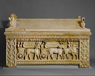
WAmathus or Amathous was an ancient city and one of the ancient royal cities of Cyprus until about 300 BC. Some of its impressive remains can be seen today on the southern coast in front of Agios Tychonas, about 24 miles (39 km) west of Larnaca and 6 miles (9.7 km) east of Limassol. Its ancient cult sanctuary of Aphrodite was the second most important in Cyprus, her homeland, after Paphos.
 W
WArtemi is a small village in the Famagusta District of Cyprus, located 9 km north of Lefkoniko on the south side of the Kyrenia mountain range. It is under the de facto control of Northern Cyprus.
 W
WChytri was one of the ten city-kingdoms of Cyprus in antiquity. It was beautifully located in the centre of the island, in the territory of Chytraea, west of Mesaoria. Today the modern town of Kythrea (Kyrka) has preserved the ancient name.
WDyo Potamoi is an abandoned hamlet in Cyprus, east of Kapouti. De facto, it is under the control of Northern Cyprus.
 W
WGalini is a deserted village in Cyprus, 8 kilometres (5.0 mi) north-west of Lefka in the Morphou Bay area. It is under the de facto control of Northern Cyprus.
 W
WIdalion or Idalium was an ancient city in Cyprus, in modern Dali, Nicosia District. The city was founded on the copper trade in the 3rd millennium BC. Its name in the 8th century BC was "Ed-di-al" as it appears on the Sargon Stele of 707 BC, and a little later on the nl:Prism of Esarhaddon.
 W
WKarpasia, Latinized as Carpasia, and also known as Karpasion, was an ancient town in Cyprus, situated in the northern shore of the Karpas Peninsula, at a distance of 3 km from the modern town of Rizokarpaso. According to tradition, it was founded by the Phoenician King Pygmalion of Tyre. It had a harbour, whose moles remain visible to this day.
 W
WKhirokitia is an archaeological site on the island of Cyprus dating from the Neolithic age. It has been listed as a World Heritage Site by UNESCO since 1998. The site is known as one of the most important and best preserved prehistoric sites of the eastern Mediterranean. Much of its importance lies in the evidence of an organised functional society in the form of a collective settlement, with surrounding fortifications for communal protection. The Neolithic aceramic period is represented by this settlement and around 20 other similar settlements spread throughout the island.
 W
WKition, also known by its Latin name Citium, was a city-kingdom on the southern coast of Cyprus. It was established in the 13th century BC by the Greek (Achaean) settlers, after the Trojan war. According to the text on the plaque closest to the excavation pit of the Kathari site.
 W
WKokkina is a coastal exclave (pene-exclave) of the de facto Northern Cyprus, and a former Turkish Cypriot village and enclave in Cyprus. It is surrounded by mountainous territory, with the Morphou Bay on its northern flank. Kokkina sits several kilometres west of the Northern Cyprus mainland and is a place with symbolic significance to Turkish Cypriots, because of the events of August 1964. In 1976, all Kokkina inhabitants were transferred to Gialousa and the exclave has since functioned as a North Cyprus Defence Force military camp.
 W
WKourion or Latin: Curium, was an important ancient city-state on the southwestern coast of Cyprus. In the twelfth century BCE, after the collapse of the Mycenaean palaces, Greek settlers from Argos arrived on this site.
WLapathus, also recorded as Lapethus, Lepethis, and Lapithus, was an ancient Cypriot town near present-day Lampousa and Karavas.
WLedra, also spelt Ledrae was an ancient city-kingdom located in the centre of Cyprus where the capital city of Nicosia is today.
WMarion was one of the Ten city-kingdoms of Cyprus. It was situated in the north-west of the island in the Akamas region, close to or under the present town of Polis. Both Strabo and Pliny the Elder mention the city in their writings.
WPetra is a former village in Cyprus, now uninhabited and largely destroyed. It is located east of the town of Lefka and just north the Green Line. De facto, Petra is under the control of Northern Cyprus.
WPetrofani is an abandoned village in central Cyprus. It is located in the Larnaca District and is about 2.5 kilometers southwest of Athienou. Petrofani is close to the United Nations Buffer Zone in Cyprus. Prior to the 1974 Turkish invasion of Cyprus, the village was inhabited by Turkish Cypriots.
 W
WPyla-Kokkinokremos was a Late Bronze Age settlement on Cyprus, abandoned after a brief occupation.
WPyrogi is a village in the Nicosia District of Cyprus, located south of Tymvou. It is under de facto control of Northern Cyprus. Today it is largely uninhabited, as the village lies within military area and can only be visited with permission of the Turkish military. In 1960 the village had 460 inhabitants. One kilometre northwest of the town lies the also uninhabited former village of Margo.
 W
WSalamis is an ancient Greek city-state on the east coast of Cyprus, at the mouth of the river Pedieos, 6 km north of modern Famagusta. According to tradition, the founder of Salamis was Teucer, son of Telamon, who could not return home after the Trojan war because he had failed to avenge his brother Ajax.
WSarama is a deserted Turkish Cypriot village in the Paphos District of Cyprus, located 7 km south of Lysos. The village was devastated by an earthquake, which appears to be the reason it was deserted, although an insect destructive to the corn crop was reported to be affecting farmers of the village in 1879. Thermal springs in the vicinity indicate powerful hydrothermal activity.
WSoli or Soloi is an ancient Greek city in the island of Cyprus, located southwest of Morphou (Guzelyurt), and on the coast in the gulf of Morphou and dates back to about the 6th century BC. Since 1974 the city has lain in the de facto Turkish Republic of Northern Cyprus.
WTamassos or Tamasos – names Latinized as Tamassus or Tamasus – was a city-kingdom in Cyprus, one of the 10 Kingdoms of Cyprus. It was situated in the great central plain of the island, south-east of Soli, on the road from Soli to Tremithus. It is an archaeological site bordering the village of Politiko, about 21 kilometres southwest of Nicosia.
 W
WTenta, also known as Kalavasos-Tenta or Tenda, is a neolithic settlement in Cyprus, 4 km south of Kalavasos in the Larnaca District. It was discovered in 1947 by Porphyrios Dikaios.
WVarosha is an abandoned southern quarter of the Cypriot city of Famagusta. Before 1974, it was the modern tourist area of the city. Its inhabitants fled during the Turkish invasion of Cyprus in 1974, when the city of Famagusta came under Turkish control, and it has remained abandoned ever since. As of 2019, the quarter continues to be uninhabited; buildings have decayed, and, in some cases, their contents have been looted over the years; some streets have been overgrown with vegetation; and the quarter is generally described as a ghost town. Entry is forbidden to the public.