 W
WFew Jews arrived in Baltimore, Maryland, in its early years. As an immigrant port of entry and border town between North and South and as a manufacturing center in its own right, Baltimore has been well-positioned to reflect developments in American Jewish life. Yet, the Jewish community of Baltimore has maintained its own distinctive character as well.
 W
WBoyle Heights, historically known as Paredón Blanco, is a neighborhood located in the region east of the Los Angeles River with almost 100,000 residents in Los Angeles, California.
 W
WButchers Hill is a neighborhood in Southeast Baltimore, Maryland, United States. It is north of Fells Point, east of Washington Hill, and northwest of Patterson Park. It is south of Fayette Street, west of Patterson Park Avenue, north of Pratt Street, and east of Washington Street. It is in the 21231 zip code.
 W
WThe Central Area, commonly called the Central District or CD, is a mostly residential district in Seattle located east of downtown and First Hill ; west of Madrona, Leschi and Mt. Baker; south of Capitol Hill, and north of Rainier Valley. Historically, the Central District has been one of Seattle's most racially and ethnically diverse neighborhoods, and was once the center of Seattle's black community and a major hub of African-American businesses.
 W
WChelsea is a city in Suffolk County, Massachusetts, United States, directly across the Mystic River from the city of Boston. As of the 2010 census, Chelsea had a population of 35,177. It is also the second most densely populated city in Massachusetts behind Somerville. With a total area of just 2.21 square miles, Chelsea is the smallest city in Massachusetts in terms of total area.
 W
WCongregation B'nai Israel is the oldest Jewish congregation in Sacramento, California. The congregation, which began as an Orthodox community, traces its history back to the California Gold Rush of 1849, when Jewish settlers gathered to observe the High Holy days. The congregation purchased its first building at 7th and L streets on September 2, 1852, making it the first congregationally owned synagogue west of the Mississippi River.
 W
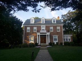
WDumbarton Historic District is a national historic district in Pikesville, Baltimore County, Maryland, United States. The suburban subdivision features curvilinear streets, generously sized lots, and naturalistic landscaping that generally reflect design principles associated with Frederick Law Olmsted. These features characterized the Roland Park Company's seminal developments. Many of subdivision's original residents were prominent Jewish merchants and industrialists, most of whom were of German descent.
 W
WEutaw Street is a major street in Baltimore, Maryland, mostly within the downtown area. Outside of downtown, it is mostly known as Eutaw Place.
 W
WForest Hills is a residential neighborhood in the northwest quadrant of Washington, D.C., United States, bounded by Connecticut Avenue NW to the west, Rock Creek Park to the east, Chevy Chase to the north, and Tilden Street NW to the south. The neighborhood is frequently referred to as Van Ness, both because of its proximity to the University of the District of Columbia (UDC)'s Van Ness campus, and because it is served by the Van Ness–UDC station on the Washington Metro's Red Line.
 W
WForest Park is a region of Northwest Baltimore, Maryland located west of Reisterstown Road, south of Northern Parkway, and east of the Baltimore City/County line. In Baltimore, the region is referred to by locals simply as "Forest Park" and includes the neighborhoods of Ashburton, Callaway-Garrison, Central Forest Park, Dolfield, Dorchester, East Arlington, Forest Park, Grove Park, Hanlon Longwood, Howard Park, Garwyn Oaks, Purnell, West Arlington, West Forest Park, and Windsor Hills.
 W
WFranklin Knolls is a residential neighborhood located in Silver Spring, a census-designated place in Montgomery County.
 W
WJews have inhabited the city of Galveston, Texas, for almost two centuries. The first known Jewish immigrant to the Galveston area was Jao de la Porta, who, along with his brother Morin, financed the first settlement by Europeans on Galveston Island in 1816. de la Porta was born in Portugal of Jewish parentage and later became a Jewish Texan trader. In 1818, Jean Laffite appointed de la Porta supercargo for the Karankawa Indian trade. When Laffite left Galveston Island in 1820, de la Porta became a full-time trader.
 W
WGlenville is a neighborhood on the east side of Cleveland, Ohio. The neighborhood has an irregular border. It begins in the northeast at Eddy Road, and follows Hazeldell Road, E. 110th Street, and Lakeview Road south to E. 114th Street. It follows E. 114th Street South to Superior Avenue, where the border moves east to E. 125th Street. It follows E. 125th Street south to Hower Avenue, and then cuts across residential blocks in a due-south line to Wade Park Avenue. It roughly follows Wade Park Avenue west to E. 105th Street, then E. 105th Street north to Superior Avenue. It follows Superior Avenue west to E. 98th Street. The border follows Parkgate Avenue west, cuts across Rockefeller Park to Crumb Avenue, and then follows Crumb Avenue, E. 79th Street, and St. Clair Avenue to E. 72nd Street. After following E. 72nd Street north to the Lake Erie shore, it follows the shore to encompass the Cleveland Lakefront Nature Preserve before moving due south inland to the Cleveland Memorial Shoreway. The border then follows the Shoreway to Eddy Road.
 W
WThe Jewish community of Houston, Texas has grown and thrived since the 1800s. As of 2008 Jews lived in many Houston neighborhoods and Meyerland is the center of the Jewish community in the area.
 W
WIsland of Roses: The Jews of Rhodes in Los Angeles is a 1995 documentary about the dying Sephardic community in Los Angeles. The film shares interviews with some of the last surviving immigrants, who offer nostalgic memories of their lost home, and explores how the once vibrant community of Rhodes Jews in Los Angeles now struggles to preserve its traditions as younger, assimilated generations have to make a conscious effort to maintain the practices of their ancestors.
 W
WJonestown is a neighborhood in the southeastern district of Baltimore. Its boundaries are the north side of Pratt Street, the west side of Central Avenue, the east side of Fallsway, and the south side of Orleans Street. The neighborhood lies north of the Little Italy, south of the Old Town, west of the Washington Hill, and east of the Downtown Baltimore neighborhoods. The southern terminus of the Jones Falls Expressway is located here.
 W
WLangley Park is an unincorporated area and census-designated place (CDP) in Prince George's County, Maryland, United States. It is located inside the Capital Beltway, on the northwest edge of Prince George's County, bordering Montgomery County. Langley Park is contained between University Boulevard to the south, the Northwest Branch Anacostia River to the north, Phelps Road to the east, and the Prince Georges County / Montgomery County line to the west. An extremely small stretch of Piney Branch Road which goes into Prince George's County, goes into the Langley Park neighborhood as well, just before it crosses the Northwest Branch Anacostia River and intersects New Hampshire Avenue. While most of the Langley Park neighborhood contains the Hyattsville postal zip code of 20783, there is a small portion of Langley Park located west of New Hampshire Avenue, but east of the Prince George's County/ Montgomery County Line, which contains the Silver Spring postal zip code of 20903. Langley Park is surrounded by the communities of Adelphi, Silver Spring, Takoma Park, Carole Highlands, and Lewisdale. As of the 2010 census, it had a population of 18,755.
 W
WJews in Los Angeles comprise approximately 17.5 percent of the city's population, and 7% of the county's population, making the Jewish community the largest in the world outside of New York City, and Israel. As of 2015, over 700,000 Jews live in the County of Los Angeles, and 1.232 million Jews live in California overall. Jews have immigrated to Los Angeles since it was part of the Mexican state of Alta California, but most notably beginning at the end of the 19th century to the present day. The Jewish population rose from about 2,500 in 1900 to at least 700,000 in 2015. The large Jewish population has led to a significant impact on the culture of Los Angeles. The Jewish population of Los Angeles has seen a sharp increase in the past several decades, owing to internal migration of Jews from the East Coast, as well as immigration from Israel, France, the former Soviet Union, the UK, South Africa, and Latin America, and also due to the high birth rate of the Hasidic and Orthodox communities who comprise about 10% of the community's population.
 W
WThe Lower East Side, sometimes abbreviated as LES and sometimes referred to as Loisaida, is a neighborhood in the southeastern part of the New York City borough of Manhattan, roughly between the Bowery and the East River from Canal to Houston streets. Traditionally an immigrant, working-class neighborhood, it began rapid gentrification in the mid-2000s, prompting the National Trust for Historic Preservation to place the neighborhood on their list of America's Most Endangered Places.
 W
WMattapan is a neighborhood in Boston, Massachusetts. Historically a section of neighboring Dorchester, Mattapan became a part of Boston when Dorchester was annexed in 1870. As of the 2010 census, it had a population of 36,480, with the majority of its population immigrants. Like other neighborhoods of the late 19th and early 20th century, Mattapan developed, residentially and commercially, as the railroads and streetcars made downtown Boston increasingly accessible. Predominantly residential, Mattapan is a mix of public housing, small apartment buildings, single-family houses, and two- and three-family houses. Blue Hill Avenue and Mattapan Square, where Blue Hill Avenue, River Street, and Cummins Highway meet, are the commercial heart of the neighborhood, home to banks, law offices, restaurants, and retail shops. The new Mattapan Branch of the Boston Public library opened 2009, at a cost of more than $4 million. Mattapan has a large portion of green space within the neighborhood. The Harambee Park, the Franklin Park Zoo, the Boston Nature Center and Wildlife Sanctuary, Clark-Cooper Community Gardens, and historic Forest Hill Cemetery can all be considered green space within the neighborhood of Mattapan. Mattapan's demographics are diverse, with a large population of Haitians, Caribbean immigrants, and African Americans. Mattapan has public services such as a recently renovated community health center, and constable services. Mattapan has a trolley running through it, which is accessible via Ashmont.
 W
WNew Amsterdam was a 17th-century Dutch settlement established at the southern tip of Manhattan Island that served as the seat of the colonial government in New Netherland. The initial trading factory gave rise to the settlement around Fort Amsterdam. The fort was situated on the strategic southern tip of the island of Manhattan and was meant to defend the fur trade operations of the Dutch West India Company in the North River. In 1624, it became a provincial extension of the Dutch Republic and was designated as the capital of the province in 1625.
 W
WNewport is a seaside city on Aquidneck Island. It is located in Narragansett Bay approximately 33 miles (53 km) southeast of Providence, Rhode Island, 20 miles (32 km) south of Fall River, Massachusetts, 74 miles (119 km) south of Boston, and 180 miles (290 km) northeast of New York City. It is known as a New England summer resort and is famous for its historic mansions and its rich sailing history. It was the location of the first U.S. Open tournaments in both tennis and golf, as well as every challenge to the America's Cup between 1930 and 1983. It is also the home of Salve Regina University and Naval Station Newport, which houses the United States Naval War College, the Naval Undersea Warfare Center, and an important Navy training center. It was a major 18th-century port city and also contains a high number of buildings from the Colonial era.
 W
WPark Circle Historic District is a national historic district located at Baltimore, Maryland. The district is historically important as an example of an early suburban Jewish neighborhood. Jewish immigrants from Eastern Europe began to settle in the neighborhood, moving from East Baltimore. This set the pattern for the future expansion of Baltimore's Jewish community.
 W
WRiggs Park, also known as "Lamond Riggs", is a residential neighborhood in Ward 4 of Northeast Washington, D.C.. Riggs Park is contained between Eastern Avenue N.E. to the east, Riggs Road N.E. to the south, North Capitol Street N.W. to the north and west, and the Blair Road Community Garden to the north. Riggs Park is adjacent to the neighborhoods of Queens Chapel, North Michigan Park, and Fort Totten, located in Ward 5 of Northeast Washington D.C.. In addition to these neighborhoods, Riggs Park also borders the city/neighborhood Chillum, which is located in Prince George's County, Maryland. The WMATA Red Line train tracks pass through the Riggs Park neighborhood when traveling between the Takoma and Fort Totten Metro Stations. In addition to the WMATA Red Line, the CSX, MARC, and Amtrak train tracks, pass through the Riggs Park neighborhood as well.
 W
WThe Rock Creek Woods Historic District is a national historic district located north of Kensington, Montgomery County, Maryland. It is a suburban development consisting of 74 Contemporary houses, is nestled in a wooded valley between two creeks near Connecticut Avenue. These houses were designed by Charles Goodman and built between 1958 and 1961 by Herschel and Marvin Blumberg, developers of New Town Center in nearby Hyattsville, Maryland. The original layout, including roads, lot configurations, and sidewalks, remains unaltered. During the 1960s, the neighborhood was home to a significant Jewish population and many people in the neighborhood were active in liberal causes, particularly the peace movement.
 W
WCongregation Shearith Israel was a Jewish Texan community in Wharton, Texas. This rural Texan community held Jewish services for over 100 years (1899-2002).
 W
WThe Southwest Waterfront is a mostly residential neighborhood in Southwest Washington, D.C. The Southwest quadrant is the smallest of Washington's four quadrants, and the Southwest Waterfront is one of only two residential neighborhoods in the quadrant; the other is Bellevue, which, being east of the Anacostia River, is frequently, if mistakenly, regarded as being in Southeast. For that reason many residents of Southwest Waterfront will simply refer to themselves as living in "Southwest."