 W
WRocky Mountain National Park is an American national park located approximately 76 mi (122 km) northwest of Denver International Airport in north-central Colorado, within the Front Range of the Rocky Mountains. The park is situated between the towns of Estes Park to the east and Grand Lake to the west. The eastern and western slopes of the Continental Divide run directly through the center of the park with the headwaters of the Colorado River located in the park's northwestern region. The main features of the park include mountains, alpine lakes and a wide variety of wildlife within various climates and environments, from wooded forests to mountain tundra.
 W
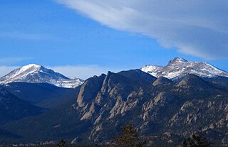
WThe Casual Route is the easiest technical climbing route up the Diamond of Longs Peak.
 W
WChasm Falls is a waterfall with a 25-foot (7.6 m) drop located on the Fall River in Rocky Mountain National Park.
 W
WThe Continental Divide National Scenic Trail is a United States National Scenic Trail running 3,100 miles (5,000 km) between Chihuahua and Alberta. It follows the Continental Divide of the Americas along the Rocky Mountains and traverses five U.S. states — Montana, Idaho, Wyoming, Colorado, and New Mexico. In Montana it crosses Triple Divide Pass The trail is a combination of dedicated trails and small roads and considered 70% complete. Portions designated as uncompleted must be traveled by roadwalking on dirt or paved roads. This trail can be continued north into Alberta and B.C., to Kawkawa Lake, B.C., north of Jasper National Park by the Great Divide Trail.
 W
WEstes Park is a statutory town in Larimer County, Colorado, United States. A popular summer resort and the location of the headquarters for Rocky Mountain National Park, Estes Park lies along the Big Thompson River. Estes Park had a population of 5,858 at the 2010 census. Landmarks include The Stanley Hotel and The Baldpate Inn. The town overlooks Lake Estes and Olympus Dam.
 W
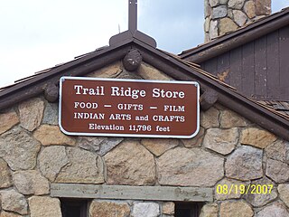
WFall River Pass is a mountain pass in northern Colorado, in the Rocky Mountains of the western United States. It is located in the Front Range, within Rocky Mountain National Park. The pass is traversed by U.S. Highway 34 on Trail Ridge Road between Granby and Estes Park. However, as at Milner Pass on the Continental Divide, the road does not descend after reaching the pass from the west, but instead continues to climb along a side ridge; thus, neither pass is the high point on Trail Ridge Road, which crests at 12,183 feet (3,713 m) elevation, east of Fall River Pass, still within Rocky Mountain National Park. On the other hand, the old, largely unpaved, and one-way-uphill Fall River Road does have its summit at Fall River Pass, where it joins the modern highway for the descent to the west.
 W
WHorseshoe Park is a flat at 8,524 feet (2,598 m) in elevation in Larimer County, Colorado. It is within the Rocky Mountain National Park, which lies between Estes Park to the east and Grand Lake, Colorado on the west. Horseshoe Park is home to bighorn sheep, elk and other wildlife, and it is a wetland sanctuary for wide variety of birds. Recreational activities include picnicking, hiking, cross-country skiing and snowshoeing. Roaring River, Lawn Lake and Crystal Lake are located here.
 W
WKawuneeche Valley, also known as Kawuneeche or Coyote Valley, is a marshy valley of the Colorado River near its beginning. It is located on the west side of Rocky Mountain National Park in Colorado. The axis of the valley runs almost directly north to south. Kawuneeche means "valley of the coyote" in Arapaho language and there is a Coyote Valley Trail head by US Route 34 in the western half of the park. Coyotes still live here, as do wapiti (elk), mule deer, moose, and mountain lion.
 W
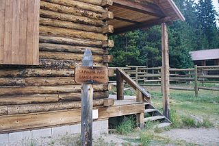
WLa Poudre Pass elevation 10,184 ft (3,104 m) is a high mountain pass located in the Rocky Mountains of northern Colorado in the United States.
 W
WElkanah J. Lamb was born in Indiana and moved westward through Iowa to Kansas and Nebraska during his early adulthood. He became a minister of the Church of the United Brethren and traveled through the Kansas and Nebraska frontier to preach to people in their homes or school houses. Lamb spent a year in Colorado as a missionary. During that time, he visited Estes Park and climbed Longs Peak. Lamb's slide on Longs Peak is named for his treacherous descent in 1871.
WLumpy Ridge is a prominent series of rocky cliffs, slabs, and buttresses adjacent to and north of the town of Estes Park, Colorado and lies inside of Rocky Mountain National Park and is known for rock climbing.
 W
WThere are 67 native species of mammals in Rocky Mountain National Park, a 265,461 acres (107,428 ha) park in Colorado. Species are listed by common name, scientific name, habitat, and abundance. Extirpated species are marked with an EX.
 W
WMiddle Park is a high basin in the Rocky Mountains of north-central Colorado in the United States. It is located in Grand County, on the southwest slope of Rocky Mountain National Park, approximately 50 miles (80 km) west of Boulder.
 W
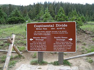
WMilner Pass, elevation 10,759 ft (3,279 m) is a mountain pass in the Rocky Mountains of northern Colorado in the United States. It is located on the continental divide in the Front Range, within Rocky Mountain National Park, along the boundary between Larimer and Grand counties. The pass provides the passage over the continental divide for US 34, also known as Trail Ridge Road between Estes Park and Grand Lake. The pass is not, however, the high point on Trail Ridge Road, which crests at 12,183 ft (3,713 m) east of the pass within Rocky Mountain National Park. Along with the rest of Trail Ridge Road, the pass is generally closed in winter from the first heavy snow fall until the opening of the road around Memorial Day. The gentle pass divides the headwaters of the Cache la Poudre River and several creeks near the headwaters of the Colorado River to the west. The road near the pass provides a panoramic view of the Never Summer Mountains to the west.
 W
WThe Mummy Range is a mountain range in the Rocky Mountains of northern Colorado in the United States. The range is a short subrange of the Front Range located in southwestern Larimer County northwest of the town of Estes Park. It is located largely within Rocky Mountain National Park, extending north from Trail Ridge Road approximately 15 miles (24 km). The Arapaho name is "nooku-bee3ei-no," which translates to "White Owls."
 W
WThe Never Summer Mountains are a mountain range in the Rocky Mountains in north central Colorado in the United States consisting of seventeen named peaks. The range is located along the northwest border of Rocky Mountain National Park, forming the continental divide between the headwaters of the Colorado River in Rocky Mountain National Park to the local-east and the upper basin of the North Platte River to the local-west; the continental divide makes a loop in these mountains. The range is small and tall, covering only 25 sq mi (65 km2) with a north-south length of 10 mi (16 km) while rising to over 12,000 ft (3,700 m) at over ten distinct peaks. The range straddles the Jackson-Grand county line for most of its length, and stretches into Jackson and Larimer county at its northern end. A panoramic view of the range is available from sections of Trail Ridge Road in Rocky Mountain National Park. One of the northernmost peaks, Nokhu Crags, is prominently visible from the west side of Cameron Pass.
 W
WThe Northcutt-Carter Route is a popular technical climbing route on Hallett Peak in Colorado's Rocky Mountain National Park. The Northcutt-Carter Route is recognized in the historic climbing text Fifty Classic Climbs of North America.
 W
WPetit Grepon is a semi-detached spire in Colorado's Rocky Mountain National Park. It is one of the "Cathedral Spires" which also includes Sharkstooth, The Saber, and The Foil. The South Face route of Petit Grepon is recognized in the historic climbing text Fifty Classic Climbs of North America and considered a classic around the world.
 W
WThe Poudre Canyon is a narrow verdant canyon, approximately 40 mi (64 km) long, on the upper Cache la Poudre River in Larimer County, Colorado in the United States. The canyon is a glacier-formed valley through the foothills of the Front Range of the Rocky Mountains northwest of Fort Collins.
 W
WStone Man Pass, elevation 12,506 ft (3,812 m), is a mountain pass that crosses the Continental Divide in Rocky Mountain National Park in Colorado in the United States.
 W
WUpper Beaver Meadows is a montane meadow and visitor attraction in Rocky Mountain National Park in Colorado. The area is known as a good bird-watching spot and its trail leads to a number of other trails within the park. The trails may be used for hiking, snowshoeing, or cross-country skiing.
 W
WWild Basin a region in the southeast corner Rocky Mountain National Park in Colorado, United States. The primary entrance is located north of Allenspark off State Highway 7.