 W
WArakan is a historic coastal region in Southeast Asia. Its borders faced the Bay of Bengal to its west, the Indian subcontinent to its north and Burma proper to its east. The Arakan Mountains isolated the region and made it accessible only by the Indian subcontinent and the sea. The region now forms the Rakhine State in Myanmar.
 W
WBritish rule in Burma lasted from 1824 to 1948, from the successive three Anglo-Burmese wars through the creation of Burma as a Province of British India to the establishment of an independently administered colony, and finally independence. The region under British control was known as British Burma. Various portions of Burmese territories, including Arakan or Tenasserim were annexed by the British after their victory in the First Anglo-Burmese War; Lower Burma was annexed in 1852 after the Second Anglo-Burmese War. The annexed territories were designated the minor province of British India in 1862.
 W
WThe Hanthawaddy Kingdom was the polity that ruled lower Burma (Myanmar) from 1287 to 1539 and from 1550 to 1552. The Mon-speaking kingdom was founded as Ramaññadesa by King Wareru following the collapse of the Pagan Empire in 1287 as a nominal vassal state of the Sukhothai Kingdom and of the Mongol Yuan dynasty. The kingdom became formally independent of Sukhothai in 1330 but remained a loose federation of three major regional power centres: the Irrawaddy Delta, Bago, and Mottama. Its kings had little or no authority over the vassals. Mottama was in open rebellion from 1363 to 1388.
 W
WThe Karenni States, also known as Red Karen States, was the name formerly given to the states inhabited mainly by the Red Karen, in the area of present-day Kayah State, eastern Burma. They were located south of the Federated Shan States and east of British Burma.
WArakan is a historic coastal region in Southeast Asia. Its borders faced the Bay of Bengal to its west, the Indian subcontinent to its north and Burma proper to its east. The Arakan Mountains isolated the region and made it accessible only by the Indian subcontinent and the sea. The region now forms the Rakhine State in Myanmar.
 W
WThe Konbaung dynasty, formerly known as the Alompra dynasty, or Alaungpaya dynasty, was the last dynasty that ruled Burma/Myanmar from 1752 to 1885. It created the second-largest empire in Burmese history and continued the administrative reforms begun by the Toungoo dynasty, laying the foundations of the modern state of Burma. The reforms, however, proved insufficient to stem the advance of the British, who defeated the Burmese in all three Anglo-Burmese wars over a six-decade span (1824–1885) and ended the millennium-old Burmese monarchy in 1885.
 W
WThe Lao Kingdom of Lan Xang Hom Khao existed as a unified kingdom from 1353 to 1707.
 W
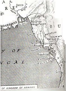
WThe Kingdom of Mrauk-U was an independent coastal kingdom of Arakan which existed for over 350 years. It was based in the city of Mrauk-U, near the eastern coast of the Bay of Bengal. The kingdom from 1429 to 1785 ruled over what is now Rakhine State, Myanmar and Chittagong Division, Bangladesh. From 1429 to 1531 it was a protectorate of the Bengal Sultanate at different time periods. After gaining independence from Bengal, it prospered with help from the Portuguese settlement in Chittagong. In 1666, it lost control of Chittagong after a war with the Mughal Empire. Its reign continued until the 18th century, when it fell to the invasion of the Burmese Empire.
 W
WThe Myinsaing Kingdom was the kingdom that ruled central Burma (Myanmar) from 1297 to 1313. Co-founded by three brothers from Myinsaing, it was one of many small kingdoms that emerged following the collapse of Pagan Empire in 1287. Myinsaing successfully fended off the second Mongol invasion in 1300–01, and went on to unify central Burma from Tagaung in the north to Prome (Pyay) in the south. The brothers' co-rule ended between 1310 and 1313, with the death of the two elder brothers. In 1315, the central Burmese state split into two rival states of Pinya and Sagaing. Central Burma would not be reunified until the rise of Ava five decades later.
 W
WEarly Pagan Kingdom was a city-state that existed in the first millennium CE before the emergence of Pagan Empire in the mid 11th century. The Burmese chronicles state that the "kingdom" was founded in the second century CE. The seat of power of the small kingdom was first located at Arimaddana, Thiri Pyissaya, and Tampawaddy until 849 CE when it was moved to Pagan (Bagan).
 W
WThe Kingdom of Pagan was the first kingdom to unify the regions that would later constitute modern-day Burma (Myanmar). Pagan's 250-year rule over the Irrawaddy valley and its periphery laid the foundation for the ascent of Burmese language and culture, the spread of Burman ethnicity in Upper Burma, and the growth of Theravada Buddhism in Burma and in mainland Southeast Asia.
 W
WThe Pinya Kingdom was the kingdom that ruled Central Myanmar (Burma) from 1313 to 1365. It was the successor state of Myinsaing, the polity that controlled much of Upper Burma between 1297 and 1313. Founded as the de jure successor state of the Pagan Empire by Thihathu, Pinya faced internal divisions from the start. The northern province of Sagaing led by Thihathu's eldest son Saw Yun successfully fought for autonomy in 1315−17, and formally seceded in 1325 after Thihathu's death.
WThe Sagaing Kingdom was a small kingdom ruled by a junior branch of the Myinsaing dynasty from 1315 to 1365. Originally the northern province of Sagaing of the Pinya Kingdom, it became de facto independent after Prince Saw Yun successfully fought for autonomy from his father King Thihathu in 1315–17. Sagaing formally seceded from Pinya in 1325 after Thihathu's death.
 W
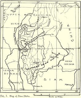
WThe Shan States (1885–1948) were a collection of minor Shan kingdoms called muang whose rulers bore the title saopha in British Burma. They were analogous to the princely states of British India.
 W
WThe Burmese Way to Socialism was the ideology of the military dictatorship in Burma under the Burma Socialist Programme Party (BSPP) from 1962 to 1988.
WSri Ksetra, located along the Irrawaddy River at present-day Hmawza, was once a prominent Pyu settlement. The Pyu occupied several sites across Upper Myanmar, with Sri Ksetra recorded as the largest, the city wall enclosing an area of 1,477 hectares, although a recent survey found it enclosed 1,857 hectares within its monumental brick walls, with an extramural area of a similar size, being the largest Southeast Asian city before Angkor times. Issues surrounding the dating of this site has meant the majority of material is dated between the seventh and ninth centuries AD, however recent scholarship suggests Pyu culture at Sri Ksetra was active centuries before this.
WTagaung Kingdom was a Pyu city-state that existed in the first millennium CE. In 1832, the hitherto semi-legendary state was officially proclaimed the first kingdom of Burmese monarchy by Hmannan Yazawin, the Royal Chronicle of the Konbaung Dynasty. Hmannan adds that the "kingdom" was founded by Abhiyaza of the Sakya clan of the Buddha in 850 BCE, and that through Abiyaza, Burmese monarchs traced their lineage to the Buddha and the first Buddhist (mythical) king of the world Maha Sammata. Hmannan also introduces another Sakya prince Dazayaza who founded the second Tagaung dynasty c. 600 BCE. The narrative superseded then prevailing pre-Buddhist origin story in which the monarchy was founded by a descendant of a solar spirit and a dragon princess.
 W
WThe Toungoo dynasty, and also known as the Restored Toungoo dynasty, was the ruling dynasty of Burma (Myanmar) from the mid-16th century to 1752. Its early kings Tabinshwehti and Bayinnaung succeeded in reunifying the territories of the Pagan Kingdom for the first time since 1287 and in incorporating the Shan States for the first time. At its peak, the First Toungoo Empire also included Manipur, Chinese Shan States, Siam and Lan Xang. But the largest empire in the history of Southeast Asia collapsed in the 18 years following Bayinnaung's death in 1581.
WThe First Toungoo Empire was the dominant power in mainland Southeast Asia in the second half of the 16th century. At its peak, Toungoo "exercised suzerainty from Manipur to the Cambodian marches and from the borders of Arakan to Yunnan" and was "probably the largest empire in the history of Southeast Asia." The "most adventurous and militarily successful" dynasty in Burmese history was also the "shortest-lived."
 W
WDuring the first years of post-independence Burma, insurgencies by the Red Flag Communists led by Thakin Soe, the White Flag Communists led by Thakin Than Tun, the Yèbaw Hpyu led by Bo La Yaung, a member of the Thirty Comrades, army rebels calling themselves the Revolutionary Burma Army (RBA) led by communist officers Bo Zeya, Bo Yan Aung and Bo Yè Htut – all three of them members of the Thirty Comrades, Arakanese, and the Karen National Union (KNU).
 W
WWaithali located in today's northern Rakhine State, Myanmar, was the capital of the Waithali Kingdom from 788 to 1018. The former capital site is approximately 70 kilometres (43 mi) north-east of Sittwe, and east of Ram Chaung, a tributary of the Kaladan river. Like much of northern Rakhine State, Waithali is in a hilly locale. Like its predecessor, Dhanyawadi, the former capital site has fallen into ruin and much of it is now deserted. Only a few temples and traces of the old city wall remain. The site is about an hour's bus ride from Mrauk U.