 W
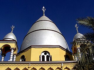
WAl Amarat Al Amarat is a large district and one of the most prestigious neighbourhoods in Khartoum city.
 W
WAlmorada is an ancient district in Omdurman city, Khartoum State, Sudan. Almorada neighborhood is one of the most prestigious district in the Eastern part of Omdurman city.
WBant is an affluent district in Omdurman city, Khartoum State, Sudan. south-western part of the ancient city of Omdurman.
 W
WFaras was a major city in Lower Nubia. The site of the city, on the border between modern Egypt and Sudan at Wadi Halfa Salient, was flooded by Lake Nasser in the 1960s and is now permanently underwater. Before this flooding, extensive archaeological work was conducted by a Polish archaeological team led by professor Kazimierz Michałowski.
 W
WKaranog was a Kushite town in Lower Nubia on the west bank of the Nile. It was probably a provincial capital under its own peshto (governor) in the second and third centuries AD. It was excavated between 1907 and 1910 by David Randall-MacIver and Leonard Woolley of the University of Pennsylvania Museum.
 W
WKawa is a site in Sudan, located between the Third and Fourth Cataracts of the Nile on the east bank of the river, across from Dongola. In ancient times it was the site of several temples to the Egyptian god Amun, built by the Egyptian rulers Amenhotep III and Tutankhamun, and by Taharqa and other Kushite kings.
 W
WKerma was the capital city of the Kerma culture, which was located in present-day Sudan at least 5500 years ago. Kerma is one of the largest archaeological sites in ancient Nubia. It has produced decades of extensive excavations and research, including thousands of graves and tombs and the residential quarters of the main city surrounding the Western/Lower Deffufa.
 W
WKorosko was a settlement on the Nile River in Egyptian Nubia. It was located 118 miles (190 km) south of Aswan and served as the point of departure for caravans avoiding the Dongola bend in the river by striking out directly across the desert to Abu Hamad and thereby bypassing the second, third and fourth cataracts of the Nile. The "Korosko route" or "Korosoko road" was in use during the period of the New Kingdom, when Pharaohs Thutmose I and Thutmose III marked it with boundary stelae. During the Meroitic period it was the main connection between the Kingdom of Kush and the Mediterranean world.
 W
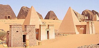
WMeroë was an ancient city on the east bank of the Nile about 6 km north-east of the Kabushiya station near Shendi, Sudan, approximately 200 km north-east of Khartoum. Near the site is a group of villages called Bagrawiyah. This city was the capital of the Kingdom of Kush for several centuries from around 590 BC, until its collapse in the fourth century CE. The Kushitic Kingdom of Meroë gave its name to the "Island of Meroë", which was the modern region of Butana, a region bounded by the Nile, the Atbarah and the Blue Nile.
WNapata was a city of ancient Kush at the fourth cataract of the Nile. It is located approximately 1.5 kilometers from the right side of the river at the site of modern Karima, Sudan. It was the southernmost permanent settlement in the New Kingdom of Egypt and home to Jebel Barkal, the main Kushite cult centre of Amun. It was the sometime capital of the Twenty-fifth Dynasty of Egypt and, after its fall in 663 BC, of the Kingdom of Kush. In 593 BC, it was sacked by the Egyptians and the Kushite capital was relocated to Meroë. Even after this move, Napata continued to be the kingdom's primary religious centre. The city was sacked a second time by the Romans in 23 BC but was rebuilt and continued as an important centre of the Amun cult.
 W
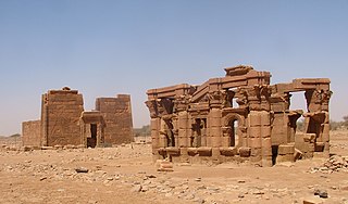
WNaqa or Naga'a is a ruined ancient city of the Kushitic Kingdom of Meroë in modern-day Sudan. The ancient city lies about 170 km (110 mi) north-east of Khartoum, and about 50 km (31 mi) east of the Nile River located at approximately MGRS 36QWC290629877. Here smaller wadis meet the Wadi Awateib coming from the center of the Butana plateau region, and further north at Wad ban Naqa from where it joins the Nile. Naqa was only a camel or donkey's journey from the Nile, and could serve as a trading station on the way to the east; thus it had strategic importance.
WKerma was the capital city of the Kerma culture, which was located in present-day Sudan at least 5500 years ago. Kerma is one of the largest archaeological sites in ancient Nubia. It has produced decades of extensive excavations and research, including thousands of graves and tombs and the residential quarters of the main city surrounding the Western/Lower Deffufa.
 W
WSoba is an archaeological site and former town in what is now central Sudan. Three kingdoms existed in medieval Nubia: Nobadia with the capital in Faras, Makuria with the capital in Dongola, and Alodia (Alwa) with the capital in Soba. The latter used to be the capital of the medieval Nubian kingdom of Alodia from the sixth century until around 1500. E. A. Wallis Budge identified it with a group of ruins on the Blue Nile 19 kilometres (12 mi) from Khartoum, where there are remains of a Meroitic temple that had been converted into a Christian church.
 W
WUronarti, a Nubian word meaning "Island of the King", is an island in the Nile just south of the Second Cataract in the north of Sudan. The primary importance of the island lies in the massive ancient fortress that still stands on its northern end. This fortress is one of a number constructed along the Nile in Lower Nubia during the Middle Kingdom, primarily by the rulers Senusret I and Senusret III.
 W
WWad ben Naga is the name of an ancient town of the Kushitic Kingdom of Meroë in present-day Sudan. The village lies on the eastern bank of the Nile, about 80 kilometers upstream of Meroë and about 40 km southwest of Shendi.