 W
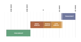
WThe history of Nunavut covers the period from the arrival of the Paleo-Eskimo thousands of years ago to present day. Prior to the colonization of the continent by Europeans, the lands encompassing present-day Nunavut were inhabited by several historical cultural groups, including the Pre-Dorset, the Dorsets, the Thue and their descendants, the Inuit.
 W
WThe Canadian Arctic Expedition 1913–1916 was a scientific expedition in the Arctic Circle organized and led by Vilhjalmur Stefansson. The expedition was originally to be sponsored by the (US) National Geographic Society and the American Museum of Natural History. Canada took over the sponsorship because of the potential for discovery of new land and Stefansson, who though born in Canada was now an American, re-established his Canadian citizenship. The expedition was divided into a Northern Party led by Stefansson, and a Southern Party led by R M. Anderson.
 W
WThe Coppermine expedition was a British overland undertaking to survey and chart the area from Hudson Bay to the north coast of Canada, eastwards from the mouth of the Coppermine River. The expedition was organised by the Royal Navy as part of its attempt to discover and map the Northwest Passage. It was the first of three Arctic expeditions to be led by John Franklin and also included George Back and John Richardson, both of whom would become notable Arctic explorers in their own right.
 W
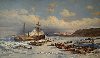
WFranklin's lost expedition was a British voyage of Arctic exploration led by Captain Sir John Franklin that departed from England in 1845 aboard two ships, HMS Erebus and HMS Terror, and was assigned to traverse the last unnavigated sections of the Northwest Passage in the Canadian Arctic. The expedition met with disaster after both ships and their crews, a total of 129 officers and men, became icebound in Victoria Strait near King William Island, in what is today the Canadian territory of Nunavut. After being icebound for more than a year, Erebus and Terror were abandoned in April 1848, by which point Franklin and nearly two dozen others had died. The survivors, now led by Franklin's deputy Francis Crozier and Erebus' captain James Fitzjames, set out for the Canadian mainland and disappeared.
 W
WThe history of Northwest Territories capital cities begins with the purchase of the Territories by Canada from the Hudson's Bay Company in 1869, and includes a varied and often difficult evolution. Northwest Territories is unique amongst the other provinces and territories of Canada in that it has had seven capital cities in its history. The territory has changed the seat of government for numerous reasons, including civil conflict, development of infrastructure, and a history of significant revisions to its territorial boundaries.
 W
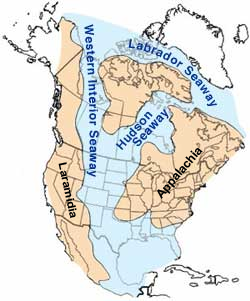
WThe Hudson Seaway was a major seaway of North America during the Cretaceous Period some 75 million years ago. It is named after the Hudson Bay, which currently occupies much of its extent. Although not as extensive as the Western Interior Seaway, which divided North America into eastern and western landmasses, the Hudson Seaway had major impacts on climate and migration routes by dividing the eastern half of the continent into two. Greenland was more permanently separated, by the foundered rift that created the Labrador Seaway.
 W
WThe MacGregor Arctic Expedition was a privately funded expedition which set out to reoccupy Fort Conger, Ellesmere Island, Canada, a site within flying distance of the North Pole. The expedition, which took place from July 1, 1937, to October 3, 1938, had four main objectives: To collect weather data; to make a magnetic survey; to photograph the aurora borealis and study its effects upon radio transmission; and to explore the area northwest of Ellesmere Island, in order to clear up the questions about Crocker Land, which Robert Peary placed on the map more than 30 years earlier.
 W
WThe Mackenzie River expedition of 1825–1827 was the second of three Arctic expeditions led by explorer John Franklin and organized by the Royal Navy. It had as its goal the exploration of the North American coast between the mouths of the Mackenzie and Coppermine rivers and the Bering Strait, in what is now present-day Alaska, Yukon, the Northwest Territories, and Nunavut. Franklin was accompanied by George Back and John Richardson, both of whom he had previously collaborated with during the disastrous Coppermine expedition of 1819–1821. Unlike Franklin's previous expedition, this one was largely successful, and resulted in the mapping of more than 1,000 kilometres (620 mi) of new coastline between the Kent Peninsula and Prudhoe Bay, Alaska, an area that until then had remained largely unexplored by Europeans.
 W
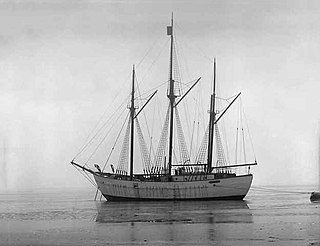
WMaud, named for Queen Maud of Norway, was a ship built for Roald Amundsen for his second expedition to the Arctic. Designed for his intended voyage through the Northeast Passage, the vessel was built in Asker, a suburb of the capital, Oslo.
 W
WNative Point is a peninsula in Kivalliq Region, Nunavut, Canada. It is located on Southampton Island's Bell Peninsula at the mouth of Native Bay. It is notable for being the location of an abandoned Sadlermiut settlement, currently an archaeological site.
 W
WParker's Notch, named after former Commissioner of the Northwest Territories, John Havelock Parker, is a protrusion of the Northwest Territories southwards into Nunavut on Victoria Island. In the Northwest Territories the protrusion is part of the Inuvik Region and the Kitikmeot Region in Nunavut.
 W
WThe Polaris expedition of 1871–1873 was a United States Government-funded undertaking and one of the first serious attempts to reach the North Pole, after that of British naval officer Sir Edward Parry, who reached 82° 45′ N in 1827. The expedition's notable achievement was reaching 82° 29′ N by ship, a record at the time.
 W
WSaqvaqjuac was a 465 m2 Arctic research camp located on the north side of Chesterfield Inlet, Kivalliq Region, Nunavut, Canada, 35 km north-northwest of the hamlet of Chesterfield Inlet. It was opened in 1977, operated every year until 1982, and last used in 1988. Research subjects included whole-lake methane addition, phosphorus and nitrogen eutrophication experiments, and long-range atmospheric transport. The project was operated by the Freshwater Institute, part of Fisheries and Oceans Canada.