 W
WBanovina or Banija is a geographical region in central Croatia, between the Sava, Una, Kupa and Glina rivers. The main towns in the region include Petrinja, Glina, Kostajnica, and Dvor. There is no clear geographical border of the region towards the west and the neighboring region of Kordun. The area of Banovina is today administratively almost entirely located within the Sisak-Moslavina County.
 W
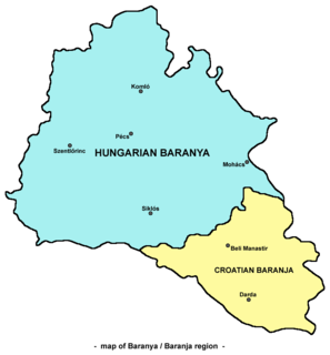
WBaranya or Baranja is a geographical and historical region between the Danube and the Drava rivers. Its territory is divided between Hungary and Croatia. In Hungary, the region is included into Baranya county, while in Croatia, it is included into Osijek-Baranja county.
 W
WDalmatia is one of the four historical regions of Croatia, alongside Croatia proper, Slavonia, and Istria.
 W
WDalmatian Hinterland is the southern inland hinterland in the historical Croatian region of Dalmatia. The name zagora means "beyond (the) hills", which is a reference to the fact that it is the part of Dalmatia that is not coastal.
 W
WDélvidék is a historical political term referring to varying areas in the southern part of what was the Kingdom of Hungary. In present-day usage, it often refers to the Vojvodina region of Serbia.
 W
WHrvatsko zagorje is a cultural region in northern Croatia, traditionally separated from the country's capital Zagreb by the Medvednica Mountain. It comprises the whole area north of Mount Medvednica up to Slovenia in the north and west, and up to the regions of Međimurje and Podravina in the north and east. The population of Zagorje is not recorded as such, as it is administratively divided among Krapina-Zagorje County, and western and central part of Varaždin County. The population of Zagorje can be reasonably estimated to exceed 300,000 people.
 W
WThe Kordun region is a part of central Croatia from the bottom of the Petrova Gora mountain range, which extends along the rivers Korana and Slunjčica, and forms part of the border region to Bosnia and Herzegovina. Within Croatia, Kordun is bordered by the Lika region to the south and by Banovina or Banija to the east. Most of Kordun with its centre Slunj belongs to Karlovac County. Vrginmost belongs to Sisak-Moslavina County. In former times, this region belonged to the Habsburg Military Frontier towards the Ottoman Empire.
 W
WLika is a traditional region of Croatia proper, roughly bound by the Velebit mountain from the southwest and the Plješevica mountain from the northeast. On the north-west end Lika is bounded by Ogulin-Plaški basin, and on the south-east by the Malovan pass. Today most of the territory of Lika is part of Lika-Senj County. Josipdol, Plaški and Saborsko are part of Karlovac County and Gračac is part of Zadar County.
 W
WMeđimurje is a small historical and geographical region in Northern Croatia comprising the area between the two large rivers, Mura and Drava, and roughly corresponding to the administrative division of Međimurje County.
 W
WThe Požega Valley is a geographic microregion of Croatia, located in central Slavonia, encompassing the eastern part of the Požega-Slavonia County. It is located in the Pannonian Basin, bounded by Psunj, Papuk and Krndija mountains from west and north, and Požeška Gora and Dilj from south and east, as the Pannonian plain is interspersed by horst and graben structures. The largest settlement in the region is the city of Požega, followed by Pleternica and Kutjevo. The main watercourse in the region is Orljava River. The region covers 1,249 square kilometres and has a population of 60,599.
 W
WSlavonia is, with Dalmatia, Croatia proper and Istria, one of the four historical regions of Croatia. Taking up the east of the country, it roughly corresponds with five Croatian counties: Brod-Posavina, Osijek-Baranja, Požega-Slavonia, Virovitica-Podravina and Vukovar-Syrmia, although the territory of the counties includes Baranya, and the definition of the western extent of Slavonia as a region varies. The counties cover 12,556 square kilometres or 22.2% of Croatia, inhabited by 806,192—18.8% of Croatia's population. The largest city in the region is Osijek, followed by Slavonski Brod and Vinkovci.
 W
WSyrmia is a region of the southern Pannonian Plain, which lies between the Danube and Sava rivers. It is divided between Serbia and Croatia. Most of the region is flat, with the exception of the low Fruška gora mountain stretching along the Danube in its northern part.