 W
WAlbany is a city on the east shore of San Francisco Bay in northwestern Alameda County, California. The population was 18,539 at the 2010 census and is estimated to be 19,696 in 2019.
 W
WAño Nuevo State Marine Conservation Area (SMCA) is one of two adjoining marine protected areas off the coast of San Mateo and Santa Cruz Counties, on California’s central coast. The area is approximately 55 miles south of San Francisco. The SMCA is 11.07 square miles. Except for limited taking of giant kelp, all living marine resources are protected.
 W
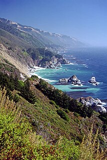
WAño Nuevo State Park is a state park of California, USA, encompassing Año Nuevo Island and Año Nuevo Point, which are known for their pinniped rookeries. Located in San Mateo County, the low, rocky, windswept point juts out into the Pacific Ocean about 55 miles (89 km) south of San Francisco and the Golden Gate. Año Nuevo State Natural Reserve, formerly a separate unit of the California state park system, was merged into Año Nuevo State Park in October 2008. The coastal geographic center, or coastal-midpoint of California is located at the Northern end of this park at N 37°09′58″, W 122°21'40", as the absolute geographic center of California falls at N 37°09′58″, W 119°26′58″W.
 W
WAsilomar State Marine Reserve (SMR) is one of four small marine protected areas (MPAs) located near the cities of Monterey and Pacific Grove, at the southern end of Monterey Bay on California’s central coast. The four MPAs together encompass 2.96 square miles (7.7 km2). The SMR protects all marine life within its boundaries. Fishing and take of all living marine resources is prohibited.
 W
WBair Island is a marsh area in Redwood City, California, covering 3,000 acres (1,200 ha), and includes three islands: Inner, Middle and Outer islands. Bair Island is part of the larger Don Edwards San Francisco Bay National Wildlife Refuge. It is surrounded by the Steinberger slough to the northwest and Redwood Creek to the southeast.
 W
WBig Creek State Marine Reserve (SMR) and Big Creek State Marine Conservation Area (SMCA) are two adjoining marine protected areas that lie offshore of Big Sur on California's central coast. The combined area of these marine protected areas is 22.45 square miles (58.1 km2). The SMR protects all marine life within its boundaries. Fishing and take of all living marine resources is prohibited. Within the SMCA fishing and take of all living marine resources is prohibited except the commercial and recreational take of salmon, albacore, and the commercial take of spot prawn.
 W
WThe California Coastal National Monument is located along the entire coastline of the U.S. state of California. This monument ensures the protection of all islets, reefs and rock outcroppings along the coast of California within 12 nautical miles (22 km) of shore along the entire 840-mile (1,350 km) long coastline. Conservative estimates are for at least 20,000 such outcroppings. The monument was created by Bill Clinton via Presidential proclamation on January 11, 2000, with the authority in section two of the Antiquities Act of 1906. As of 2014, the monument has expanded to 2,272 acres (919 ha). The U.S. Bureau of Land Management, an agency of the U.S. Department of the Interior that manages the monument, has developed gateways in cooperation with other agencies along the California coast to introduce the monument to the public. These include the Trinidad Gateway, Point Arena Gateway, Fort Bragg-Mendocino Gateway, Pigeon Point Gateway, Piedras Blancas-San Simeon Gateway, and Palos Verdes Peninsula Gateway. The California Coastal National Monument is one of the most-viewed national monuments in California, although people are usually unaware that they are viewing a national monument.
 W
WCambria State Marine Conservation Area (SMCA) is a marine protected area located off the coast of the city of Cambria, California on California’s central coast in San Luis Obispo County, California. The marine protected area covers 6.26 square miles (16.2 km2). Within the SMCA recreational fishing and take is allowed while commercial fishing and take of all living marine resources is prohibited.
 W
WCarmel Bay State Marine Conservation Area (SMCA) is a marine protected area in Carmel Bay. Carmel Bay is adjacent to the city of Carmel-by-the-Sea and is near Monterey, on California’s central coast. The marine protected area covers 2.12 square miles. Recreational fishing of finfish and limited commercial taking of kelp is permitted within the SMCA.
WCarmel Pinnacles State Marine Reserve (SMR) is a marine protected area in Carmel Bay including a unique underwater pinnacle formation with adjacent kelp forest, submarine canyon head, and surfgrass. Carmel Bay is adjacent to the city of Carmel-by-the-Sea and is near Monterey, on California’s central coast.
 W
WThe Channel Islands National Marine Sanctuary is a sanctuary off the Pacific coast of Southern California. The National Marine Sanctuary program is administered by the National Oceanic and Atmospheric Administration.
 W
WCordell Bank National Marine Sanctuary is a marine sanctuary located off the coast of California. It protects an area of 1,286 sq mi (3,331 km2) of marine wildlife. The administrative center of the sanctuary is on an offshore granite outcrop 4.5 sq mi (12 km2) by 9.5 sq mi (25 km2), located on the continental shelf off of California. The outcrop is, at its closest, 6 mi (10 km) from the sanctuary itself.
 W
WDel Mar Landing State Marine Reserve (SMR) is a marine protected area that lies onshore, about two miles (3 km) south of the town of Gualala and three and a half miles north of Sea Ranch in Sonoma County on California’s north central coast. The marine protected area covers 0.22 square miles (0.57 km2). Del Mar Landing SMR prohibits the take of all living marine resources.
 W
WDuxbury Reef State Marine Conservation Area (SMCA) is a marine protected area located about 1 mile (2 km) west of Bolinas in Marin County on California’s north central coast. This marine protected area covers 0.66 square miles (1.7 km2). Duxbury Reef SMCA prohibits the take of all living marine resources, except the recreational take of finfish from shore only and the recreational take of abalone.
 W
WEdward F. Ricketts State Marine Conservation Area is one of four small marine protected areas located near the cities of Monterey and Pacific Grove, at the southern end of Monterey Bay on California’s central coast. The four areas together encompass 2.96 square miles (7.7 km2). Within SMCAs fishing and take of all living marine resources is prohibited except the recreational take of finfish by hook-and-line and the commercial take of giant and bull kelp under certain conditions.
 W
WElkhorn Slough is a 7-mile-long (11 km) tidal slough and estuary on Monterey Bay in Monterey County, California. The community of Moss Landing and the Moss Landing Power Plant are located at the mouth of the slough on the bay.
WElkhorn Slough is a 7-mile-long (11 km) tidal slough and estuary on Monterey Bay in Monterey County, California. The community of Moss Landing and the Moss Landing Power Plant are located at the mouth of the slough on the bay.
 W
WEstero Americano State Marine Recreational Management Area (SMRMA) is a marine protected area that splits Sonoma and Marin counties on California’s north central coast. The marine protected area covers 0.15 square miles. Estero Americano SMRMA prohibits the take of all living marine resources, except the recreational hunting of waterfowl, unless otherwise restricted by hunting regulations.
WEstero de Limantour State Marine Reserve (SMR) and Drakes Estero State Marine Conservation Area (SMCA) are two adjoining marine protected areas along the Point Reyes National Seashore in Marin County on California’s north central coast. These marine protected areas cover a combined 4.04 square miles (10.5 km2), with 1.49 square miles (3.9 km2) in the SMR and 2.55 square miles (6.6 km2) in the SMCA. Drakes Estero SMCA prohibits the take of all living marine resources from Drakes Estero except the recreational take of clams and formerly the commercial aquaculture of shellfish pursuant to a disputed state water bottom lease and permit, which has been the subject of ongoing legal proceedings since 2012, when the lease was allowed to expire.
 W
WEstero de San Antonio State Marine Recreational Management Area (SMRMA) is a marine protected area 1.5 miles north of Dillon Beach in Marin County on California’s north central coast. The marine protected area covers 0.09 square miles. Estero de San Antonio SMRMA prohibits the take of all living marine resources, except the recreational hunting of waterfowl, unless otherwise restricted by hunting regulations.
 W
WFitzgerald Marine Reserve is a marine reserve in California on the Pacific Ocean, located just north of Pillar Point Harbor and Mavericks in the San Mateo County community of Moss Beach. Moss Beach is located approximately 20 miles (32 km) south of San Francisco and 50 miles (80 km) north of Santa Cruz. The reserve is a 32-acre (0.13 km2) holding which extends from Montara light station at the north to Pillar Point on the south. The reserve consists of a three-mile stretch of beach, tidepool habitat, marsh, erosive bluffs, clifftop trail and cypress and eucalyptus forests. The property is owned by the State of California and managed by San Mateo County as a county park and nature preserve. The reserve is administratively assigned to be part of the Monterey Bay National Marine Sanctuary. Adjacent to and possibly within the reserve is an endangered species of butterfly, the San Bruno elfin butterfly.
 W
WThe Greater Farallones National Marine Sanctuary protects the wildlife, habitats, and cultural resources of one of the most diverse and bountiful marine environments in the world, an area of 3,295 square miles off the northern and central California coast. The waters within Greater Farallones National Marine Sanctuary are part of a nationally significant marine ecosystem, and support an abundance of life, including many threatened or endangered species.
 W
WGreyhound Rock State Marine Conservation Area (SMCA) is one of two adjoining marine protected areas off the coast of San Mateo County and Santa Cruz County, on California's central coast. The area is approximately 55 miles (89 km) south of San Francisco. The SMCA is 11.81 square miles (30.6 km2). Within the SMCA fishing and take of all living marine resources is prohibited except the recreational take of giant kelp, squid, salmon, and other finfish, subject to various conditions. Also permitted is the commercial take of giant kelp, salmon, and squid, subject to various conditions.
WThe Greater Farallones National Marine Sanctuary protects the wildlife, habitats, and cultural resources of one of the most diverse and bountiful marine environments in the world, an area of 3,295 square miles off the northern and central California coast. The waters within Greater Farallones National Marine Sanctuary are part of a nationally significant marine ecosystem, and support an abundance of life, including many threatened or endangered species.
 W
WKent Island is a small island in Marin County, California. In 1964 it was proposed for large-scale development including a hotel and marina, but the plan was defeated in 1967. The island is now included in the Greater Farallones National Marine Sanctuary.
WLovers Point State Marine Reserve (SMR) is one of four small marine protected areas located near the cities of Monterey and Pacific Grove, at the southern end of Monterey Bay on California’s central coast. The four MPAs together encompass 2.96 square miles (7.7 km2). The SMR protects all marine life within its boundaries. Fishing and take of all living marine resources is prohibited.
 W
WMontara State Marine Reserve (SMR) and Pillar Point State Marine Conservation Area (SMCA) are two adjoining marine protected areas that extend offshore from Montara to Pillar Point in San Mateo County on California’s north central coast. The combined area of these marine protected areas is 18.42 square miles (47.7 km2), with 11.76 square miles (30.5 km2) in the SMR and 6.66 in the SMCA. Montara SMR prohibits the take of all living marine resources. Pillar Point SMCA prohibits the take of all living marine resources, except the recreational and commercial take of pelagic finfish by trolling or seine, the commercial or recreational take of Dungeness crab by trap and the commercial or recreational take or market squid by hand-held dip net or round haul net.
 W
WThe Monterey Bay National Marine Sanctuary (MBNMS) is a US Federally protected marine area offshore of California's Big Sur and central coast. It is the largest US national marine sanctuary and has a shoreline length of 276 miles (444 km) stretching from just north of the Golden Gate Bridge at San Francisco to Cambria in San Luis Obispo County. Supporting one of the world’s most diverse marine ecosystems, it is home to numerous mammals, seabirds, fishes, invertebrates and plants in a remarkably productive coastal environment. The MBNMS was established in 1992 for the purpose of resource protection, research, education, and public use.
 W
WMoro Cojo Estuary State Marine Reserve (SMR) is a marine protected area established to protect the wildlife and habitats in Moro Cojo Slough. Moro Cojo Slough is located inland from Monterey Bay on the central coast of California, directly south of the more widely known Elkhorn Slough. The area covers 0.46 square miles (1.2 km2). The SMR protects all marine life within its boundaries. Fishing and take of all living marine resources is prohibited.
 W
WNatural Bridges State Marine Reserve (SMR) is a marine protected area located at the northern edge of Santa Cruz, California, approximately 75 miles (121 km) south of San Francisco. The SMR covers 0.58 square miles (1.5 km2). The SMR protects all marine life within its boundaries. Fishing or other removal of any living marine resource is prohibited.
 W
WPacific Grove Marine Gardens State Marine Conservation Area is one of four small marine protected areas located near the cities of Monterey and Pacific Grove, at the southern end of Monterey Bay on California’s central coast. The four MPAs together encompass 2.96 square miles (7.7 km2). Within the SMCA fishing and take of all living marine resources is prohibited except the recreational take of finfish and the commercial take of giant and bull kelp by hand under certain conditions. According to the Frommer's guide, the Marine Gardens area is "renowned for ocean views, flowers, and tide-pool seaweed beds."
 W
WPoint Buchon State Marine Reserve (SMR) and Point Buchon State Marine Conservation Area (SMCA) are two adjoining marine protected areas that lie offshore Point Buchon in San Luis Obispo County on California’s central coast. The combined area of these marine protected areas is 18.21 square miles (47.2 km2). The SMR protects all marine life within its boundaries. Fishing and take of any living marine resources is prohibited. Within the SMCA fishing and take of all living marine resources is prohibited except the commercial and recreational take of salmon and albacore.
WPoint Lobos and the Point Lobos State Natural Reserve is the "crown jewel" of California's 280 state parks. Australian-born landscape artist Francis McComas described the point as the "greatest meeting of land and water in the world." Adjoining Point Lobos is "one of the richest marine habitats in California." The ocean habitat is protected by two marine protected areas, the Point Lobos State Marine Reserve and Point Lobos State Marine Conservation Area. The sea near Point Lobos is considered one of the best locations for scuba diving on the Monterey Peninsula and along the California coast.
 W
WRussian River State Marine Recreational Management Area (SMRMA) and Russian River State Marine Conservation Area (SMCA) are two adjoining marine protected areas in the Russian River estuary area in Sonoma County, California, on the north-central coast of the state. The combined area of these marine protected areas is 1.21 square miles (3.1 km2), with 0.35 square miles (0.91 km2) in the SMRMA and 0.86 square miles (2.2 km2) in the SMCA.
 W
WSalt Point State Marine Conservation Area (SMCA) is a marine protected area that lies onshore from Fisk Mill Cove and south along Salt Point State Park in Sonoma County on California’s north central coast. The marine protected area covers 3.12 square miles. Salt Point SMCA prohibits the take of all living marine resources, except the recreational take of abalone and finfish.
 W
WSaunders Reef State Marine Conservation Area (SMCA) is a marine protected area that extends offshore, just south of Schooner Gulch State Beach and north of Sail Rock in Mendocino County on California’s north central coast. The marine protected area covers 9.35 square miles. Saunders Reef SMCA prohibits the take of all living marine resources, except the commercial and recreational take of salmon by trolling and the commercial take of urchin.
 W
WSea Lion Cove State Marine Conservation Area (SMCA) is a marine protected area that lies onshore, just south of Point Arena in Mendocino County on California’s north central coast. The marine protected area covers 0.22 square miles. Sea Lion Cove SMCA prohibits the commercial and recreational take of invertebrates, algae and other plants, but allows the take of all other species.
 W
WSonoma Coast State Marine Conservation Area is a protected area along the coast of northern California, part of the North Central Coast Study Region.
 W
WSoquel Canyon State Marine Conservation Area (SMCA) is an offshore marine protected area in Monterey Bay. Monterey Bay is on California’s central coast with the city of Monterey at its south end and the city of Santa Cruz at its north end. The SMCA covers 23.41 square miles (60.6 km2). Within the SMCA, fishing and taking of any living marine resources is prohibited except the commercial and recreational take of pelagic finfish.
WStewarts Point State Marine Reserve (SMR) and Stewarts Point State Marine Conservation Area (SMCA) are two adjoining marine protected areas that extend offshore from about a mile south of Black Point to Fisk Mill Cove, in Sonoma County on California’s north central coast. The marine protected areas cover 25.22 square miles. Stewarts Point SMR prohibits the take of all living marine resources. Stewarts Point SMCA prohibits the take of all living marine resources, except recreational shore based take of marine aquatic plants, marine invertebrates, finfish by hook and line, surf smelt by beach net, and species authorized by Title 14 Section 28.80 by hand-held dip net.
 W
WVandenberg State Marine Reserve (SMR) is a marine protected area located offshore of Vandenberg Air Force Base, near the city of Lompoc on California’s central coast. The marine protected area covers 32.84 square miles (85.1 km2). Vandenberg SMR protects all marine life within its boundaries. Fishing and take of all living marine resources is prohibited.
WWhite Rock (Cambria) State Marine Conservation Area (SMCA) is a marine protected area located off the coast of the city of Cambria, California on California’s central coast. The marine protected area covers 2.32 square miles (6.0 km2). Within the SMCA the take of all living marine resources is prohibited except the commercial take of giant kelp and bull kelp under certain conditions.