 W
WAnden or Anda is a small island in the municipality of Øksnes in Nordland county, Norway. It lies in the Vesterålen archipelago, about 5 kilometres (3.1 mi) north of the village of Stø on the northern tip of the large island of Langøya, and about 14 kilometres (8.7 mi) west of the large island of Andøya. It is home to the Anda Lighthouse, which was the last lighthouse in Norway to be automated.
 W
WAndøya is the northernmost island in the Vesterålen archipelago, situated about 300 kilometres (190 mi) inside the Arctic circle. Andøya is located in Andøy Municipality in Nordland county, Norway. The main population centres on the island include the villages of Andenes, Bleik, and Risøyhamn.
 W
WBaillarge Bay is an Arctic waterway in the Qikiqtaaluk Region, Nunavut, Canada. It is the second waterway to press eastward from Admiralty Inlet into Baffin Island. The southern point of its mouth is named Ship Point.
 W
WBleiksøya or Bleiksøy is a small (15 ha) uninhabited island and nature reserve in near the fishing village of Bleik on the island of Andøya in Andøy Municipality of Nordland county in Arctic northern Norway. It is a steep pyramidal island with grassy slopes and cliffs surrounded by gullies and boulder scree. It, with its adjacent marine waters, has been designated a 530 ha Important Bird Area (IBA) by BirdLife International (BLI) because it supports, or has supported, a large breeding colony of Atlantic puffins. A 2016 assessment by BLI found that the puffin population was threatened by climate change and severe weather and had declined by over 90% from a historical estimate of 75,000 breeding pairs.
 W
WThe Brodeur Peninsula is an uninhabited headland on Baffin Island in the Qikiqtaaluk Region of Nunavut, Canada. It is located in the northwestern part of the island and is bounded by Prince Regent Inlet to the west, Lancaster Sound to the north, and Admiralty Inlet to the east. The peninsula is connected to the rest of Baffin Island by a narrow isthmus to the south.
WBuchan Gulf is an isolated, elongated Arctic fjord on Baffin Island's northeastern coast in the Qikiqtaaluk Region of Nunavut, Canada. The Inuit settlement of Pond Inlet is 200 km (120 mi) to the north.
 W
WBylot Island lies off the northern end of Baffin Island in Nunavut Territory, Canada. Eclipse Sound to the southeast and Navy Board Inlet to the southwest separate it from Baffin Island. Parry Channel lies to its northwest. At 11,067 km2 (4,273 sq mi) it is ranked 71st largest island in the world and Canada's 17th largest island. The island measures 180 km (110 mi) east to west and 110 km (68 mi) north to south and is one of the largest uninhabited islands in the world. While there are no permanent settlements on this Canadian Arctic island, Inuit from Pond Inlet and elsewhere regularly travel to Bylot Island. An Inuit seasonal hunting camp is located southwest of Cape Graham Moore.
 W
WCape Hay is an uninhabited headland on Bylot Island in the Qikiqtaaluk Region of Nunavut, Canada. It is located at the island's northwestern tip, protruding into Lancaster Sound. The Wollaston Islands are offshore.
 W
WThe Carey Islands are an island group off Baffin Bay, in the Avannaata municipality, NW Greenland. Located relatively far offshore the Carey Islands are the westernmost point of Greenland as a territory. The sea surrounding the islands is clogged by ice most of the year.
WThe uninhabited Cheyne Islands are members of the Queen Elizabeth Islands and the Canadian Arctic Archipelago in the Qikiqtaaluk Region of Nunavut, Canada. The group is made up of three islands known as North Island, Middle Island, and South Island. Located approximately 5 km (3.1 mi) off eastern Bathurst Island, they are situated near Reindeer Bay within western Penny Strait.
 W
WCoburg Island is an uninhabited island in Qikiqtaaluk, Nunavut, Canada. It is one of the members of Queen Elizabeth Islands located in Baffin Bay's Lady Ann Strait. It is separated from Ellesmere Island by Glacier Strait; Devon Island is to the south.
WCreswell Bay is an Arctic waterway in Qikiqtaaluk Region, Nunavut, Canada. It is an arm of western Prince Regent Inlet in eastern Somerset Island. Its northeastern landmark, Fury Point, is approximately 100 km (62 mi) west of Baffin Island.
 W
WGjesværstappan is a group of high, steep-sided, grass-covered islands which are located north of the island village of Gjesvær in Nordkapp Municipality in Troms og Finnmark county, Norway. The three main islands are Storstappen, Kjerkestappen, and Bukkstappen.
 W
WThe Great Plain of the Koukdjuak is located in the Qikiqtaaluk Region, Nunavut within the Canadian Arctic. It is the namesake of the Koukdjuak River in western Baffin Island on the southeastern coast of Foxe Basin. It stretches from Cory Bay to Hantzsch Bay, and then inland.
 W
WHenrik Krøyer Holme is a small group of uninhabited islands of Greenland within Northeast Greenland National Park. The area was formerly part of Avannaa, originally Nordgrønland, a former county of Greenland until 31 December 2008.
 W
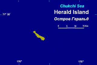
WHerald Island is a small, isolated Russian island in the Chukchi Sea, 70 km (43 mi) to the east of Waring Point, Wrangel Island. It rises in sheer cliffs, making it quite inaccessible, either by ship or by plane. The only bit of accessible shoreline is at its northwestern point, where the cliffs have crumbled into piles of loose rocks and gravel. Its area is 11.3 km2 (4.36 sq mi) and the maximum height above sea level is 364 m (1,194 ft). The island is unglaciated and uninhabited.
 W
WHjelmsøya is an island in Måsøy Municipality in Troms og Finnmark county, Norway. The 39-square-kilometre (15 sq mi) island lies west of the islands of Måsøya and Magerøya, north of Havøya and the mainland, and east of Ingøya. The mountainous island has been uninhabited since 1967. There are connections to the island other than by private boats.
 W
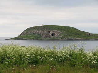
WHornøya is a small, 0.4 square kilometres, uninhabited island in Vardø Municipality in Troms og Finnmark county, Norway. It lies in the Barents Sea, just east of the larger island of Vardøya where the town of Vardø is located. Vardø Lighthouse is situated at the highest point of the island, at an elevation of 65 metres (213 ft) above sea level, and it protects the shipping lanes around the town of Vardø. The island is the easternmost point of Norway proper.
 W
WJan Mayen is a Norwegian volcanic island in the Arctic Ocean, with no permanent population. It is 55 km (34 mi) long (southwest-northeast) and 373 km2 (144 sq mi) in area, partly covered by glaciers [an area of 114.2 km2 (44.1 sq mi) around the Beerenberg volcano. It has two parts: larger northeast Nord-Jan and smaller Sør-Jan, linked by a 2.5 km (1.6 mi) wide isthmus. It lies 600 km (370 mi) northeast of Iceland, 500 km (310 mi) east of central Greenland and 1,000 km (620 mi) west of the North Cape, Norway. The island is mountainous, the highest summit being the Beerenberg volcano in the north. The isthmus is the location of the two largest lakes of the island, Sørlaguna, and Nordlaguna. A third lake is called Ullerenglaguna. Jan Mayen was formed by the Jan Mayen hotspot.
 W
WKiatak or Northumberland Island, also known as Kujata, is an island off the coast of northern Greenland.
 W
WLangøya is the third largest island of Norway, with an area of 850.2 square kilometres (328.3 sq mi). The island is a part of the Vesterålen archipelago in Nordland county, Norway. The island includes the municipalities of Bø and Øksnes as well as parts of the municipalities of Sortland and Hadsel.
WLille Kamøya is a small island in Nordkapp Municipality in Troms og Finnmark county, Norway. It is located just off the eastern coast of the large island of Magerøya. It lies where the Duksfjorden meets the Kamøyfjorden, just to the northwest of the island of Store Kamøya and to the north of the fishing village of Kamøyvær. The island helps to shelter Kamøyvær's harbour from the open sea.
 W
WLofoten is an archipelago and a traditional district in the county of Nordland, Norway. Lofoten has distinctive scenery with dramatic mountains and peaks, open sea and sheltered bays, beaches and untouched lands. There are two towns, Svolvær and Leknes - the latter is approximately 169 km (105 mi) north of the Arctic Circle and approximately 2,420 km (1,500 mi) away from the North Pole. The archipelago experiences one of the world's largest elevated temperature anomalies relative to its high latitude.
 W
WLoppa, is an island in Loppa Municipality in Troms og Finnmark county, Norway. The 12-square-kilometre (4.6 sq mi) island lies in the Lopphavet Sea in the western part of the municipality, west of the island of Silda. The small island has one village area on the southeastern coast. This village used to be the administrative centre of Loppa and an important fishing village for the municipality, but all of the administration of the village was moved to Øksfjord on the mainland. Today, Loppa Church is still located in this village, but there are only a few residents remaining on the island.
 W
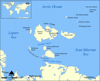
WThe New Siberian Islands are an archipelago in the Extreme North of Russia, to the North of the East Siberian coast between the Laptev Sea and the East Siberian Sea north of the Sakha (Yakutia) Republic.
 W
WNiaqunnguut (Inuktitut syllabics: ᓂᐊᖁᙴᑦ formerly Cape Graham Moore, after Vice-Admiral Sir Graham Moore, is an uninhabited headland on Bylot Island in the Qikiqtaaluk Region of Nunavut, Canada. It is located at the island's southeastern tip protruding into Lancaster Sound. The community of Pond Inlet is 70 km to the southwest.
 W
WNord-Fugløya or Fugløya is an uninhabited island in Karlsøy Municipality in Troms og Finnmark, Norway. The highest mountain is the 750-metre (2,460 ft) tall Fugløykallen. Fugløykalven Lighthouse is located north of the island.
 W
WNorth Kent Island is one of the uninhabited Canadian arctic islands in the Qikiqtaaluk Region of Nunavut, Canada. It is located in the Cardigan Strait between Devon Island's Colin Archer Peninsula and Ellesmere Island's Simmons Peninsula.
WNuvuttiq (ᓄᕗᑦᑎᖅ) formerly Cape Searle is an uninhabited headland located on Qaqaluit Island's northeastern tip, in the Qikiqtaaluk Region of Nunavut, Canada.
 W
WØksnes is a municipality in Nordland county, Norway. It is located on the northwestern part of the large island of Langøya, which is a part of the traditional region of Vesterålen. The administrative centre of the municipality is the village of Myre. Other villages in Øksnes include Alsvåg, Barkestad, Breidstrand, Nyksund, Strengelvåg, and Stø.
 W
WPrince Leopold Island is an island in the Qikiqtaaluk Region of Nunavut, Canada. It is located in Lancaster Sound at the junction of Prince Regent Inlet and Barrow Strait. Somerset Island is situated 13 km (8.1 mi) to the southwest; Port Leopold, an abandoned trading post, is the closest landmark. The island is significant as a summer habitat and breeding ground for large populations of several arctic bird species.
 W
WThe Prince Leopold Island Migratory Bird Sanctuary is a migratory bird sanctuary in Qikiqtaaluk, Nunavut, Canada. It is located on Prince Leopold Island within Lancaster Sound at the junction of Prince Regent Inlet and Barrow Strait. It was established in 1992 and is classified Category IV by the International Union for Conservation of Nature. It is 31,100 hectares in size, and has a flat, rocky surface with vertical exposed sedimentary rock cliffs nearly all the way around the island.
 W
WQikiqtaryuaq, formerly Jenny Lind Island, for the Swedish born opera singer, Jenny Lind, is a small island 420 km2 (160 sq mi) in the Kitikmeot Region of Nunavut, Canada. The island is located in the Queen Maud Gulf, about 120 km (75 mi) southeast of Cambridge Bay.
WReid Bay is an Arctic waterway in the Qikiqtaaluk Region, Nunavut, Canada. It is located in Davis Strait off Baffin Island's Cumberland Sound.
 W
WReinøya is an island in the municipality of Vardø in Troms og Finnmark, Norway. It is located west of Hornøya. Reinøya has a rich birdlife.
 W
WRøst is a small island municipality in Nordland county, Norway. It is part of the traditional district of Lofoten. The administrative centre of the municipality is the village of Røstlandet on the island of Røstlandet.
WSaunders Island is an island in North Star Bay, Baffin Bay in the Qaasuitsup municipality of northwest Greenland. The island is named after Commander James Saunders of the British Royal Navy.
WSeymour Island is an uninhabited island in the Qikiqtaaluk Region of northern Canada's territory of Nunavut. A member of the Berkeley Islands group, it is located approximately 30 mi (48 km) north of northern Bathurst Island. Between Seymour Island and Bathurst Island lies Helena Island. Penny Strait lies about 90 km (56 mi) to the east where open water polynyas occur.
WVærøya or Værøy is an island in Værøy Municipality in Nordland county, Norway. The 15.7-square-kilometre (6.1 sq mi) island makes up about 89% of the land area of the whole municipality and it is home to 100% of the municipal residents.
 W
WWrangel Island is an island of the Chukotka Autonomous Okrug, Russia. Located in the Arctic Ocean between the Chukchi Sea and East Siberian Sea, the island lies astride the 180th meridian. The International Date Line is therefore displaced eastwards at this latitude to avoid the island as well as the Chukchi Peninsula on the Russian mainland to keep the island on the same day as the rest of Russia. The closest land to Wrangel Island is the tiny and rocky Herald Island located 60 km (37 mi) to the east. Wrangel Island is the last known place where woolly mammoths survived, until around 4,000 years ago.