 W
WThe Anglesey Coastal Path is a 200-kilometre (124 mi) long-distance footpath around the island of Anglesey in North Wales. The route is part of the Wales Coast Path.
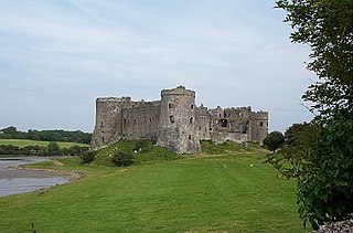
The Beacons Way is a waymarked long distance footpath in the Brecon Beacons National Park, Wales. It is a linear route which runs for 99 miles (159 km) east to west through the National Park, and passes many of the most important landmarks and mountain peaks in the mountain range. It also includes a few of the towns in the park as well as popular attractions such as Carreg Cennen Castle near Llandeilo at the western end of the path.
 W
WThe Cambrian Way, initially an unofficial long distance footpath in Wales running from Cardiff to Conwy, was officially recognised in 2019. Primarily a mountain walk, it runs over many of the highest and most scenically beautiful areas of Wales. It was pioneered in the 1960s and 1970s by walker Tony Drake, who later produced a guidebook of the walk.
 W
WThe Cardiff Centenary Walk is a tourist walkway through Cardiff city centre in Wales. Established as part of Cardiff's centennial celebrations to mark 100 years of city status in 2005, it has 41 points of interest, either Cardiff landmarks or significant historic sites. The route is marked by waymarkers on the pavement, which also direct pedestrians to the next waymarker. The whole walk is 3.6 kilometres (2.2 mi) long running around Cardiff in a clockwise direction, starting and finishing at the Cardiff Visitor Centre at the Old Library.
 W
WThe Ceredigion Coast Path is a waymarked long distance footpath in the United Kingdom, on the coast of Ceredigion, Wales. It is 65 miles (105 km) in length, running along the coast of Cardigan Bay from Cardigan (52.0810°N 4.6608°W) to Ynyslas (52.5271°N 4.0495°W).
 W
WThe Cistercian Way is a waymarked, long-distance trail which circumnavigates Wales, linking the Cistercian historic sites of Wales. It is a circular walk and can be started from any point along its route. The total length is approximately 650 miles (1,050 km).
 W
WThe Clywedog Trail is a 9-mile (14 km) footpath close to Wrexham in Wales. Starting at the Minera Lead Mines (53.0512°N 3.0811°W) and running to King's Mills (53.0358°N 2.9750°W), it follows the course of the River Clywedog. It is a haven for walking, relaxation and enjoying the peace of the wildlife. It is said that the Clywedog Valley was the Silicon Valley of the 18th century, as it was there that British ironmaking began in 1670, smelting iron ore with coke began in 1721 and John Wilkinson set up shop in 1761. For many years the area was one of the most important iron manufacturing centers in the world.
 W
WThe Epynt Way is a long-distance path created by the Ministry of Defence in 2004 around the perimeter of its 'Sennybridge Training Area (SENTA)' and artillery range on Mynydd Epynt in Powys, Wales. There is, understandably, virtually no public access across the land used by the MoD, pre-existing public rights of way and public roads having been closed, with only one or two exceptions. The establishment of the Epynt Way, section by section in recent years has gone some way to compensating for that reduction in public access across the area.
 W
WGlyndŵr's Way is a long-distance footpath in mid Wales. It runs for 135 miles (217 km) in an extended loop through Powys between Knighton and Welshpool, and anchored on Machynlleth to the west.
 W
WThe Gower and Swansea Bay Coast Path is part of the Wales Coast Path, an 1,400-kilometre (870 mi) long-distance walking route around the whole coast of Wales that opened in 2012. The Gower and Swansea Bay stretch is 156 kilometres (97 mi) in length, running along the coast of the Gower Peninsula from Loughor, Swansea to Kenfig Dunes near Port Talbot, South Wales. The number of people using the Wales Coast Path in the Swansea local authority area was 349,333.
 W
WThe Landsker Borderlands Trail is a waymarked long distance footpath in the United Kingdom running through Pembrokeshire and Carmarthenshire in West Wales. The route is circular.
WThe Llŷn Coastal Path is a waymarked 146-kilometre (91 mi) long-distance footpath running along the coast of the Llŷn Peninsula from Caernarfon to Porthmadog in Gwynedd, north-west Wales. A large part of the Llŷn Peninsula is designated an Area of Outstanding Natural Beauty.
 W
WLôn Goed is a rural lane in Efionydd, Gwynedd. Many Welsh writers have referred to it, e.g. the poet R. Williams Parry. It is named after the two rows of trees either side of the lane.
 W
WMaelor Way is a key long distance footpath, running 38 kilometres / 24 miles from the Offa's Dyke Path National Trail at Bronygarth to the Shropshire Way, Sandstone Trail, Llangollen Canal, South Cheshire Way, and the Marches Way all at Grindley Brook near Whitchurch.
 W
WThe Marches Way is a partially waymarked long distance footpath in the United Kingdom. It runs 351 kilometres / 218 miles through the Welsh–English borderlands, traditionally known as the Welsh Marches and links the cities of Chester in the north and Cardiff in the south.
 W
WThe Millennium Coastal Path is a 13 miles (21 km) pedestrian walkway and cycleway along the south coast of Carmarthenshire, providing a link between Llanelli and Pembrey Country Park. The cycleway forms a section of both the Celtic Trail cycle route and the National Cycle Network NCN 4.
 W
WMonnow Valley Walk is a 40 miles (64 km) long-distance footpath in north-east Monmouthshire, South Wales, with short sections in Herefordshire, England and Powys. It links Monmouth and Hay-on-Wye, following the River Monnow and the foot of the Black Mountains. The trail is linear running through the valley of the River Monnow, from Monmouth, near its confluence with the River Wye, to the headwaters below Hay Bluff. At this point, the walk links up with the Offa's Dyke Path National Trail, sharing the same route to the finishing points at Hay-on-Wye.
WThe North Wales Path is a long-distance walk of some 60 miles (97 km) that runs close to the coast of northern Wales between Prestatyn in the east and Bangor in the west. Parts of it overlap with the Wales Coast Path. The path runs along parts of the Clwydian Range Area of Outstanding Natural Beauty (AONB). The path was devised, implemented and maintained by the then Countryside Council for Wales and three councils: Gwynedd, Conwy, and Denbighshire.
 W
WOffa's Dyke Path is a long-distance footpath broadly following the Wales–England border. Officially opened on 10 July 1971, by Lord Hunt, it is one of Britain's National Trails and draws walkers from throughout the world. About 60 miles (97 km) of the 177-mile (285 km) route either follows, or keeps close company with, the remnants of Offa's Dyke, an earthwork, most of which was probably constructed in the late 8th century on the orders of King Offa of Mercia.
 W
WThe Pembrokeshire Coast Path, often called the Pembrokeshire Coastal Path, is a designated National Trail in Pembrokeshire, southwest Wales. Established in 1970, it is a 186-mile (299 km) long-distance walking route, mostly at cliff-top level, with a total of 35,000 feet (11,000 m) of ascent and descent. At its highest point – Pen yr afr, on Cemaes Head – it reaches a height of 574 feet (175 m), and at its lowest point – Sandy Haven crossing, near Milford Haven – it is just 6 feet (2 m) above low water. Whilst most of the coastline faces west, it offers – at varying points – coastal views in every direction of the compass.
 W
WSaint Illtyd's Walk is a 64-mile-long (103 km) waymarked long-distance footpath in South Wales. It runs from Pembrey Country Park, west of Burry Port, through rural eastern Carmarthenshire and Neath Port Talbot to end at Margam Country Park, south of Port Talbot.
 W
WThe South Wales Coast and Severn Estuary Coastal Path covers Region H of the larger Wales Coast Path, an 870-mile (1,400 km) long-distance walking route around the whole coast of Wales which opened on 5 May 2012. The South Wales Coast and Severn Estuary stretch is a 109-mile (176 km) in length running from Kenfig Dunes near Port Talbot, South Wales to Chepstow. With five local councils involved in its creation and maintenance, the route goes through a heritage coast, three national nature reserves and three heritage landscapes.
 W
WThe Taff Trail is a popular walking and cycle path that runs for 55 miles (89 km) between Cardiff Bay and Brecon in Wales. It is so named because it follows the course of the River Taff. Along much of its length, it follows the National Cycle Network Route 8 that continues to Holyhead, and is substantially off-road.
 W
WThe Three Castles Walk is a waymarked long distance footpath and recreational walk located in north-east Monmouthshire, Wales.
 W
WThe Valeways Millennium Heritage Trail is a waymarked long distance footpath in the Vale of Glamorgan, Wales.
 W
WThe Wye Valley Walk is a long distance footpath in Wales and England following the course of the River Wye.