 W
WThe Dane Valley Way is a long-distance footpath through Derbyshire, Staffordshire and Cheshire, England. It runs from the Pavilion Gardens in Buxton to the end of the River Dane, where it enters the River Weaver in Northwich.
 W
WThe E2 European long distance path or E2 path is a 4850 km (3010-mile) series of long-distance footpaths that is intended to run from Galway in Ireland to France's Mediterranean coast and currently runs through Northern Ireland, Scotland, England, Belgium, Luxembourg and France, with an alternative midsection equally designated via the Netherlands and east coast of England. It is one of the network of European long-distance paths.
 W
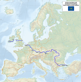
WThe E8 European long distance path or E8 path is one of the European long-distance paths, leading 4,700 km across Europe, from Cork in Ireland to Bulgaria.
 W
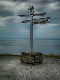
WLand's End to John o' Groats is the traversal of the whole length of the island of Great Britain between two extremities, in the southwest and northeast. The traditional distance by road is 874 miles (1,407 km) and takes most cyclists 10 to 14 days; the record for running the route is nine days. Off-road walkers typically walk about 1,200 miles (1,900 km) and take two or three months for the expedition. Signposts indicate the traditional distance at each end.Land's End is the traditionally acknowledged extreme southern point of mainland England. It is in western Cornwall at the end of the Penwith peninsula. The O.S. Grid Reference of the road end is SW342250, Postcode TR19 7AA. In fact it, or strictly speaking Dr Syntax's Head, SW341253, a few hundred yards NW of the road end, is mainland England's most westerly point. The most southerly point is Lizard Point, about 9 miles (14 km) further south. Land's End is sometimes reckoned incorrectly as mainland England's most southwesterly point. This accolade belongs to Gwennap Head, SW365215, which is at least 2 miles (3.2 km) further south than Dr Syntax's Head but only about 1.5 miles (2.4 km) less west. John o' Groats is the traditionally acknowledged extreme northern point of mainland Scotland, in northeastern Caithness, O.S. Grid Reference ND380735, Postcode KW1 4YR. The actual northernmost point is Dunnet Head about 2 miles (3 km) further north. The point that is farthest by road from Land's End is Duncansby Head, about 2 miles (3 km) east of John o' Groats. Duncansby Head is also the most northeasterly point of the Scottish mainland.
 W
WMaelor Way is a key long distance footpath, running 38 kilometres / 24 miles from the Offa's Dyke Path National Trail at Bronygarth to the Shropshire Way, Sandstone Trail, Llangollen Canal, South Cheshire Way, and the Marches Way all at Grindley Brook near Whitchurch.
 W
WThe Marches Way is a partially waymarked long distance footpath in the United Kingdom. It runs 351 kilometres / 218 miles through the Welsh–English borderlands, traditionally known as the Welsh Marches and links the cities of Chester in the north and Cardiff in the south.
 W
WOffa's Dyke Path is a long-distance footpath broadly following the Wales–England border. Officially opened on 10 July 1971, by Lord Hunt, it is one of Britain's National Trails and draws walkers from throughout the world. About 60 miles (97 km) of the 177-mile (285 km) route either follows, or keeps close company with, the remnants of Offa's Dyke, an earthwork, most of which was probably constructed in the late 8th century on the orders of King Offa of Mercia.
 W
WThe Orange Way, so called because it follows the march in 1688 of Prince William of Orange and his army from Brixham to London, is a 350 miles (560 km) unofficial long-distance walk in England that passes through Devon, Dorset, Wiltshire, Berkshire, Buckinghamshire and London.
 W
WThe Peak District Boundary Walk is a circular 190-mile (310 km) walking trail, starting and finishing at Buxton and broadly following the boundary of the Peak District, Britain's first national park. The route was developed by the Friends of the Peak District and was launched on 17 June 2017.
 W
WThe Pennine Way is a National Trail in England, with a small section in Scotland. The trail stretches for 268 miles (431 km) from Edale, in the northern Derbyshire Peak District, north through the Yorkshire Dales and Northumberland National Park and ends at Kirk Yetholm, just inside the Scottish border. The path runs along the Pennine hills, sometimes described as the "backbone of England". Although not the United Kingdom's longest National Trail, it is according to The Ramblers "one of Britain's best known and toughest".
 W
WThe Severn Way is a waymarked long-distance footpath in the United Kingdom, which follows the course of the River Severn through Mid Wales and western England.
 W
WSt Cuthbert's Way is a 100-kilometre (62 mi) long-distance trail between the Scottish Borders town of Melrose and Lindisfarne off the coast of Northumberland, England. The walk is named after Cuthbert, a 7th-century saint, a native of the Borders who spent his life in the service of the church. The route links Melrose Abbey, where Cuthbert began his religious life, with his initial burial place on Holy Island. Cuthbert achieved the status of bishop, and was called a saint eleven years after his death, when his coffin was opened and his remains found to be perfectly preserved.
 W
WThe Ulster Way is a series of walking routes which encircles Northern Ireland. It was founded in the 1970s by Wilfrid Merydith Capper, who was inspired by Tom Stephenson's Pennine Way. The route was relaunched in 2009 by the Department of the Environment.
 W
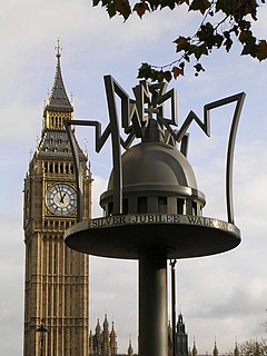
WWalking is a popular recreational activity in London, despite traffic congestion. There are many streets that provide interesting walks, especially within historic central London, In addition there are attractive commons, parks, canals, and disused railway tracks that provide space for walks. This includes Wimbledon Common, Epping Forest, Hampstead Heath, and the eight Royal Parks: Hyde Park, Regent's Park, Richmond Park, etc. In recent years access to canals and rivers, including the Regent's Canal, and the River Thames has been greatly improved, and as well a number of long-distance walking routes have been created that link green spaces.
 W
WThe Wye Valley Walk is a long distance footpath in Wales and England following the course of the River Wye.