 W
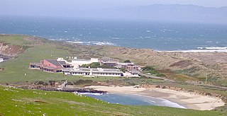
WBodega Marine Reserve is a 362-acre (146 ha) nature reserve and marine reserve on the coast of northern California, located in the vicinity of the Bodega Marine Laboratory on Bodega Head. It is a unit of the University of California Natural Reserve System, administered by the University of California, Davis.
 W
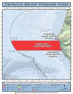
WThe South Cape Mendocino State Marine Reserve is an offshore marine protected area located off Cape Mendocino and the coastal town of Petrolia about 30 miles (48 km) south of Eureka. It marks California’s westernmost point. The area is one of the most undeveloped sections of the California coast, and its waters are homes to important bird and mammal species. Within the South Cape Mendocino State Marine Reserve, the take of all living marine resources is prohibited.
 W
WSugar Loaf Island, also known as Sugar Loaf, Cape Rock, Sugarloaf Island, Sugar Loaf Rock, and Sugarloaf Rock Island is an island offshore Cape Mendocino in Humboldt County, California. It is the westernmost island in California
 W
WEmeryville Crescent State Marine Reserve is a marine reserve of California, United States, preserving marshland on the east shore of San Francisco Bay. It is managed as part of Eastshore State Park by the East Bay Regional Park District. The 103.5-acre (41.9 ha) marsh stretches from the eastern approach of the San Francisco–Oakland Bay Bridge in Oakland to the foot of Powell Street in Emeryville. The reserve encompasses the entire Emeryville Crescent Marsh and is named as such for its crescent shape. It was established in 1985.
 W
WThe Experimental Oculina Research Reserve preserves the Oculina Banks, a reef of ivory bush coral off the coast of Fort Pierce, Florida. Oculina varicosa is a U.S. National Marine Fisheries Service species of concern. Species of concern are those species about which the U.S. Government's National Oceanic and Atmospheric Administration (NOAA), National Marine Fisheries Service, has some concerns regarding status and threats, but for which insufficient information is available to indicate a need to list the species under the U.S. Endangered Species Act (ESA).
 W
WGerstle Cove State Marine Reserve (SMR) is a marine protected area that lies onshore from Salt Point State Park, within the Salt Point State Marine Conservation Area, in Sonoma County on California’s north central coast. The marine protected area covers 0.1 square miles. Gerstle Cove SMR prohibits the take of all living resources.
 W
WThe Gulf of Maine has been fished since the 1700s, and has been a historic fishing area since. Climate change is having significant impacts on this ecosystem; between 2004 and 2013, the Gulf of Maine has warmed faster than 99.9% of the global oceans, increasing average temperature by 2 °C (3.6 °F). Having seen the depletion of groundfish stocks starting in the early 1990s, managers took care to create five closure areas in the Gulf of Maine.
 W
WMorro Bay State Marine Recreational Management Area (SMRMA) and Morro Bay State Marine Reserve (SMR) are two marine protected areas that provide protection for Morro Bay Estuary on California's central coast. The two marine protected areas together encompass 3.31 square miles (8.6 km2). Within the SMRMA, fishing and take of any living marine resources is prohibited except that north of latitude 35° 19.70′ N the recreational take of finfish and aquaculture of oysters, pursuant to a valid state water bottom lease and permit, is permitted. And recreational hunting of waterfowl is allowed unless otherwise restricted by hunting regulations. The SMR protects all marine life within its boundaries. Fishing and take of any living marine resources is prohibited.
 W
WThe Northeast Canyons and Seamounts Marine National Monument is a marine national monument of the United States off the coast of New England, on the seaward edge of Georges Bank. It was created by President Barack Obama on September 15, 2016 as the first U.S. marine national monument in the Atlantic Ocean.
 W
WThe Pacific Remote Islands Marine National Monument is a group of unorganized, mostly unincorporated United States Pacific Island territories managed by the United States Fish and Wildlife Service of the United States Department of the Interior and the National Oceanic and Atmospheric Administration (NOAA) of the United States Department of Commerce. These remote refuges are "the most widespread collection of marine- and terrestrial-life protected areas on the planet under a single country's jurisdiction". They protect many endemic species including corals, fish, shellfish, marine mammals, seabirds, water birds, land birds, insects, and vegetation not found elsewhere.
 W
WThe Papahānaumokuākea Marine National Monument is a World Heritage listed U.S. National Monument encompassing 583,000 square miles (1,510,000 km2) of ocean waters, including ten islands and atolls of the Northwestern Hawaiian Islands. Created in June 2006 with 140,000 square miles (360,000 km2), it was expanded in August 2016 by moving its border to the limit of the exclusive economic zone, making it one of the world's largest protected areas. It is internationally known for its cultural and natural values as follows: The area has deep cosmological and traditional significance for living Native Hawaiian culture, as an ancestral environment, as an embodiment of the Hawaiian concept of kinship between people and the natural world, and as the place where it is believed that life originates and to where the spirits return after death. On two of the islands, Nihoa and Mokumanamana, there are archaeological remains relating to pre-European settlement and use. Much of the monument is made up of pelagic and deepwater habitats, with notable features such as seamounts and submerged banks, extensive coral reefs and lagoons.
 W
WPiedras Blancas State Marine Reserve (SMR) and Piedras Blancas State Marine Conservation Area (SMCA) are two adjoining marine protected areas that lie offshore of San Luis Obispo County on California’s central coast. The combined area of these marine protected areas is 19.68 square miles (51.0 km2). The SMR protects all marine life within its boundaries. Fishing and take of all living marine resources is prohibited. Within the SMCA fishing and take of all living marine resources is prohibited except the commercial and recreational take of salmon and albacore.
 W
WPoint Sur State Marine Reserve (SMR) and Point Sur State Marine Conservation Area (SMCA) are two adjoining marine protected areas that lie offshore of Point Sur, part of the Big Sur area on California's central coast. The combined area of these marine protected areas is 19.68 square miles (51.0 km2). The SMR protects all marine life within its boundaries. Fishing and take of all living marine resources is prohibited. Within the SMCA fishing and take of all living marine resources is prohibited except the commercial and recreational take of salmon and albacore.