 W
WBaker Island is an uninhabited atoll just north of the equator in the central Pacific Ocean about 3,090 km (1,920 mi) southwest of Honolulu. The island lies almost halfway between Hawaii and Australia. Its nearest neighbor is Howland Island, 42 mi (68 km) to the north-northwest; both have been claimed as territories of the United States since 1857, though the United Kingdom considered them part of the British Empire between 1897 and 1936.
 W
WClipperton Island is an uninhabited 6 km2 (2.3 sq mi) coral atoll in the eastern Pacific Ocean off the coast of Central America. It is 10,677 km (6,634 mi) from Paris, France, 5,400 km (2,900 nmi) from Papeete, Tahiti, and 1,080 km (580 nmi) from Mexico. It is an overseas state private property of France, under direct authority of the Minister of Overseas France.
 W
WCocos Island is an island in the Pacific Ocean administered by Costa Rica, approximately 550 km southwest of the Costa Rican mainland. It constitutes the 11th of the 13 districts of Puntarenas Canton of the Province of Puntarenas. With an area of approximately 23.85 km2 (9.21 sq mi), the island is more or less rectangular in shape. It is the southernmost point on the North American continent if outer islands are included.
 W
WThe Desventuradas Islands is a group of four small islands located 850 kilometres (530 mi) off the coast of Chile, northwest of Santiago in the Pacific Ocean. They are considered part of Insular Chile.
 W
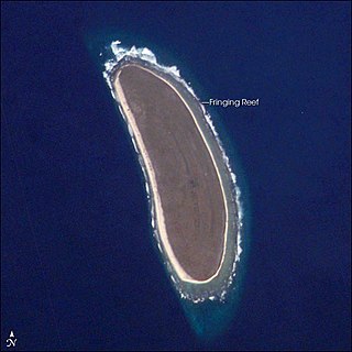
WHowland Island is an uninhabited coral island located just north of the equator in the central Pacific Ocean, about 1,700 nautical miles (3,100 km) southwest of Honolulu. The island lies almost halfway between Hawaii and Australia and is an unincorporated, unorganized territory of the United States. Together with Baker Island it forms part of the Phoenix Islands. For statistical purposes, Howland is grouped as one of the United States Minor Outlying Islands. The island has an elongated banana-shape on a north–south axis, 1.40 by 0.55 nautical miles, and covers 2.6 square kilometres.
 W
WMidway Atoll is a 2.4-square-mile (6.2 km2) atoll in the North Pacific Ocean at 28°12′N 177°21′W. Midway Atoll is an unorganized, unincorporated territory of the United States.
 W
WNorfolk Island is an external territory of Australia located in the Pacific Ocean between New Zealand and New Caledonia, 1,412 kilometres (877 mi) directly east of Australia's Evans Head and about 900 kilometres (560 mi) from Lord Howe Island. Together with the neighbouring Phillip Island and Nepean Island, the three islands collectively form the Territory of Norfolk Island. At the 2016 census, it had 1748 inhabitants living on a total area of about 35 km2 (14 sq mi). Its capital is Kingston.
 W
WThe Northwestern Hawaiian Islands or Leeward Islands are the small islands and atolls in the Hawaiian island chain located northwest of the islands of Kauai and Niihau. Politically, they are all part of Honolulu County in the U.S. state of Hawaii, except Midway Atoll, which is a territory distinct from Hawaii and grouped as one of the United States Minor Outlying Islands. The United States Census Bureau defines this area, except Midway, as Census Tract 114.98 of Honolulu County. Its total land area is 3.1075 square miles (8.048 km2). All the islands except Nihoa are north of the Tropic of Cancer, making them the only islands in Hawaii that lie outside the tropics.
 W
WPhillip Island is an island located 6 km (3.7 mi) south of Norfolk Island in the Southwest Pacific, and is part of the Norfolk Island group. It was named in 1788 by Lieutenant Philip Gidley King after Arthur Phillip, the first Governor of New South Wales. Phillip Island is part of the Australian external territory of Norfolk Island, and is included in Norfolk Island National Park, as is neighbouring Nepean Island and about 10 percent of Norfolk Island proper.
 W
WRapa, sometimes called Rapa Iti, or "Little Rapa," to distinguish it from Rapa Nui, or Big Rapa, is the largest and only inhabited island of the Bass Islands in French Polynesia. An older name for the island is Oparo. The total land area including offshore islets is 40.5 km2 (15.6 sq mi). As of the 2017 census, Rapa had a population of 507. The island's highest point is at 650 metres (2,130 ft) elevation at Mont Perahu. Its main town is Ahuréi. The inhabitants of Rapa Iti speak their own Polynesian language called the Rapa language.