 W
WRoyal Air Force Acaste Malbis or more simply RAF Acaster Malbis is a former Royal Air Force station located 5.9 miles (9.5 km) south of York city centre and 5.7 miles (9.2 km) east of Tadcaster, North Yorkshire, England. It was developed from a small grass airfield at the beginning of the Second World War and its main use was as a training base for RAF Bomber Command before being used by RAF Maintenance Command from 1944 until 1957.
 W
WRoyal Air Force Bawtry or more simply RAF Bawtry is a former Royal Air Force station located at Bawtry Hall in Bawtry, South Yorkshire, England and was No. 1 Group RAF Bomber Command headquarters and administration unit during and following the Second World War.
 W
WRoyal Air Force Bempton or more simply RAF Bempton is a former Royal Air Force station situated at Bempton in the East Riding of Yorkshire, England, 6 miles (10 km) north of Bridlington. During the Second World War it was established as a radar station, becoming part of the Chain Home Low (CHL) network.
 W
WRoyal Air Force Bircotes or more simply RAF Bircotes is a former Royal Air Force satellite airfield located within South Yorkshire and the Metropolitan Borough of Doncaster and was formerly located within the boundary of Nottinghamshire.
 W
WBreighton Aerodrome is a private aerodrome primarily used for General Aviation flying located on the former Royal Air Force Breighton or more simply RAF Breighton is a former Royal Air Force station located near to the village of Breighton, East Riding of Yorkshire, England.
 W
WRoyal Air Force Bridlington, or more simply RAF Bridlington, was a Royal Air Force station located in Bridlington, East Riding of Yorkshire, England, between 1929 and 1978. Several units operated at Bridlington, Air Gunnery Schools, Initial Training Wings, and an Air Sea Rescue launch unit, but the longest occupier, was No. 1104 Marine Craft Unit (MCU). The station consisted of various buildings across the town that were requisitioned for RAF use before and during the Second World War. Outside of this time, the RAF presence was mostly in the harbour area and as it was such a small unit, No. 1104 MCU was looked after by other RAF Stations nearby.
 W
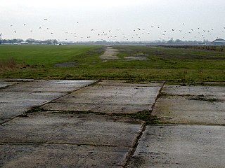
WRoyal Air Force Burn or more simply RAF Burn is a former Royal Air Force station located 5 miles (8 km) south of Selby and 0.5 miles (0.80 km) east of Burn in North Yorkshire, England which opened in 1942 before closing in 1946.
 W
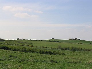
WRoyal Air Force Carnaby or more simply RAF Carnaby is a former Royal Air Force emergency landing strip that offered crippled bombers a safe place to land near the English coast during the Second World War. It was situated 2 miles (3.2 km) south-west of Bridlington, East Riding of Yorkshire.
WRoyal Air Force Catfoss or more simply RAF Catfoss is a former Royal Air Force station during the Second World War. It was located 4 miles (6.4 km) west of Hornsea, Yorkshire, England and 8 miles (13 km) north-east of Leconfield, Yorkshire, with the nearest village being Brandesburton.
 W
WRoyal Air Force Catterick or RAF Catterick is a former Royal Air Force airfield located near Catterick, North Yorkshire in England. It is located alongside the A6055 road on the outskirts of Catterick Village.
 W
WRoyal Air Force Church Fenton or RAF Church Fenton was a former Royal Air Force (RAF) station located 4.3 miles (6.9 km) south east of Tadcaster, North Yorkshire, England and 6.3 miles (10.1 km) north west of Selby, North Yorkshire, near the village of Church Fenton. The station was opened in 1937 and during the Second World War was home to air defence aircraft, a role retained by the station until the 1960s when it became a training station. It closed in 2013 and is now a civilian airfield known as Leeds East Airport.
WRoyal Air Force Clifton or RAF Clifton is a former Royal Air Force station located 1.5 miles (2.4 km) north west of York city centre and 2.6 miles (4.2 km) south west of Haxby, North Yorkshire, England.
 W
WRoyal Air Force Cottam or more simply RAF Cottam is a former Royal Air Force satellite airfield near Cottam in the East Riding of Yorkshire, England and 3.9 miles (6.3 km) north west of Driffield, East Riding of Yorkshire.
 W
WRoyal Air Force Croft or more simply RAF Croft is a former Royal Air Force station located 4.6 miles (7.4 km) south of Darlington, County Durham, England and 8 miles (13 km) north east of Richmond, North Yorkshire. The site is also known locally as Croft Aerodrome or Neasham. Constructed at the same time as many other airfields, it was originally named RAF Dalton-on-Tees after the nearby village Dalton-on-Tees. However, it was quickly renamed RAF Croft after initial confusion with the also newly opened RAF Dalton near Thirsk, just 25 miles away.
WRoyal Air Force Dalton or more simply RAF Dalton is a former Royal Air Force satellite station located near to Dalton, North Yorkshire, England.
WRoyal Air Force Danby Beacon or more simply RAF Danby Beacon was an early warning radar Royal Air Force station that formed part of the Chain Home network of radar stations built by the Royal Air Force immediately prior to the Second World War.
 W
WRoyal Air Force Dishforth or RAF Dishforth is a former Royal Air Force station located 4.4 miles (7.1 km) east of Ripon, North Yorkshire and 11.5 miles (18.5 km) north east of Harrogate, North Yorkshire, England.
WRoyal Air Force Doncaster or more simply RAF Doncaster, also referred to as Doncaster Aerodrome, is a former Royal Air Force station near Doncaster, South Yorkshire, England.
 W
WRoyal Air Force Driffield or RAF Driffield is a former Royal Air Force station in the East Riding of Yorkshire, in England. It lies about 2 miles (3 km) south-west of Driffield and 11 miles (18 km) north-west of Beverley.
 W
WRoyal Air Force East Moor or RAF East Moor is a former Royal Air Force station located 7.4 miles (11.9 km) north of York, North Yorkshire and 5.5 miles (8.9 km) south east of Easingwold, North Yorkshire, England.
 W
WRoyal Air Force Elvington or more simply RAF Elvington is a former Royal Air Force station which operated from the beginning of the Second World War until 1992 located at Elvington, Yorkshire, England.
 W
WRoyal Air Force Finningley or RAF Finningley was a Royal Flying Corps and Royal Air Force station at Finningley, in the Metropolitan Borough of Doncaster, South Yorkshire, England. The station straddled the historic county boundaries of both Nottinghamshire and the West Riding of Yorkshire.
WRoyal Air Force Firbeck or more simply RAF Firbeck is a former Royal Air Force station located west of Firbeck, South Yorkshire, England.
WRoyal Air Force Full Sutton or RAF Full Sutton is a former Royal Air Force station located 2.0 miles (3.2 km) south east of Stamford Bridge, East Riding of Yorkshire and 4.7 miles (7.6 km) north west of Pocklington, East Riding of Yorkshire, England.
 W
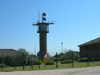
WRoyal Air Force Fylingdales or more simply RAF Fylingdales is a Royal Air Force station on Snod Hill in the North York Moors, England. Its motto is "Vigilamus". It is a radar base and is also part of the Ballistic Missile Early Warning System (BMEWS). As part of intelligence-sharing arrangements between the United States and United Kingdom, data collected at RAF Fylingdales are shared between the two countries. Its primary purpose is to give the British and US governments warning of an impending ballistic missile attack. A secondary role is the detection and tracking of orbiting objects; Fylingdales is part of the United States Space Surveillance Network. As well as its early-warning and space-tracking roles, Fylingdales has a third function - the Satellite Warning Service for the UK. It keeps track of spy satellites used by other countries, so that secret activities in the UK can be carried out when they are not overhead. The armed services, defence manufacturers and research organisations, including universities, take advantage of this facility.
 W
WRoyal Air Force Goldsborough or more simply RAF Goldsborough is a former Royal Air Force station located in North Yorkshire, England.
WRoyal Air Force Harrogate or RAF Harrogate, sometimes known as Ministry of Defence (MoD) Harrogate, was the name for two distinct Royal Air Force establishments within the town of Harrogate, North Yorkshire, England. The main site was at St George's in the south-west of the town and was home to a medical training establishment (MTE), supply branch and Women's Auxiliary Air Force (WAAF) training centre. The site was demolished in 1994. The term RAF Harrogate was also applied to the requisition of several hotels in Harrogate town centre which acted as a No. 7 Personnel Reception Centre during World War II. This should not be confused with RAF Menwith Hill, a current RAF base near Harrogate.
 W
WHedon Aerodrome, was an airfield located 6 miles (9.7 km) east of Kingston upon Hull in the East Riding of Yorkshire, England. The airfield was in operation intermittently between 1912 and the late 1950s both in a civilian and a military capacity. It was rejected as a Second World War airfield due to its proximity to the Salt End chemical works and oil tanks.
 W
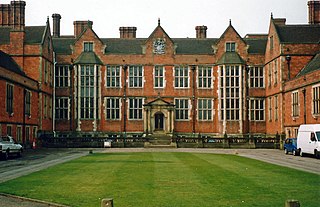
WHeslington Hall is a Grade II* listed rebuilt manor house near the village of Heslington, North Yorkshire, England, within the city of York. The hall is part of the campus of the University of York.
WRAF Holme-on-Spalding Moor, or more simply RAF Holme is a former Royal Air Force station located in the East Riding of Yorkshire, England.
 W
WRoyal Air Force Holmpton or more simply RAF Holmpton is a former Royal Air Force Cold War era nuclear bunker that was built in the 1950s as an early warning radar station as part of the ROTOR Radar Defence Programme. Located just south of the village of Holmpton, in the East Riding of Yorkshire, England, RAF Holmpton remained a part of the Defence Estate right up to 8 December 2014 when it was sold into private ownership after 62 years of military service.
 W
WRNAS Howden was an airship station near the town of Howden 15 miles (24 km) south-east of York, England.
 W
WRoyal Air Force Hutton Cranswick or more simply RAF Hutton Cranswick is a former Royal Air Force station located to the south of Driffield and immediately south west of the village of Hutton Cranswick in the East Riding of Yorkshire, England, opened in 1942 and closed in 1946.
 W
WRoyal Air Force Leconfield or more simply RAF Leconfield is a former Royal Air Force station located in Leconfield, East Riding of Yorkshire, England.
 W
WRoyal Air Force Leeming or RAF Leeming is a Royal Air Force station located near Leeming, North Yorkshire, England. It was opened in 1940 and was jointly used by the RAF and the Royal Canadian Air Force (RCAF). Between 1950 and 1991, it operated mostly as a training base with Quick Reaction Force (QRF) Tornado F3 fighters based there in the latter stages of the Cold War and into the early 21st century. Since 2006, it has become the home of the deployable RAF communications cadre and the home of No. 135 Expeditionary Air Wing.
 W
WRoyal Air Force Station Lindholme or more simply RAF Lindholme is a former Royal Air Force station in South Yorkshire, England. It is located 3.9 miles (6.3 km) south of Thorne and 6.9 miles (11.1 km) north east of Doncaster and was initially called RAF Hatfield Woodhouse.
 W
WRAF Linton-on-Ouse is a Royal Air Force station at Linton-on-Ouse in North Yorkshire, England, 10 miles (16 km) north-west of York. It has satellite stations at RAF Topcliffe and Dishforth Airfield.
WRoyal Air Force Station Lissett or more simply RAF Lissett is a former Royal Air Force station located 6.1 miles (9.8 km) south west of Bridlington, East Riding of Yorkshire, England.
 W
WRoyal Air Force Manywells Height was a grassed airstrip in use as Home Defence during the First World War. The site was just south of the village of Cullingworth which is south of Keighley and north west of Bradford in West Yorkshire.
 W
WRAF Marston Moor was a Royal Air Force airfield at Tockwith, North Yorkshire, during the Second World War. It was originally called RAF Tockwith, but confusion with RAF Topcliffe led to the name change.
 W
WRoyal Air Force Melbourne or more simply RAF Melbourne is a former Royal Air Force station used during the Second World War. Located 5 miles to the south-west of Pocklington, Yorkshire, England. The nearest village is Seaton Ross.
 W
WRoyal Air Force Menwith Hill is a Royal Air Force station near Harrogate, North Yorkshire, England, which provides communications and intelligence support services to the United Kingdom and the United States. The site contains an extensive satellite ground station and is a communications intercept and missile warning site. It has been described as the largest electronic monitoring station in the world.
 W
WRAF Oxenhope Moor was a British Second World War radio station, located on Cock Hill Moor near the village of Oxenhope in Yorkshire. It was known by a number of different names, including Oxenhope Laboratory, Oxenhope Radar Station and Oxenhope Weather Station.
 W
WRAF Pocklington was an operational flying station of the Royal Air Force during the Second World War, forming part of Bomber Command, and operating primarily Wellington and Halifax bombers. The station, adjacent to the town of Pocklington at grid reference SE790485, opened in 1941, and was closed in 1946. After a return to agricultural use, the station now forms an industrial estate and a restricted use airfield for a gliding club.
WRAF Riccall is a former Royal Air Force airfield located 3.1 miles (5 km) north east of Selby, North Yorkshire and 7.9 miles (12.7 km) south west of Elvington, North Yorkshire, England.
 W
WRoyal Air Force Ripon was a First World War airfield maintained by the Royal Flying Corps in the city of Ripon, North Yorkshire, England. The airfield was home to No. 76 Squadron which was employed on Home Defence (HD) in the United Kingdom. The airfield was created when the Royal Flying Corps (RFC) commandeered the southern half of Ripon Racecourse in 1916. After the end of the First World War, the airfield was returned to horse-racing.
 W
WRoyal Air Force Rufforth or RAF Rufforth is a former Royal Air Force station located near Rufforth in North Yorkshire, England.
 W
WRAF Scorton was opened in October 1939 as part of 13 Group Fighter Command and a satellite station of RAF Catterick. It was located near the village of Scorton in North Yorkshire, England. It was used by the Royal Air Force, the Royal Canadian Air Force, and the United States Army Air Forces Ninth Air Force during the war.
 W
WRoyal Air Force Shipton, was a First World War era airfield located north of the village of Shipton-by-Beningbrough, in North Yorkshire, England. During the First World War, it was used by No. 76 Squadron RAF whose remit was to provide Home Defence (HD).
 W
WRoyal Air Force station Skipton-on-Swale or more simply RAF Skipton-on-Swale is a former Royal Air Force station operated by RAF Bomber Command during the Second World War. The station was located at Skipton-on-Swale 4 miles (6.4 km) west of Thirsk, North Yorkshire, England. The village of Sandhutton is located just to the east. RAF Skipton-on-Swale was a sub-station of RAF Leeming.
 W
WRoyal Air Force Snaith or RAF Snaith is a former Royal Air Force station which was located 7 miles (11 km) south west of Goole, Yorkshire, England and close to the village of Pollington.
 W
WRemote Radar Head Staxton Wold or RRH Staxton Wold is an air defence radar station operated by the Royal Air Force, located near Scarborough in North Yorkshire, England.
 W
WRoyal Air Force Sutton on Hull or more simply RAF Sutton on Hull was a Royal Air Force station situated in the suburb of Sutton-on-Hull in the East Riding of Yorkshire that operated from 1938 to 1961. During the Second World War, its primary role was to operate as No. 17 Balloon Centre of 33 Group which was headquartered in Sheffield. The balloons deployed from here were used as part of the defensive tactics against Luftwaffe bombing raids on Hull, Hull Docks, Grimsby and the wider Humber area.
 W
WRAF Tholthorpe was a Royal Air Force air station operated by RAF Bomber Command during the Second World War. The station, which had been opened in the late 1930s as a grass airfield, was located near Easingwold, North Yorkshire, UK. Tholthorpe airfield operated as a sub-station of RAF Linton-on-Ouse.
WRoyal Air Force Thornaby or more simply RAF Thornaby was a former Royal Air Force Station located in the town and Borough of Thornaby-on-Tees, North Yorkshire, England. Fighter Command, Bomber Command and Coastal Command all operated from the base over its history, but its stint under Coastal Command is what the base was notable for, particularly in the air-sea rescue environment and the development of the Thornaby Bag. This was an emergency bag dropped to downed aircrew at sea and contained food, cigarettes and drink.
 W
WRoyal Air Force Topcliffe or RAF Topcliffe is a Royal Air Force station in North Yorkshire, England. It is home to No. 645 Volunteer Gliding Squadron flying the Grob Viking T.1 glider.
 W
WRoyal Air Force Station Wombleton or RAF Wombleton is a former Royal Air Force station located 3.8 miles (6.1 km) east of Helmsley, North Yorkshire and 11.8 miles (19 km) north east of Easingwold, North Yorkshire, England.