 W
WThe United States Army Corps of Engineers (USACE) is an engineer formation of the United States Army that has three primary mission areas: engineer regiment, military construction, and civil works. The day-to-day activities of the three mission areas are administered by a lieutenant general known as the commanding general/chief of engineers. The chief of engineers commands the engineer regiment, composed of combat engineer army units, and answers directly to the chief of staff of the army. Combat engineers come from throughout the service and can be active duty, national guard, or army reserve. Combat engineers duties are to construct fighting positions, fixed/floating bridges, and obstacles and defensive positions, place and detonate explosives (sappers), conduct operations that include route clearance of obstacles and rivers, prepare and install firing systems for demolition and explosives, and detect mines. For the military construction mission the commanding general is directed and supervised by the assistant secretary of the army for installations, environment, and energy, whom the President appoints and the Senate confirms. Military construction relates to construction on military bases and worldwide installations.
 W
WThe 249th Engineer Battalion is a versatile power generation battalion assigned to the U.S. Army Corps of Engineers that provides commercial-level power to military units and federal relief organizations during full-spectrum operations. Additionally, the commander serves as the Commandant of the U.S. Army Prime Power School, the institution responsible for the development of Army and Navy power generation specialists.
The 1269th Engineer Combat Battalion was an engineer combat battalion that served in the United States Army in the European Theater of Operations during World War II. It saw action in France and Germany, serving notably with the Army's T-Force intelligence assault force in the capture of German atomic weapons facilities and personnel as part of Operation Big.
 W
WArmy engineer divers are members of national armies who are trained to undertake reconnaissance, demolition, and salvage tasks underwater. These divers have similar skills and qualifications as professional divers. In the United States Army, they are members of the Corps of Engineers. In the British Army they may be Royal Engineers Divers or Commando Engineer Divers.
The Army Geospatial Center (AGC) is a Major Subordinate Command of the United States Army Corps of Engineers. It is located in Alexandria, Virginia, within the Humphreys Engineering Center adjacent to the Fort Belvoir military reservation.
The Army Map Service (AMS) was the military cartographic agency of the United States Department of Defense from 1941 to 1968, subordinated to the United States Army Corps of Engineers. On September 1, 1968, the AMS was redesignated the U.S. Army Topographic Command (USATC) and continued as an independent organization until January 1, 1972, when it was merged into the new Defense Mapping Agency (DMA) and redesignated as the DMA Topographic Center (DMATC). On October 1, 1996, DMA was folded into the National Imagery and Mapping Agency (NIMA), which was redesignated as the National Geospatial-Intelligence Agency (NGA) on 2003.
 W
WThe Hiram M. Chittenden Locks, or Ballard Locks, is a complex of locks at the west end of Salmon Bay, in Seattle, Washington's Lake Washington Ship Canal, between the neighborhoods of Ballard to the north and Magnolia to the south.
 W
WThe Judge Joseph Barker House is a historic residence in southern Washington County, Ohio, United States. Located along State Route 7 southwest of the community of Newport, it is a brick structure with a roof of metal, a foundation of sandstone, and other elements of wood and metal. Constructed in 1832, it is a two-story rectangular building that sits atop an Ohio River bluff. Its floor plan is five bays wide, featuring a central entrance with a fanlight and sidelights.
 W
WThe Birds Point-New Madrid Floodway is a flood control component of the Mississippi River and Tributaries Project located on the west bank of the Mississippi River in southeast Missouri just below the confluence of the Ohio and Mississippi Rivers. The construction of the floodway was authorized by the Flood Control Act of 1928 and later modified by the Flood Control Act of 1965. Its purpose is to divert water from the Mississippi River during major flood events and lower the flood stages upstream, notably at Cairo, Illinois.
 W
WThe Bonnet Carré Spillway is a flood control operation in the Lower Mississippi Valley. Located in St. Charles Parish, Louisiana – about 12 miles (19 km) west of New Orleans – it allows floodwaters from the Mississippi River to flow into Lake Pontchartrain and thence into the Gulf of Mexico. The construction of the spillway was completed in 1931.
 W
WThe Cape Cod Canal is an artificial waterway in the U.S. state of Massachusetts connecting Cape Cod Bay in the north to Buzzards Bay in the south, and is part of the Atlantic Intracoastal Waterway. The approximately seven-mile-long (11 km) canal traverses the narrow neck of land joining Cape Cod to the state's mainland. Most of its length follows tidal rivers widened to 480 feet (150 m) and deepened to 32 feet (9.8 m) at mean low water, shaving 135 miles (217 km) off the journey around the Cape for its approximately 14,000 annual users.
 W
WThe Chicago Sanitary and Ship Canal, historically known as the Chicago Drainage Canal, is a 28-mile-long (45 km) canal system that connects the Chicago River to the Des Plaines River. It reverses the direction of the Main Stem and the South Branch of the Chicago River, which now flows out of Lake Michigan rather than into it. The related Calumet-Saganashkee Channel does the same for the Calumet River a short distance to the south, joining the Chicago canal about halfway along its route to the Des Plaines. The two provide the only navigation for ships between the Great Lakes Waterway and the Mississippi River system.
The Cold Regions Research and Engineering Laboratory (CRREL) is a United States Army Corps of Engineers, Engineer Research and Development Center research facility headquartered in Hanover, New Hampshire, that provides scientific and engineering support to the U.S. government and its military with a core emphasis on cold environments. CRREL also provides technical support to non-government customers.
 W
WConstruction of the Cheyenne Mountain Complex began with the excavation of Cheyenne Mountain in Colorado Springs, Colorado on May 18, 1961. It was made fully operational on February 6, 1967. It is a military installation and hardened nuclear bunker from which the North American Aerospace Defense Command was headquartered at the Cheyenne Mountain Complex. The United States Air Force has had a presence at the complex since the beginning, the facility is now the Cheyenne Mountain Air Force Station, which hosts other military units, including NORAD.
 W
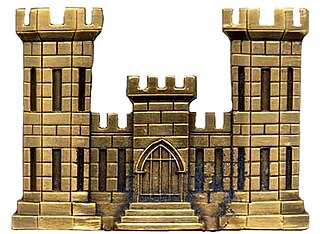
WCorps Castle is the logo of the U.S. Army Corps of Engineers (USACE). The logo is typically a white castle with three towers set on a red background. When the Corps Castle is worn as insignia on a uniform, it is similar to the logo design but with a dull or shiny brass finish. The look of the Corps Castle traces its history back to the American Revolution and has evolved over time. The logo has received changes throughout the years but gets its finalizing shape from the United States Military Academy Barracks named Pershing Barracks.
 W
WDalecarlia Reservoir is the primary storage basin for drinking water in Washington, D.C., fed by an underground aqueduct in turn fed by low dams which divert portions of the Potomac River near Great Falls and Little Falls. The reservoir is located between Spring Valley and the Palisades, two neighborhoods in Northwest Washington, and Brookmont, a neighborhood in Montgomery County, Maryland.
 W
WElk State Park is a 3,192-acre (1,292 ha) Pennsylvania state park in Jones Township, Elk County and Sergeant Township, McKean County, Pennsylvania, in the United States. East Branch Clarion River Lake is a man-made lake covering 1,160 acres (470 ha) within the park. The lake and streams in the park are stocked with cold and warm water fish. There are 3,151 acres (1,275 ha) of woods open to hunting.
The Engineer Research and Development Center (ERDC) is a US Army Corps of Engineers (USACE) laboratory organization whose mission is to "Provide science, technology, and expertise in engineering and environmental sciences in support of our Armed Forces and the Nation to make the world safer and better." The headquarters is located in Vicksburg, Mississippi, on the site of an antecedent organization, the Waterways Experiment Station.
 W
WGavins Point Dam is a 1.9 mi (3 km) long embankment rolled-earth and chalk-fill dam which spans the Missouri River and impounds Lewis and Clark Lake. The dam joins Cedar County, Nebraska with Yankton County, South Dakota a distance of 811.1 river miles (1,305 km) upstream of St. Louis, Missouri, where the river joins the Mississippi River. The dam and hydroelectric power plant were constructed as the Gavins Point Project from 1952 to 1957 by the United States Army Corps of Engineers as part of the Pick-Sloan Plan. The dam is located approximately 4 miles (6.4 km) west or upstream of Yankton, South Dakota.
The Geospatial Research Laboratory is a component of the Engineer Research and Development Center (ERDC), a US Army Corps of Engineers (USACE) laboratory organization whose mission is to "Provide science, technology, and expertise in engineering and environmental sciences in support of our Armed Forces and the Nation to make the world safer and better." The laboratory is colocated with the Army Geospatial Center in the Humphreys Engineer Center adjacent to Fort Belvoir. The headquarters is located in Vicksburg, Mississippi, on the site of an antecedent organization, the Waterways Experiment Station. GRL conducts geospatial research, development, technology and evaluation of current and emerging geospatial technologies that will help characterize and measure phenomena within the physical (terrain) and social (cultural) environments encountered by the Army. GRL research areas and capabilities include terrain analysis and reasoning; passive and active spectral signature analysis; fluorescence; photogrammetry; terrain visualization; precision surveying and mapping; image analysis; data management; geographic information systems; data/image fusion; and spatio-temporal reasoning and numerical analysis.
 W
WGuajataca Lake, or Lago Guajataca, is a reservoir created by the Puerto Rico Electric Power Authority in 1929. It is located between the municipalities of San Sebastián, Quebradillas, and Isabela in Puerto Rico. The dam at Guajataca Lake experienced a structural failure on September 22, 2017, due to the hit from Hurricane Maria. The river, Río Guajataca, also carries the name.
 W
WThe Gulf Intracoastal Waterway West Closure Complex is a part of the New Orleans Drainage System; it consists of a navigable floodgate, a pumping station, flood walls, sluice gates, foreshore protection, and an earthen levee. The complex was designed to reduce risk for residences and businesses in the project area from a storm surge associated with a tropical event, with an intensity that has a one percent chance of occurring in any given year. This project was operated for the first time on August 29, 2012, in response to Hurricane Isaac.
WThe United States Army Corps of Engineers (USACE) is an engineer formation of the United States Army that has three primary mission areas: engineer regiment, military construction, and civil works. The day-to-day activities of the three mission areas are administered by a lieutenant general known as the commanding general/chief of engineers. The chief of engineers commands the engineer regiment, composed of combat engineer army units, and answers directly to the chief of staff of the army. Combat engineers come from throughout the service and can be active duty, national guard, or army reserve. Combat engineers duties are to construct fighting positions, fixed/floating bridges, and obstacles and defensive positions, place and detonate explosives (sappers), conduct operations that include route clearance of obstacles and rivers, prepare and install firing systems for demolition and explosives, and detect mines. For the military construction mission the commanding general is directed and supervised by the assistant secretary of the army for installations, environment, and energy, whom the President appoints and the Senate confirms. Military construction relates to construction on military bases and worldwide installations.
 W
WThe Chief of Engineers is a principal United States Army staff officer at The Pentagon. The Chief advises the Army on engineering matters, and serves as the Army's topographer and proponent for real estate and other related engineering programs. The Chief of Engineers is the senior service engineer for the Department of Defense, responsible for integrating all aspects of combat, general and geospatial engineering across the Joint Force.
 W
WLake Clementine is a reservoir on the North Fork American River Canyon above the picturesque, California Gold Rush-era town of Auburn in Northern California. It was created in 1939 when the North Fork Dam, a 155-foot tall variable radius arch dam, was completed by the United States Army Corps of Engineers, for the purpose of containing gold-mining debris which were washing downriver. This resulting reservoir is a long and narrow lake approximately 3.5 miles long and 300 feet wide in some areas. The lake and surrounding area is owned by the United States Bureau of Reclamation and managed by California Department of Parks and Recreation.
 W
WLyons Ferry State Park is a public recreation area located near the confluence of the Snake and Palouse rivers, seven miles (11 km) northwest of Starbuck, Washington. The state park is on Route 261 abreast of Lake Herbert G. West, a reservoir on the Snake River created with the construction in the 1960s of the Lower Monumental Dam some 17 miles (27 km) downstream. The park offers facilities for boating, fishing, and swimming. The area is managed cooperatively by the Washington State Parks and Recreation Commission and the U.S. Army Corps of Engineers, which operates the Lyons Ferry Marina.
 W
WThe Malinta Tunnel is a tunnel complex built by the United States Army Corps of Engineers on the island of Corregidor in the Philippines. It was initially used as a bomb-proof storage and personnel bunker, but was later equipped as a 1,000-bed hospital. The main tunnel, running east to west, is 831 feet (253 m) long, 24 feet (7.3 m) wide and 18 feet (5.5 m) high. Branching off from this main shaft are 13 lateral tunnels on the north side and 11 lateral tunnels on the south side. Each lateral averaged 160 feet (49 m) in length and 15 feet (4.6 m) in width.
 W
WThe McNary Levee System, also known as the Tri-Cities Levees, is an appurtenant or dam-related structure to McNary Lock and Dam, and consists of three groups of levee segments along the banks of the Columbia River that provide flood risk reduction for portions of Kennewick, Pasco, and Richland, Washington. The levee group names are based on location and are identified as the Kennewick Levees, Pasco Levees, and Richland Levees. Lake Wallula behind McNary Lock and Dam is about 63 miles long and includes 242 miles of shoreline and a drainage area of 214,000 square miles. The McNary Levee System consists of about 16.8 miles of earthen levees and 11 operational pump plants that remove agricultural runoff, groundwater migration, and rainfall runoff. Construction of the McNary Levee System began in 1950 and was completed in 1954.
 W
WM/V Mississippi is a United States Army Corps of Engineers (USACE) towboat operating on the Mississippi River. It is the largest diesel towboat on the river.
 W
WThe Morganza Spillway or Morganza Control Structure is a flood-control structure in the U.S. state of Louisiana along the western bank of the Lower Mississippi River at river mile 280, near Morganza in Pointe Coupee Parish. The spillway stands between the Mississippi and the Morganza Floodway, which leads to the Atchafalaya Basin and the Atchafalaya River in south-central Louisiana. Its purpose is to divert water from the Mississippi River during major flood events by flooding the Atchafalaya Basin, including the Atchafalaya River and the Atchafalaya Swamp. The spillway and adjacent levees also help prevent the Mississippi from changing its present course through the major port cities of Baton Rouge and New Orleans to a new course down the Atchafalaya River to the Gulf of Mexico. The Morganza Spillway, operated by the U.S. Army Corps of Engineers, was opened during the 1973 and 2011 Mississippi River floods.
 W
WThe Okeechobee Waterway or Okeechobee Canal is a relatively shallow man-made waterway in the United States, stretching across Florida from Fort Myers on the west coast to Stuart on Florida's east coast. The waterway can support tows such as barges or private vessels up to 50 feet wide x 250 feet long which draw less than 10 feet, as parts of the system, especially the locks may have low water depths of just ten feet. The system of channels runs through Lake Okeechobee and consists of the Caloosahatchee River to the west of the lake and the St. Lucie Canal (C-44) east of the lake.
WThe Okeechobee Waterway or Okeechobee Canal is a relatively shallow man-made waterway in the United States, stretching across Florida from Fort Myers on the west coast to Stuart on Florida's east coast. The waterway can support tows such as barges or private vessels up to 50 feet wide x 250 feet long which draw less than 10 feet, as parts of the system, especially the locks may have low water depths of just ten feet. The system of channels runs through Lake Okeechobee and consists of the Caloosahatchee River to the west of the lake and the St. Lucie Canal (C-44) east of the lake.
The Portland District is one of the five districts within the Northwestern Division of the United States Army Corps of Engineers. The Portland District is made up of some 1,100 civilian and 6 military personnel.
 W
WThe project design flood is a hypothetical "maximum probable" flood of the Mississippi River used by the United States Army Corps of Engineers to aid in the design and execution of flood protection in the Mississippi Valley.
 W
WThe Inner Harbor Navigation Canal (IHNC) Seabrook Floodgate Structure is a flood barrier in the Industrial Canal in New Orleans, Louisiana. The floodgate is designed to protect the Industrial Canal and the surrounding areas from a storm surge from Lake Ponchartrain. It consists of two 50-foot (15 m) wide vertical lift gates and a 95-foot (29 m) wide sector gate.
 W
WSergeant Floyd is a historic museum boat, serving as the Sergeant Floyd River Museum & Welcome Center at 1000 Larsen Park Road in Sioux City, Iowa. Built in 1932 as a utility vehicle and towboat, she is one of a small number of surviving vessels built specifically for the United States Army Corps of Engineers in its management of the nation's inland waterways. The boat has been restored and drydocked, and now houses exhibits about the Missouri River and local tourism information. The museum is a facility of the Sioux City Public Museum.
 W
WShpack Landfill is a hazardous waste site in Norton, Massachusetts. After assessment by the United States Environmental Protection Agency (EPA) it was added to the National Priorities List in October 1986 for long-term remedial action. The site cleanup is directed by the federal Superfund program. The Superfund site covers 9.4 acres, mostly within Norton, with 3.4 acres in the adjoining city of Attleboro. The Norton site was operated as a landfill dump accepting domestic and industrial wastes, including low-level radioactive waste, between 1946 and 1965. The source of most of the radioactive waste, consisting of uranium and radium, was Metals and Controls Inc. which made enriched uranium fuel elements for the U.S. Navy under contract with the U.S. Atomic Energy Commission. Metals and Controls merged with Texas Instruments in 1959. The Shpack landfill operation was shut down by a court order in 1965.
 W
WThe Soo Locks are a set of parallel locks, operated and maintained by the United States Army Corps of Engineers, Detroit District, which enable ships to travel between Lake Superior and the lower Great Lakes. They are located on the St. Marys River between Lake Superior and Lake Huron, between the Upper Peninsula of the US state of Michigan and the Canadian province of Ontario. They bypass the rapids of the river, where the water falls 21 feet (6.4 m). The locks pass an average of 10,000 ships per year, despite being closed during the winter from January through March, when ice shuts down shipping on the Great Lakes. The winter closure period is used to inspect and maintain the locks.
 W
WTower 270 is a 28-story mixed use building in the Civic Center and Tribeca neighborhoods of Manhattan, New York City. Completed in 1930 to designs by E.H. Faile & Company, it has 350,785 square feet (32,589.0 m2) of floor space, on a plot with 50 feet (15 m) facing Broadway to the east and 242 feet (74 m) on Chambers Street to the north.
 W
WTully Lake, of Royalston, Massachusetts, is a 1,262-acre (511 ha) reservoir and flood control project constructed by the United States Army Corps of Engineers (USACE) in 1949 for 1.6 million dollars. The project prevents flooding of the greater Connecticut River and Millers River valleys and provides a variety of recreational opportunities, including a campground operated by The Trustees of Reservations. Tully Lake is an important link in the 22-mile (35 km) Tully Trail.
 W
WThe U.S. Army Corps of Engineers Duluth Vessel Yard is a federal port facility in Duluth, Minnesota, United States. It houses the United States Army Corps of Engineers (USACE) resources used to maintain the harbors of the Twin Ports of Duluth and Superior, Wisconsin. It was established on Minnesota Point in 1903, though most of its present configuration dates to a flurry of construction in 1941.
The U.S. Army Corps of Engineers Europe District, (NAU) provides both installation and contingency support to U.S. forces throughout the United States European Command area of responsibility. Headquartered in Wiesbaden, Germany, the district, which is part of the North Atlantic Division, covers a widely dispersed geographic area from Western Europe across Eastern Europe, including Russia, down to Israel and throughout most of the African continent. Work is executed from offices in Germany, Belgium, Turkey, Romania, Italy, Spain, Kosovo, Israel, Bulgaria, and Georgia. In 2009, the district completed more than $1.2 billion in projects including $648 million in military construction projects. The bulk of this work included Army and Air Force Family Housing units, forward operating sites in Eastern Europe, and training and operations facilities.
 W
WThe U.S. Army acquired ten ships during World War II as Engineer Port Repair Ships, also sometimes known as Port Rehabilitation ships, for use by the U.S. Army Corps of Engineers to clear war damaged harbors. The need was anticipated by 1942 for the post invasion recovery of ports in Europe and the Transportation Corps was assigned the responsibility to acquire and modify the ships that would be military crewed under the Corps of Engineers.
 W
WThe United States Army Engineer School (USAES) is located at Fort Leonard Wood, Missouri. It was founded as a School of Engineering by General Headquarters Orders, Valley Forge on 9 June 1778. The U.S. Army Engineer School provides training that develops a wide variety of engineering skills including: combat engineer, bridging, construction, geospatial, topography, diving, and firefighting.
 W
WThe Waterways Experiment Station, also known as WES-Original Cantonment in Vicksburg, Mississippi, is a sprawling 673-acre (272 ha) complex built in 1930 as a United States Army Corps of Engineers research facility. Its campus is the site of the headquarters of the Engineer Research and Development Center (ERDC) of the Corps of Engineers. WES is the largest of the four Corps of Engineers' research and development laboratories.
 W
WThe West Atchafalaya Floodway is a flood control structure of the Mississippi River and Tributaries Project located in the Lower Atchafalaya Basin in south-central Louisiana. It has a project design flood flow capacity of 250,000 cu ft/s (7,100 m3/s).
 W
WThe Willamette Falls Locks are a lock system on the Willamette River in the U.S. state of Oregon. Opened in 1873 and closed since 2011, they allowed boat traffic on the Willamette to navigate beyond Willamette Falls and the T.W. Sullivan Dam. Since their closure in 2011 the locks are classified to be in a "non-operational status" and are expected to remain permanently closed.
 W
WWilson Dam is a dam spanning the Tennessee River between Lauderdale County and Colbert County in the U.S. state of Alabama. Completed in 1924 by the United States Army Corps of Engineers, it impounds Wilson Lake, and is one of nine Tennessee Valley Authority (TVA) dams on the Tennessee River. The dam was declared a National Historic Landmark on November 13, 1966, for its role as the first dam to come under the TVA's administration. The dam is named for former President of the United States Woodrow Wilson.