 W
WSoldier settlement, also known as the Soldier Settlement Scheme or Soldiers Settlement Scheme, administered by the Soldier Settlement Commission, was the settlement of land throughout parts of Australia by returning discharged soldiers under schemes administered by the state governments after World War I and World War II.
 W
WBarmera is a town in the Riverland region of South Australia. It is on the Sturt Highway A20, 220 kilometres north-east of Adelaide, the capital of the state of South Australia. It is primarily an agricultural and viticultural town and is located on Lake Bonney Riverland, a freshwater lake. The population was 1,914 in 2011.
 W
WBatlow is a town in the South West Slopes region of New South Wales, Australia, on the edge of the Great Dividing Range, 775 m above sea level.
 W
WColignan is a small rural town on the banks of the Murray River, in North Western Victoria, Australia. The town is on the border of the Hattah-Kulkyne National Park. At the 2016 census, Colignan and the surrounding area had a population of 329.
 W
WDareton is a town in the far west of New South Wales, Australia. The town is located on the Silver City Highway, 1,025 kilometres west of the state capital, Sydney and 20 kilometres from the regional centre, Mildura, across the border in Victoria. Part of the Wentworth Shire local government area, at the 2011 census, Dareton had a population of 516.
 W
WDorrigo, a small town on the Waterfall Way, is located on the Northern Tablelands, in northern New South Wales, Australia. The town is part of Bellingen local government area.
 W
WGlossop is a small town in the Riverland region of South Australia. It was gazetted in 1921 as the town in a soldier settlement area after the First World War and was named after Admiral Glossop, who had been in command of HMAS Sydney when it sank SMS Emden in 1914. At the 2016 census, Glossop had a population of 984.
 W
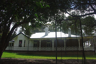
WThe Grantham Poultry Research Station is a heritage-listed former poultry farm and research station and now heritage reserve at 71 Seven Hills Road, Seven Hills, City of Blacktown, New South Wales, Australia. It includes two historic residences, Melrose and Drumtochty. The site is today known as the Grantham Heritage Park, and has previously been known as Seven Hills Agricultural Station and the Grantham State Poultry Farm. It was built from 1897 to 1939. It was added to the New South Wales State Heritage Register on 7 April 2000.
 W
WThe Heytesbury Settlement Scheme was a soldier settlement scheme established in the Western District of Victoria, Australia after World War II. The scheme involved the clearing of the Heytesbury Forest south of Colac, Victoria and adjacent to the Otway Ranges to allow for the establishment of a dairy industry in the area. Established in 1960 by the Victorian Government led by Premier Henry Bolte, some early problems saw the scheme dismissed as "Bolte's Blunder". In time the area became one of Australia's most productive dairy regions. The scheme was one of the last large scale land settlement schemes in Victoria.
 W
WHillsdale is a suburb in the Eastern Suburbs of Sydney, in the state of New South Wales, Australia. Hillsdale is located 6 kilometres south-east of the Sydney central business district in the Bayside Council. The suburb is named after Pat Hills, former Deputy Premier of New South Wales.
 W
WHillston is a township in western New South Wales, Australia, in Carrathool Shire, on the banks of the Lachlan River. It was founded in 1863 and at the 2016 census had a population of 1,465.
 W
WIraak is a town in Victoria, Australia, located approximately 35 km south-east of Mildura, Victoria.
 W
WKangaroo Island, also known as Karta, is Australia's third-largest island, after Tasmania and Melville Island. It lies in the state of South Australia 112 km (70 mi) southwest of Adelaide. Its closest point to the mainland is Snapper Point in Backstairs Passage, which is 13.5 km (8.4 mi) from the Fleurieu Peninsula.
 W
WKarlgarin is a town located 321 kilometres (199 mi) south-east of Perth in the eastern Wheatbelt region of Western Australia. A small traditional farming town, in 2010 Karlgarin made national papers, as the poorest town in Western Australia, with an average of $34,054 taxable income.
 W
WKentucky is a village in the New England region of New South Wales, Australia. It is about 17 kilometres (11 mi) south of Uralla and 35 kilometres (22 mi) north-west of Walcha and about 7 kilometres (4 mi) off the New England Highway. Kentucky is located 540 kilometres (336 mi) by rail from Sydney in Sandon County on the Northern Tablelands. It is at an altitude of 1066m and is within Uralla Shire. At the 2016 census, Kentucky had a population of 158.
 W
WLemnos is a locality in the Goulburn Valley region of Victoria, Australia, on the outskirts of the regional city of Shepparton. At the 2006 census, Lemnos had a population of 369, which had dropped to 246 at the 2016 census.
 W
WLurnea is a suburb of Sydney, in the state of New South Wales, Australia. It is 35 kilometres south-west of the Sydney central business district, in the local government area of the City of Liverpool.
 W
WMatraville is located in the Eastern Suburbs of Sydney, in the state of New South Wales, Australia. It is approximately 9 km (6 mi) by road south-east of the Sydney central business district, in the local government area of the City of Randwick.
 W
WMerbein is a town just north of Mildura, Victoria, in the Sunraysia region of Australia. It is on the Calder Highway between Mildura and the Murray River crossing at the Abbotsford Bridge to Curlwaa. At the 2016 census, the town had a population of 1,981. Merbein is 12 kilometres from Mildura, 553 km from Melbourne and 389 km from Adelaide.
 W
WMonash is a town in the Riverland area of South Australia. It is on the Sturt Highway between Barmera and Renmark. At the 2006 census, Monash had a population of 1,115.
 W
WMortlake is a town in the Western District of Victoria, Australia on the Hamilton Highway, 50 kilometres (31 mi) north-east of Warrnambool. It is in the Shire of Moyne local government area and the federal Division of Wannon. At the 2001 census, Mortlake had a population of 941, rising to 996 in 2006, and to 1,073 in 2011.
 W
WMurray Bridge is a city in the Australian state of South Australia, located 76 kilometres (47 mi) east-southeast of the state's capital city, Adelaide, and 77 kilometres (48 mi) north of the town of Meningie. The city had an urban population of approximately 18,779 as at June 2018 making it the fifth most populous urban area in the state after Adelaide, Mount Gambier, Victor Harbor - Goolwa and Whyalla.
WNangiloc is a small rural community in North Western Victoria on the south (left) bank of the Murray River, about 50 km south east of Mildura. Primarily an agricultural settlement, at the 2016 census, Nangiloc and the surrounding area had a population of 141.
 W
WPadthaway is a small town in the Australian state of South Australia located in the state's south-east within the Limestone Coast region about 253 kilometres south east of the state capital of Adelaide and about 41 kilometres south-east of the municipal seat of Bordertown. The name is derived from the Potawurutj, the Aboriginal name for Good Water. Padthaway is in the Tatiara District Council, the state electorate of MacKillop and the federal Division of Barker.
 W
WParndana is a town and locality in the Australian state of South Australia located on Kangaroo Island about 155 kilometres (96 mi) southwest of the state capital of Adelaide and about 40 kilometres (25 mi) southwest of the municipal seat of Kingscote.
 W
WPatchewollock is a town in north-west Victoria, Australia. At the 2016 census, Patchewollock had a population of 133.
 W
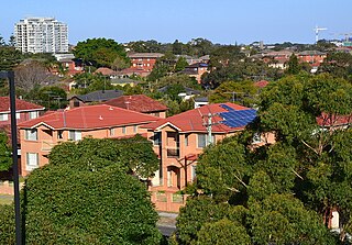
WSeven Hills is a suburb in the Greater Western Sydney region of Sydney, in the state of New South Wales, Australia, located 27 kilometres North West of the Sydney central business district. Seven Hills is within the local government areas of the City of Parramatta and Blacktown City councils. The suburb is sometimes referred to as part of the Hills District.
 W
WSimpson is a small town in the Western District of Victoria Australia. The town is in a dairying region and lies about halfway between Colac and the coastal fishing resort of Port Campbell. Most of the town is located in the Corangamite Shire, but a small, forested section lies in the Shire of Colac Otway. Simpson is 20 kilometres (12 mi) south of Cobden. At the 2016 census, Simpson had a population of 569.
 W
WStirling is a suburb of Perth, the capital city of Western Australia, about 10 km north of Perth's central business district (CBD) along the Mitchell Freeway. Its local government area is the City of Stirling, whose council offices and administration centre are located in the southwest of the mostly residential suburb.
 W
WTrawalla is a town in central Western Victoria, Australia, located on the Western Highway, 41 kilometres (25 mi) west of Ballarat and 154 kilometres (96 mi) west of Melbourne, in the Shire of Pyrenees. At the 2006 census, Trawalla and the surrounding agricultural area had a population of 224.
 W
WTullakool is a village community in the south west part of the Riverina. The place by road, is situated about 23 kilometres east from Burraboi and 27 km (17 mi) west from Wakool. It was the location of the first commercial rice crop in the Murray valley. At the 2006 census, Tullakool had a population of 330.
 W
WWaikerie is a rural town in the Riverland region of South Australia on the south bank of the Murray River. At the 2016 census, Waikerie had a population of 2,684. The Sturt Highway passes to the south of the town at the top of the cliffs. There is a cable ferry crossing the river to provide vehicle access from the north side of the river. Waikerie is known for citrus growing, along with stone fruit and grapes.
 W
WWollert is a suburb in Melbourne, Victoria, Australia, 26 km north of Melbourne's central business district. Its local government area is the City of Whittlesea. At the 2016 census, Wollert had a population of 9,060.
 W
WYarroweyah is a town in northern Victoria, Australia. The town is located in the Shire of Moira local government area, 251 kilometres (156 mi) north of the state capital, Melbourne and 10 kilometres (6 mi) west of Cobram. The town is situated near the intersection of Kenny Road, Kokoda Road and the Murray Valley Highway. At the 2016 census, Yarroweyah and the surrounding area had a population of 548.
 W
WYarrowitch is a small rural locality on the Northern Tablelands, New South Wales, Australia. It is located in the picturesque Yarrowitch River Valley on the Oxley Highway 48 kilometres east of Walcha. The settlement is included in the Walcha Shire Local Government Area in the New England region. The locality is at an elevation of about 995 metres and the area is part of Vernon County. At the 2011 census, the Yarrowitch area had a population of 167.