 W
WAccomack County Airport is a county-owned public-use airport located 1 mile (1.6 km) west of the central business district of Melfa, a town in Accomack County, Virginia, United States.
 W
WAlkali Lake State Airport, is a public airport located 8 miles (13 km) northeast of Alkali Lake in Lake County, Oregon, United States.
 W
WAmedee Army Airfield is a military use airport located nine nautical miles (17 km) north of the central business district of Herlong, in Lassen County, California, United States. It is owned by the United States Army and located at the Sierra Army Depot in the Honey Lake Valley, east of the Sierra Nevada mountain range.
 W
WAurora State Airport is a public airport located one mile (2 km) northwest of the central business district of Aurora, a city in Marion County, Oregon, United States. It is owned by the Oregon Department of Aviation.
 W
WBrookhaven Calabro Airport is a public airport located one mile (1.6 km) north of the central business district of Shirley, in Suffolk County, New York, United States. This airport is publicly owned by the Town of Brookhaven. The airport contact information, description, list of fixed-base operators and other tenants is maintained on the Town of Brookhaven's webpage for the Division of Aviation / Department of General Services."Brookhaven Calabro Airport".
 W
WCarrabelle–Thompson Airport is a public use airport located three nautical miles (6 km) west of the central business district of Carrabelle, a city in Franklin County, Florida, United States. It is owned by the Carrabelle Port and Airport Authority.
 W
WCurrituck County Regional Airport is a county-owned, public-use airport in Currituck County, North Carolina, United States. It is located four nautical miles south of the central business district of Currituck, North Carolina. This airport is included in the National Plan of Integrated Airport Systems for 2011–2015, which categorized it as a general aviation facility. It was previously known as Currituck County Airport or Currituck Regional Airport.
 W
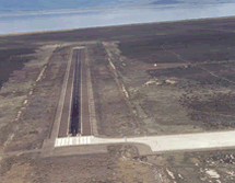
WDeblois Flight Strip is a public-use airport located two nautical miles southeast of the central business district of Deblois, a town in Washington County, Maine, United States. It is currently owned by the Maine Department of Transportation, and managed by Randy Gray, Superintendent of Operations for the Eastern Region.
 W
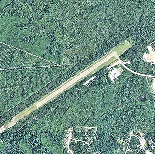
WDell Flight Strip is a public-use airport located one nautical mile northwest of the central business district of Dell, in Beaverhead County, Montana, United States. It is owned by the Montana Department of Transportation Aeronautics Division and provides general aviation service.
 W
WThe Florida Keys Marathon International Airport is a public airport located along the Overseas Highway (US1) in Marathon, in Monroe County, Florida, United States. The airport covers 197 acres (80 ha) and has one runway.
 W
WFurnace Creek Airport is a public airport located 0.75 miles (1 km) west of Furnace Creek, Death Valley, serving Inyo County, California, USA. This general aviation airport covers 40 acres (16 ha) and has one runway. At −210 feet (−64 m) MSL, it is the lowest elevation airport in North America.
 W
WGrand Strand Airport is a county-owned, public-use airport located one nautical mile (1.85 km) northwest of the central business district of North Myrtle Beach, in Horry County, South Carolina, United States. The name Grand Strand refers to a nearby 60-mile stretch of beach.
 W
WEddie Andreini Sr. Airfield is a public airport in San Mateo County, six miles (9 km) northwest of Half Moon Bay, California, United States. The airport is on the Pacific Coast, south of San Francisco.
 W
WLeadville Municipal Airport was a Colorado World War II Army Airfield "adjacent to Highway No. 24" and named for Leadville, Colorado, 2 mi (3.2 km) southeast.
WLeadville Municipal Airport was a Colorado World War II Army Airfield "adjacent to Highway No. 24" and named for Leadville, Colorado, 2 mi (3.2 km) southeast.
 W
WBuckley Air Force Base is a United States Air Force base in Aurora, Colorado. It was established by the U.S. Army as an auxiliary field and bombing range in 1938, and activated as a designated installation in 1941. The base was named in honor of World War I Army pilot First Lieutenant John Harold Buckley.
 W
WNapa County Airport is a public airport five miles (8 km) south of Napa, in Napa County, California, United States. It has three runways.
 W
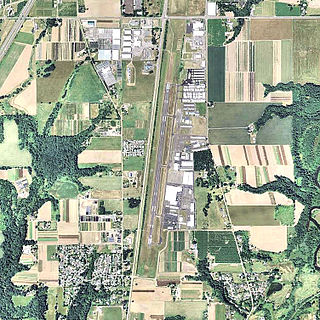
WOmak Airport, also known as Omak Municipal Airport or Omak City Airport, is a regional airport located 3 miles (4.8 km) north of Omak, Washington, a city in the Okanogan region of United States. It is owned and operated by the Omak City Council and serves Omak, although it is situated in nearby town Riverside's city limits rather. The airport was built by the United States Army Air Forces around 1942 and was approved for public use the following year. After World War II ended, it was closed and turned over for local government use by the War Assets Administration (WAA). Throughout its history, a number of improvements and expansions have occurred with its terminal, runways and taxiways, specifically in June 1979, when improvements made around that month were celebrated with an air show presentation.
 W
WOwyhee Airport is a public use airport located 4 nautical miles west of the central business district of Owyhee, in Elko County, Nevada, United States. It is owned by the Shoshone-Paiute Tribes and is located within the Duck Valley Indian Reservation.
WAmedee Army Airfield is a military use airport located nine nautical miles (17 km) north of the central business district of Herlong, in Lassen County, California, United States. It is owned by the United States Army and located at the Sierra Army Depot in the Honey Lake Valley, east of the Sierra Nevada mountain range.
 W
WRome State Airport is a public use airport located 20 nautical miles southwest of the central business district of Rome, in Malheur County, Oregon, United States. It is owned by the Oregon Department of Aviation.
 W
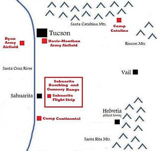
WThe Sahuarita Air Force Range, also known as the Sahuarita Bombing & Gunnery Range, was built just east of Sahuarita, Arizona, in 1942. It was used for the training of bombardiers, aerial gunners, anti-aircraft gunners, and others during World War II and the Korean War. The abandoned Sahuarita Flight Strip is located in the southwestern corner of the range, and was used as an emergency flight strip until 1978. Before deactivation, the airspace over the range was protected by its own restricted area, R-310.
 W
WYolo County Airport is six miles northeast of Winters, five miles northwest of Davis and five miles southwest of Woodland, all in Yolo County, California. Magnetic variation is 16E.
WYolo County Airport is six miles northeast of Winters, five miles northwest of Davis and five miles southwest of Woodland, all in Yolo County, California. Magnetic variation is 16E.
 W
WZamperini Field is a public airport three miles (5 km) southwest of downtown Torrance, in Los Angeles County, California, United States.