 W
WBethel Air Force Station is a closed United States Air Force General Surveillance Radar station. It was located 402 miles (647 km) west of Anchorage, Alaska.
 W
WCamp Gary was the United States military installation that was redeveloped into the San Marcos Municipal Airport and the Gary Job Corps Center, the largest in the nation.
 W
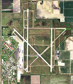
WChennault International Airport is a public use airport located four nautical miles (7 km) east of the central business district of Lake Charles, a city in Calcasieu Parish, Louisiana, United States. It is owned by the Chennault International Airport Authority. The main runway is the longest at any airport between Houston and Cape Canaveral.
WDemarcation Bay DEW Line Station is an abandoned United States Air Force Distant Early Warning Line Radar station located on the north coast of Alaska, United States. The site is situated on Nuvagapak Point, about 25 miles (40 km) northeast of the topographical Demarcation Bay and 35 miles (56 km) from the border with Canada. Situated 349 miles (562 km) east of Point Barrow, it was the most remote DEW site in Alaska. Demarcation Bay DEW Line Station was closed in 1964, and is not open for public use.
 W
WDonaldson Air Force Base is a former facility of the United States Air Force located south of Greenville, South Carolina. It was founded in 1942 as Greenville Army Air Base; it was deactivated in 1963 and converted into a civilian airport. It is currently an active airfield known as Donaldson Center Airport.
 W
WFort Lawton Air Force Station is a closed United States Air Force General Surveillance Radar station. It is located on Fort Lawton in the Magnolia neighborhood of northwest Seattle, Washington. The Air Force inactivated its unit in 1963; while the site remained under Army control until 1974. Today the Federal Aviation Administration (FAA) operates the site as part of the Joint Surveillance System (JSS).
 W
WFort Niagara is a fortification originally built to protect the interests of New France in North America. It is located near Youngstown, New York, on the eastern bank of the Niagara River at its mouth, on Lake Ontario.
WGrand Rapids Air Force Station is a closed United States Air Force General Surveillance Radar station. It is located 0.7 miles (1.1 km) east-northeast of Grand Rapids, Minnesota. It was closed in 1963.
 W
WHarlingen Air Force Base, originally Harlingen Army Airfield, is a former United States Air Force base in northeast Harlingen, Texas. After the base closed, the field was redeveloped into Valley International Airport.
 W
WHenry C. Mustin Naval Air Facility, also known as Mustin Field, is a former military airfield located at the United States Navy Naval Aircraft Factory on board the Philadelphia Naval Shipyard, Philadelphia, Pennsylvania. It was in service from 1926 to 1963.
WIcy Cape Air Force Station is an abandoned United States Air Force Distant Early Warning Line Radar station at Icy Cape on the Chukchi Sea coast of northwestern Alaska, United States. It was closed in 1963.
 W
WWest Fort Hood is an underground weapons storage area adjacent to Fort Hood in Texas. Originally built in the late 1940s by the United States Air Force, it was adjacent to Gray Air Force Base. On 15 June 1963 Killeen Base was turned over to the Army, and in October 1969, Killeen Base was designated as West Fort Hood and the airfield's name was designated as Robert Gray Army Airfield. It is also home to the Army Operational Test Command.
 W
WLas Cruces Air Force Station is a closed United States Air Force General Surveillance Radar station. It is located 12.1 miles (19.5 km) west-southwest of Las Cruces, New Mexico. It was closed in 1963.
 W
WMiddleton Island Air Force Station is a closed United States Air Force General Surveillance Radar station. It was located on Middleton Island, in the Gulf of Alaska, 173 miles (278 km) south of Anchorage, Alaska.
 W
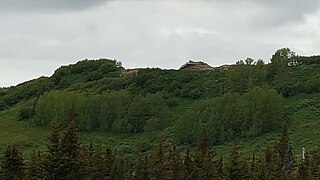
WOhlson Mountain Air Force Station is a closed United States Air Force General Surveillance Radar station. It was located 118 miles (190 km) south-southwest of Anchorage, Alaska.
 W
WOzona Air Force Station is a closed United States Air Force General Surveillance Radar station. It is located 5 miles (8.0 km) east of Ozona, Texas. It was closed in 1963.
 W
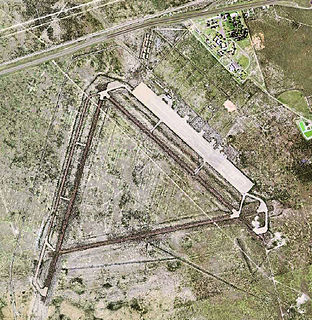
WPyote Air Force Base was a World War II United States Army Air Forces training airbase. It was on 2,745 acres (1,111 ha) a mile from the town of Pyote, Texas on Interstate 20, 20 miles west of Monahans and just south of U.S. Highway 80, 230 miles (370 km) east of El Paso.
WRockport Air Force Station is a closed United States Air Force General Surveillance Radar station. It is located 4.1 miles (6.6 km) southwest of Lamar, Texas. It was closed in 1963.
 W
WSanta Rosa Island Air Force Station is a closed United States Air Force General Surveillance Radar station. It is located 5.8 miles (9.3 km) southwest of the Santa Rosa Island dock, California. It was closed in 1963.
 W
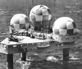
WTexas Tower 2 was a former United States Air Force Texas Tower General Surveillance Radar station, first operational in 1955. It was located 110 miles (180 km) east of Cape Cod, Massachusetts, in 56 feet (17 m). The tower was closed in 1963 and dismantled.
 W
WTexas Tower 3 was a former United States Air Force Texas Tower General Surveillance Radar station, first operational in November 1956. 50 miles (80 km) southeast of the coast of Nantucket, Massachusetts, in 80 feet of water. The tower was closed in 1963 and dismantled.
 W
WWalnut Ridge Air Force Station is a closed United States Air Force General Surveillance Radar station. It is located 4.7 miles (7.6 km) north-northeast of Walnut Ridge, Arkansas. It was closed in 1963.
 W
WWinslow Air Force Station is a closed United States Air Force General Surveillance Radar station. It is located in Coconino County, Arizona, 8.7 miles (14.0 km) west-northwest of Winslow, Arizona. It was closed in 1963.
 W
WRAF Wymeswold is a former Royal Air Force station located 3.5 miles (5.6 km) north-east of Loughborough, Leicestershire, England. The airfield is situated between Hoton, Wymeswold and Burton on the Wolds, lying in the current district of Charnwood.