 W
WThe Fortified Sector of Altkirch was the French military organization that in 1940 controlled the section of the French frontier with Germany and Switzerland in the vicinity of Basel. The sector's principal defense against an advance from Germany was the Rhine itself, which could be crossed only by boat or by seizing a bridge crossing. The frontier with Switzerland was not regarded as a high-risk location, save for a possible advance by German forces through Switzerland. Originally planned as a full extension of the Maginot Line with artillery ouvrages, the sector's fortifications were scaled back and chiefly took the form of casemates and blockhouses. The SF Altkirch adjoined the Fortified Sector of Mulhouse to the north and the Fortified Sector of Montbéliard to the west.
 W
WThe Fortified Sector of Boulay was the French military organization that in 1940 controlled the section of the Maginot Line to the north and east of Metz in northeastern France. The left (western) wing of the Boulay sector was among the earliest and strongest portions of the Maginot Line. The right wing, started after 1931, was progressively scaled back in order to save money during the Great Depression. It was attacked in 1940 by German forces in the Battle of France. Despite the withdrawal of the mobile forces that supported the fixed fortifications, the sector successfully fended off German assaults before the Second Armistice at Compiègne. The positions and their garrisons finally surrendered on 27 June 1940. Following the war many positions were reactivated for use during the Cold War. Three locations are now preserved and open to the public.
 W
WThe Fortified Sector of Colmar was the French military organization that in 1940 controlled the section of the French frontier with Germany in the vicinity of Colmar. The fortifications were built as part of France's Maginot Line defensive strategy, but the sector lacks the large interconnected fortifications found along France's land border with Germany. The sector's principal defense was the Rhine itself, which could be crossed only by boat or by seizing a bridge crossing. The sector's fortifications chiefly took the form of casemates and blockhouses. The SF Colmar was flanked to the north by the Fortified Sector of the Lower Rhine to the north and the Fortified Sector of Mulhouse to the south. The Colmar sector was directly attacked by German forces on 15 June 1940, capturing or destroying most of the fortifications in the sector in three days.
 W
WThe Fortified Sector of the Crusnes was the French military organization that in 1940 controlled the section of the Maginot Line extending eastwards approximately 28 kilometres (17 mi) from Longuyon. The sector roughly follows the valley of the Crusnes river. Crucially, the trace of the Maginot Line in the Crusnes sector is about 7 kilometres (4.3 mi) behind the industrial city of Longwy which sits directly against the French borders with Belgium and Luxembourg. The Crusnes sector was one of the strongest Maginot Line sectors. It was attacked in 1940 by German forces in the Battle of France. Despite the withdrawal of the mobile forces that supported the fixed fortifications, the sector successfully fended off German assaults before the Second Armistice at Compiègne. The positions and their garrisons finally surrendered on 27 June 1940. Following the war many positions were reactivated for use during the Cold War. Three locations are now preserved and open to the public, with a fourth position under restoration.
 W
WThe Fortified Sector of the Dauphiné was the French military organization that in 1940 controlled the section of the Alpine Line portion of the Maginot Line facing Italy in the vicinity of Briançon. By comparison with the integrated defenses of the main Maginot Line, or even of the Fortified Sector of the Maritime Alps to the south, the Dauphiné sector consisted of a series of distinct territories that covered two main invasion routes into France: the route from Turin over the Col de Montgenèvre to Briançon and Grenoble, and the route from Coni over the Col de Larche to Barcelonette and Gap. The sector was the scene of probing attacks by Italian forces during the Italian invasion of France in 1940, in which the French defenses successfully resisted Italian advances until the June 1940 armistice that granted Italy access to southeastern France.
 W
WThe Defensive Organization of Corsica was the French military organization that in 1940 was responsible for the defense of the French island of Corsica against a potential invasion by Fascist Italy. As part of the overall effort to fortify France's borders which included the Maginot Line, the fixed Corsican defenses were constructed in parallel with the Maginot Line, using the same organizational structure and similar designs, albeit scaled back in size, cost and fighting power. The Corsican defenses were designed to deter an Italian landing on the south end of Corsica, and to support artillery batteries capable of controlling the Strait of Bonifacio between Corsica and the Italian island of Sardinia, separated by only twelve kilometers. As World War II unfolded, no attempt was made by Italian forces to mount an opposed landing on Corsica. The island was instead occupied in November 1942. In 1943 Corsica saw fighting when German forces moved from Sardinia. Most of the fortified positions remain to the present day.
 W
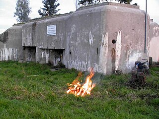
WThe Fortified Sector of Faulquemont was the French military organization that in 1940 controlled the section of the Maginot Line in the area of Faulquemont to the east of Metz. With five petit ouvrages the sector was poorly equipped with fortress artillery, limiting the ouvrages ability to provide mutual support. The sector was attacked in 1940 by German forces in the Battle of France. Despite the withdrawal of the mobile forces that supported the fixed fortifications, the sector mounted a strong resistance. Two of the petit ouvrages fell to German attack, the remainder holding out until the Second Armistice at Compiègne. The surviving positions and their garrisons finally surrendered on 2 June 1940. During the Cold War, Ouvrage Kerfent was partially reactivated as a communications station for Royal Canadian Air Force units stationed in northwestern France with NATO. At present, most of the underground works in the sector are flooded by groundwater. Only Ouvrage Bambesch has been preserved and may be toured by the public.
 W
WThe Fortified Sector of Haguenau was the French military organization that in 1940 controlled the most easterly section of the Maginot Line, to the north of Strasbourg. The left (western) wing of the Haguenau sector adjoined the Fortified Sector of the Vosges, includes two of the largest Maginot fortifications, Ouvrage Hochwald and Ouvrage Schoenenbourg. The right wing, started after 1931, was progressively scaled back in order to save money during the Great Depression, abandoning plans for four petit ouvrages and substituting casemates. The sector's northern and eastern sides bordered on Germany. To the south the sector borders the Fortified Sector of the Lower Rhine, from which it received several casemates in a boundary shift in 1940.
 W
WThe Fortified Sector of the Lower Rhine was the French military organization that in 1940 controlled the section of the French frontier with Germany in the vicinity of Strasbourg. The sector's principal defence was the Rhine itself, which could be crossed only by boat or by seizing a bridge crossing. While it was constructed by CORF, the organization responsible for the construction of the Maginot Line, the SF Lower Rhine was not a part of the core Line fortifications. The sector's fortifications chiefly took the form of individual casemates and blockhouses. Additional support was provided by the fortress ring around Strasbourg, whose fortifications were still active in 1940. The SF Lower Rhine was flanked to the north by the Fortified Sector of Haguenau and to the south by the Fortified Sector of Colmar. The Rhinau section of the SF Lower Rhine was attacked by German forces in June 1940 as a diversion from the main German invasion operation in the SF Colmar. Follow-up incursions from the north and at Strasbourg left much of the SF Lower Rhine in German hands by the armistice of 25 June.
 W
WThe Fortified Sector of Maubeuge was the French military organization that in 1940 controlled the section of the Maginot Line between the French border with Belgium and Maubeuge, a distance of about 70 kilometres (43 mi). The sector was not as strongly defended as other sections of the Maginot Line Large portions of the Maubeuge sector were defended by blockhouses or casemates. The sector includes only four ouvrages of the type found in stronger sections of the Line, arranged in an arc to the north and east of the fortified city of Maubeuge, incorporating defenses from the First World War. The Maubeuge sector and the Fortified Sector of the Escaut were the final sections of the Maginot line to be authorized, and were termed the "New Fronts." In the Battle of France the large fortifications of Maubeuge successfully resisted determined German bombardments and infantry attacks, despite their failure to protect Maubeuge against the Germans, who had outflanked the defensive line and who assaulted the fortification lines from the rear. Surrender or evacuation came only after the positions were surrounded and cut off from any hope of reinforcement. One ouvrage and one pre-Maginot fortification have been preserved.
 W
WThe Fortified Region of Metz comprised the central and most heavily fortified portion of the Maginot Line. The region was established in 1926 as a military organization for the French fortifications along the frontier with Luxembourg and Germany to the east of Longuyon in northeastern France, forming a shield to the north of the industrialized areas of Metz and Thionville. The region was dissolved as a military organization on 18 March 1940, its command personnel moving to the 42nd Army Corps.
 W
WThe Fortified Sector of Montmédy was the French military organization that in 1940 controlled the section of the Maginot Line between Sedan and Longuyon, a distance of about 60 kilometres (37 mi). The sector was not as strongly defended as other sections of the Maginot Line, facing the southern Ardennes region of Belgium. Large portions of the Montmédy sector were defended by fortified houses, blockhouses, or casemates. The sector includes only four ouvrages of the type found in stronger sections of the Line. The weakly defended area in front of Sedan was the scene of a major breakthrough by German forces in the opening of the Battle of France. This was followed by a German assault on the Maginot Ouvrage La Ferté, which killed the entire garrison, the only such event on the Maginot Line.
 W
WThe Fortified Sector of Mulhouse was the French military organization that in 1940 controlled the section of the French frontier with Germany in the vicinity of Mulhouse. The sector's principal defense was the Rhine itself, which could be crossed only by boat or by seizing a bridge crossing. The sector's fortifications chiefly took the form of casemates and blockhouses. The sector did not see significant action during the Battle of France, since the German crossings of the Rhine took place further north, near Colmar. The fortifications in the sector were built as part of the overall plan for the Maginot Line, but did not include the major fortified positions that characterized the Maginot Line of northeastern France. The sector did not see significant fighting in World War II. It was bordered to the north by the Fortified Sector of Colmar and on the south by the Fortified Sector of Altkirch.
 W
WThe Defensive Sector of the Rhône was the French military organization that in 1940 controlled the section of the French border with Switzerland and Italy in the area of Geneva. The area was not regarded as a likely point of invasion, owing to the neutrality of Switzerland and the extremely difficult terrain along the Italian portion of the border. It was therefore lightly fortified. Its chief fortified position was the 19th-century Fort l'Écluse, manned by a small force, which held its strategic position against a Panzerkorps for a week in June 1940.
 W
WThe Fortified Sector of Rohrbach was the French military organization that in 1940 controlled the section of the Maginot Line in the vicinity of Bitche. The sector was bordered to the west by the Fortified Sector of the Sarre and to the east by the Fortified Sector of the Vosges. With lower priority than other sectors, the SF Rohrbach was built somewhat later than its neighbors to the east and west, and in company with positions on the extreme western end of the Maginot Line, became one of the "New Fronts." The sector contains several major ouvrages and was the scene of fighting in both 1940 and 1944. It was attacked in 1940 by German forces in the Battle of France. The sector was heavily engaged by German forces in mid-June 1940, with several casemates and the petit ouvrage Welschhof surrendering before the Second Armistice at Compiègne. The remaining positions and their garrisons finally surrendered on 27 June 1940. In 1944 German forces occupied several positions in the SF Rohrbach, forcing advancing American forces to attack them individually or to bypass them. The German Operation Nordwind offensive of early 1945 caused American forces to fall back, returning to complete the capture of the Rohrbach sector in March 1945. Following the war many positions were reactivated for use during the Cold War. Two locations are now preserved and open to the public.
 W
WThe Fortified Section of Savoy (Secteur fortifié de la Savoie) was the French military organization that in 1940 controlled the section of the Alpine Line portion of the Maginot Line facing Italy in the Savoy region. The sector constituted part of the Alpine Line portion of the Maginot Line, between the Defensive Sector of the Rhône to the north, and the Fortified Sector of the Dauphiné to the south. The works combined a number of pre-1914 fortifications with Maginot-style ouvrages, with many forward-positioned cavern-style frontier stations or avant-postes that proved effective in holding invading forces near the order.
 W
WThe Fortified Sector of Thionville was the French military organization that in 1940 controlled the section of the Maginot Line immediately to the north of Thionville. The sector describes an arc of about 25 kilometres (16 mi), about halfway between the French border with Luxembourg and Thionville. The Thionville sector was the strongest of the Maginot Line sectors. It was surrounded but not seriously attacked in 1940 by German forces in the Battle of France, whose main objective was the city of Metz. Despite the withdrawal of the mobile forces that supported the fixed fortifications, the sector successfully fended off German assaults before the Second Armistice at Compiègne. The majority of the positions and their garrisons finally surrendered on 27 June 1940, the remainder on 2 July. Following the war many positions were reactivated for use during the Cold War. Four locations are now preserved and open to the public.
 W
WThe Fortified Sector of the Vosges was the French military organization that in 1940 controlled the section of the Maginot Line at the northern end of the Vosges Mountains in northeastern France. The sector was bordered to the west by the Fortified Sector of Rohrbach and to the east by the Fortified Sector of Haguenau. The sector featured two gros ouvrages mounting heavy artillery at either end of the sector and one petit ouvrage mounting infantry weapons, linked by a line of casemates. The sector was attacked in 1940 by German forces in the Battle of France. German forces penetrated the casemate line and moved behind French lines. Despite the withdrawal of the mobile forces that supported the fixed fortifications, the three ouvrages successfully fended off German assaults before the Second Armistice at Compiègne, but were unable to hinder German activities to their south. The positions and their garrisons finally surrendered on 1 July 1940. Following the war several positions were reactivated for use during the Cold War. One position, Ouvrage Four-à-Chaux, is open to the public and may be visited.