 W
WBrock's Monument is a 56-metre (185 ft) column atop Queenston Heights in Queenston, Ontario, Canada, dedicated to Major General Sir Isaac Brock, one of Canada's heroes of the War of 1812. Brock, a British Army officer in charge of defending Upper Canada from a United States invasion, and one of his aides-de-camp, Lieutenant-Colonel John Macdonell, are interred at the monument's base on the heights above the battlefield where both fell during the Battle of Queenston Heights. The current monument was constructed between 1853 and 1856, which replaced an earlier Monument to Brock on the battlefield (1824–1840). Parks Canada maintains the monument, the most imposing feature of Queenston Heights National Historic Site. It is the 3rd oldest war memorial in Canada.
 W
WDeadman's Island is a small peninsula containing a cemetery and park located in the Northwest Arm of Halifax Harbour in Nova Scotia, Canada. The area was first used as a training grounds for the British military, and later became a burial ground for dead prisoners of war from nearby Melville Island. In the early 1900s the site became an amusement park before being annexed to the city of Halifax in the 1960s. Though development projects were considered for the site, these plans met with popular protest, and instead Deadman's Island became a heritage park, Deadman's Island Park.
 W
WFountain of Time, or simply Time, is a sculpture by Lorado Taft, measuring 126 feet 10 inches (38.66 m) in length, situated at the western edge of the Midway Plaisance within Washington Park in Chicago, Illinois, in the United States. This location is in the Washington Park community area on Chicago's South Side. Inspired by Henry Austin Dobson's poem "Paradox of Time", and with its 100 figures passing before Father Time, the work was created as a monument to the first 100 years of peace between the United States and the United Kingdom, resulting from the Treaty of Ghent in 1814. Although the fountain's water began running in 1920, the sculpture was not dedicated to the city until 1922. The sculpture is a contributing structure to the Washington Park United States Registered Historic District, which is a National Register of Historic Places listing.
 W
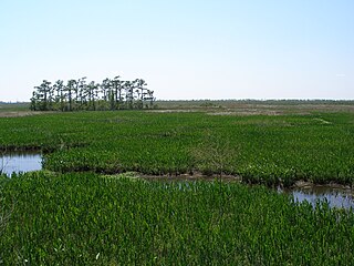
WJean Lafitte National Historical Park and Preserve protects the natural and cultural resources of Louisiana's Mississippi River Delta region. It is named after French pirate Jean Lafitte and consists of six separate sites and a park headquarters.
 W
WThe Louisiana Purchase Historic State Park commemorates the initial point from which the lands acquired through the Louisiana Purchase (1803) were subsequently surveyed. The protected area encompasses 37.5 acres (15.2 ha) of forested wetlands, a landform which is regionally in decline due to agricultural development practices that include draining such areas. In the center of the park is a 6-foot (1.8 m) marker erected in 1926 on the survey point by the L'Anguille Chapter of the Daughters of the American Revolution. The site was listed on the National Register of Historic Places (1972) and designated as a National Historic Landmark (1993).
 W
WThe Battle of Negro Fort was a brief and destructive siege of a fortification filled with fugitive slaves, free blacks, and Choctaw by the United States and their Creek allies. On Prospect Bluff, overlooking the Apalachicola River, a settlement and fortification that Andrew Jackson and other white Americans labeled Negro Fort existed for a brief period. It was built by the British in 1814, during the War of 1812, in a remote part of what was at the time Spanish Florida. It is part of the Prospect Bluff Historic Sites, in the Apalachicola National Forest, Franklin County, Florida. The term "Negro Fort" was coined by the Americans only after the British Army had departed Florida in the aftermath of the Treaty of Ghent in 1815; its later residents were primarily blacks, either being free Negroes or fugitive slaves, residing together with some Choctaws. There were a significant number of fugitive slaves already in the area before the fort was built, and beginning in 1804 there was for several years a trading post operating in the settlement. The blacks, having been slaves that worked on plantation, knew how to plant and care for crops, and also to care for domesticated animals, mostly cattle.
 W
WNorth Point State Battlefield is a publicly owned historic preserve in Dundalk, Baltimore County, Maryland, that commemorates a portion of the site where the Battle of North Point was fought during the War of 1812. On September 12, 1814, Brigadier General John Stricker commanded forces of the Maryland Militia from within the park's borders. Stricker's men fought the invading British forces from behind a fenceline along the monument's eastern edge.
 W
WPerry's Victory and International Peace Memorial commemorates the Battle of Lake Erie that took place near Ohio's South Bass Island, in which Commodore Oliver Hazard Perry led a fleet to victory in one of the most significant naval battles to occur in the War of 1812. Located on an isthmus on the island, the memorial also celebrates the lasting peace between Britain, Canada, and the United States that followed the war.
 W
WPigeon Roost State Historic Site is located between Scottsburg and Henryville, Indiana, near Underwood, Indiana. A one-lane road off U.S. Route 31 takes the visitor to the site of a village where Indians or Native Americans massacred 24 settlers shortly after the War of 1812 began.
 W
WPlattsburgh Bay, also known as Cumberland Bay, is an inlet on the western shore of Lake Champlain in Clinton County, New York. The bay is the location of the town and city of Plattsburgh, and was the site of the Battle of Plattsburgh, a naval and land engagement fought on September 11, 1814 late in the War of 1812. The bay and two land sites related to the battle were designated as a National Historic Landmark in 1960.
 W
WThe River Raisin National Battlefield Park was established as the 393rd unit of the United States National Park Service under Title VII of the Omnibus Public Land Management Act, which was signed into law on March 30, 2009. The park is located in the city of Monroe in Monroe County, Michigan. It was designated as a Michigan Historic Site on February 18, 1956 and was added to the National Register of Historic Places on December 10, 1982. The house at 1403 East Elm Avenue was added to the National Register listing in 2019. It officially began operation as a national park unit on October 22, 2010 and, of the four National Battlefield Parks in the country, it is the only one marking a site of the War of 1812.
 W
WSackets Harbor Battlefield State Historic Site is a historically important location in Jefferson County, New York, United States. The historic site is south of the Village of Sackets Harbor, bordering Lake Ontario in the Town of Hounsfield. Two battles were fought near this location during the War of 1812. Some 3,000 men worked at the shipyard building warships, and the village was fortified and garrisoned with thousands of troops.
 W
WThe Star-Spangled Banner National Historic Trail is a National Historic Trail that commemorates the Chesapeake Campaign of the War of 1812. The 290-mile (467 km) trail was named after "The Star-Spangled Banner," the national anthem of the United States. Consisting of water and overland routes, the trail extends from Tangier Island, Virginia, through southern Maryland, the District of Columbia, the Chesapeake Bay, and Baltimore, Maryland. The trail also contains sites on Maryland's Eastern shore.